Getting here
53.21616, -2.02504
Best for
4 activitiesDog walks
Free72%Dogs allowed with public access
Cycling
Varies65%Named cycling route nearby: Cheshire Cycleway
Hiking
Free65%Named hiking route nearby: Peak District Boundary Walk Stage 17
Heritage
Free55%Religious grounds — local heritage
Trails nearby
Within roughly 5 km🚶
Walking
30
9 named nearby · 21 public paths
Named routePublic access
🚴
Cycling
2
2 named nearby
Named route
🚵
Mountain biking
2
2 named nearby
Named route
Named routes and paths nearby
Manifold Trail · Walking0
Peak District Boundary Walk Stage 17 · Walking16.2 km
Gritstone Trail (River Dane - Rushton Spencer) · Walking0
Cheshire Cycleway · Cycling0
Banktop Road · public footpath
Banktop Road · public footpath
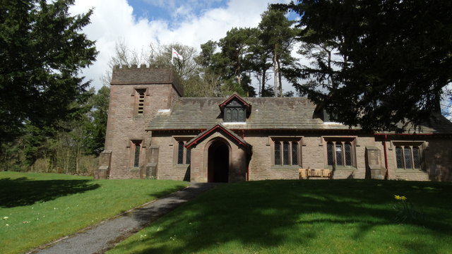
About this religious grounds
St Saviour's Church is a religious grounds.
Wildlife to spot
Photos
1 / 22
🌱 Visiting this spring
- 🐦Prime nesting season — listen for woodpecker drumming, warbler song and the first cuckoos from April
- 🦌Roe deer are active before the leaf canopy closes in — dawn and dusk are best
Facilities
🅿️
Parking
1 nearby · 188m
✓ Public accessFree entry🐶 Dogs
Good to know
- £Free to visit — no entry charge
- 🐕Dogs welcome
Weather for this location
Next 14 daysLoading local forecast…
Nearby places
Useful places within 5 km
💧Trentabank ReservoirReservoir3.3 km→✦Part of Goyt's Moss colliery, centered 220m south west of Derbyshire BridgeHistoric site4.2 km→✦Danebower Colliery ventilation chimneyHistoric site2.8 km→✦Danebower Colliery ventilation chimney, 750m north east of HoltHistoric site2.8 km→💧Trentabank ReservoirReservoir3.3 km→✦Round cairn 110m south west of Bartomley FarmHistoric site3.8 km→