Devil's Arrows and the Boroughbridge Heritage Trail: A Complete Guide
Three of Britain's tallest standing stones, a Roman town with mosaics still in the ground, three Neolithic henges, and a medieval battlefield — all within 10 miles of Boroughbridge. Here's everything worth knowing.

Devil's Arrows and the Boroughbridge Heritage Trail
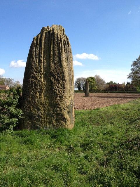
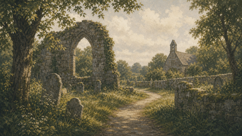
Most people drive past them on the B6265 without stopping. Three enormous standing stones — the tallest nearly seven metres — rising from flat agricultural land on the edge of a small Yorkshire market town. No visitor centre. No entry fee. No crowds. Just the stones.
Devil's Arrows at Boroughbridge is one of the most significant Bronze Age monuments in Britain, and one of the least visited. But the stones are only the beginning. Within ten miles there is a Roman town with mosaic floors still visible in the ground, three Neolithic triple henges that predate Stonehenge, a medieval battlefield, a moated manor house, and a country estate with some of the finest gardens in northern England. This guide covers all of it.
Devil's Arrows and Boroughbridge — mapped sites
8 areasStone alignment west of Boroughbridge known as the Devil's Arrows, including three standing stones and the setting for a fourth
Devil's Arrows
Devil's Arrows
Devil's Arrows
Aldborough Roman Site
Aldborough Roman town
Battle of Boroughbridge 1322
Studforth Hill
The Devil's Arrows
The Devil's Arrows are three standing stones arranged roughly north to south across the B6265 road through Boroughbridge — two in a field to the west, one to the east, separated by the modern road. They were probably four originally; the missing stone appears in early records and was reportedly broken up in the sixteenth century to build a bridge.
What remains is extraordinary. The tallest stone stands approximately 6.9 metres above ground — among the tallest standing stones in Britain. All three are made of millstone grit, a hard sandstone quarried from an outcrop near Knaresborough, roughly nine miles to the north-west. How they were moved and raised, with Bronze Age technology, across the Vale of York remains an open question.
The grooves at the top of each stone are worth looking at closely. Deep vertical channels run down the upper sections — not carved, but worn. This is natural weathering: rainwater tracking down the softer layers of the gritstone over three to four thousand years. The effect is almost architectural, as if the stones have been deliberately fluted. In early morning or evening light, when the shadows deepen in the grooves, the visual impact is considerable.
The name dates from at least the eighteenth century. Local folklore held that the devil hurled the stones from How Hill, aiming to destroy the nearby Roman town of Aldborough. He missed. The name stuck. An older name, recorded in medieval documents, is Arrows of the Devil — which suggests the legend is considerably older than the first written reference.
Dating and purpose remain debated. The most widely accepted estimate places their erection somewhere between 2000 and 1500 BC, in the early Bronze Age. Their alignment — broadly north to south, mirroring the orientation of the Thornborough Henges to the north-west — suggests a deliberate relationship with that larger complex. Whether they marked a processional route, a boundary, or something else entirely is unknown.
Visiting: The stones stand in open fields off the B6265, a few hundred metres south-west of Boroughbridge town centre. Free access at all times. The western pair are reached through a kissing gate off the road; the eastern stone is in a separate field. Park in Boroughbridge town centre (free car park on St James Square, YO51 9AR) and walk down.
On Glade: The three individual stones are recorded separately — stone one, stone two, stone three — alongside the scheduled monument boundary that covers the full site including the setting for the fourth, now-lost stone.
Aldborough Roman Town
One mile south-east of the Devil's Arrows, Aldborough Roman Town was the Roman settlement of Isurium Brigantum — the civitas capital of the Brigantes, the largest Iron Age tribe in Britain. Under Roman administration it became a prosperous market town with a forum, baths, and substantial stone buildings.
What survives is modest but remarkable. Two Roman mosaic floors remain in situ — visible beneath protective shelters in private gardens within the village, managed by English Heritage. The mosaics date from the second to fourth century AD and are among the best-preserved examples in northern England. There is a small on-site museum with finds from the excavations, including pottery, coins, and carved stonework.
The town walls — some of the best-preserved Roman defences in the north of England — are still visible in several sections, with stretches of the original Roman coursework surviving to near-full height in places. A circular walk around the village traces the wall line.
The Aldborough Cross stands in the village churchyard — a medieval cross on the site of the original Roman forum. Studforth Hill, an earthwork mound on the southern edge of the village, is thought to be a Norman motte associated with the later medieval settlement.
Visiting: The English Heritage site at Aldborough is open seasonally — check historicengland.org.uk for opening times. Entry charge applies for the museum and mosaics. The town walls and the exterior of the village are freely accessible year-round.
Getting there: Aldborough is a 20-minute walk from Boroughbridge along the River Ure, or a 5-minute drive. Postcode for the Roman site: YO51 9ER.
The Battle of Boroughbridge
In March 1322, the Battle of Boroughbridge took place at the crossing of the River Ure — a hundred metres from where you can stand today. Thomas, Earl of Lancaster, leading a baronial rebellion against Edward II, attempted to cross the bridge and ford with his forces. The royal army, under the Sheriff of Cumberland, held both crossings. Lancaster was captured, tried for treason at Pontefract Castle, and beheaded.
It was one of the decisive engagements of Edward II's troubled reign. The bridge itself has been rebuilt many times since, but the River Ure crossing and the flat ground of the battle site are unchanged. A short walk from the town centre takes you to the river, where an interpretation panel marks the site.
Thornborough Henges
Eight miles north-west of Boroughbridge, near the village of Thornborough, three Neolithic henges stand in a line across a ridge above the River Ure. Thornborough Henges — sometimes described as the Stonehenge of the North — are among the most significant prehistoric monuments in Britain, and among the least known.
Each henge is approximately 240 metres in diameter, with a double bank and ditch. They were built around 3000–2500 BC, predating Stonehenge's major phase by several centuries. Their alignment — south-east to north-west — mirrors the course of the Milky Way as it appeared in the Neolithic night sky, which has led to theories about astronomical significance.
The three henges are not all equally accessible. The northern henge and central henge are reachable via footpath from the village; the southern henge is more overgrown. All three are on private agricultural land with permissive access — and all three are ploughed arable fields, which means the banks and ditches are visible but the interior is farmland rather than preserved grassland.
The surrounding landscape contains significant additional archaeology. Earth circles, cursus monuments, and burial sites near Nosterfield extend the complex considerably. The whole area — sometimes called the Thornborough Ceremonial Complex — was one of the primary gathering places in Neolithic Britain.
Visiting: From the village of Thornborough, follow the public footpath east from the lane. An OS Explorer 299 is useful. Parking is limited to roadside in the village.
Nunwick Henge
Between Boroughbridge and Thornborough, and easily combined with either, the henge monument north of Nunwick is a scheduled Neolithic henge on private farmland near Skelton-on-Ure. Less visited than Thornborough, it sits in a quieter section of the River Ure valley. Access via public footpaths from Skelton-on-Ure village.
Newby Hall and Gardens
Three miles south-east of Boroughbridge, Newby Hall is a late seventeenth-century country house extended by Robert Adam in the 1760s. It is privately owned and open to visitors seasonally. The gardens are the main draw — 25 acres of formal and informal planting along the River Ure, with a double herbaceous border widely regarded as one of the best in England.
There is a children's miniature railway, adventure playground, and plant centre. For families combining a heritage day with something more active, Newby Hall works well as an afternoon stop after the morning's standing stones and Roman walls. Official site — check seasonal opening before visiting.
Markenfield Hall
Four miles west of Boroughbridge and two miles south of Ripon, Markenfield Hall is a fourteenth-century fortified manor house, moated, and one of the most complete examples of its type in England. The great hall, chapel, and tower survive largely intact — the kind of building that would be a major attraction in France and barely gets a road sign here.
It opens to visitors on limited days each year (typically May–June and occasional other dates). The scheduled monument designation covers the moat, buildings, and park pale. Worth planning around if the dates align.
Ripon
Five miles north-west of Boroughbridge, Ripon is the nearest city and worth a stop — particularly for Ripon Cathedral, which contains one of the oldest intact Saxon crypts in the world, dating from around 672 AD. The cathedral itself is free to enter. The city also has a Prison and Police Museum (in the original Victorian prison), the Workhouse Museum, and a market square with a 1,000-year-old tradition of the Hornblower setting the watch each evening at 9pm.
Practical Notes
Getting there: YO51 9LW for Boroughbridge town centre. The Devil's Arrows are a 10-minute walk from the free car park on St James Square. Aldborough is a mile south-east on foot or by road.
Parking: Free town centre parking in Boroughbridge. Aldborough has limited roadside parking in the village. Thornborough — roadside only in Thornborough village, which is very limited.
Combining sites: A logical full day: Devil's Arrows and Boroughbridge in the morning → Aldborough Roman Town → Newby Hall gardens in the afternoon. Thornborough Henges work better as a dedicated half-day from Boroughbridge or combined with a Ripon visit.
Dogs: Welcome at the Devil's Arrows, the Aldborough town walls exterior, and Thornborough footpath routes. Newby Hall has a dogs policy — check before visiting.
OS Map: Explorer 299 (Ripon & Boroughbridge) covers all the main sites in this guide.
Accessibility: The Devil's Arrows are reached via grass fields — uneven ground, no surfaced path. Aldborough village and the wall circuit are on tarmac roads. Newby Hall has accessible areas.
Boroughbridge and the Vale of York heritage corridor
18 places
Stone alignment west of Boroughbridge known as the Devil's Arrows, including three standing stones and the setting for a fourth
Devil's Arrows
Devil's Arrows
Devil's Arrows
Aldborough Roman Site
Aldborough Roman town
Aldborough Cross
Studforth Hill
Battle of Boroughbridge
Battle of Boroughbridge 1322
Thornborough Henges
Thornborough Henges
Thornborough Henges
Earth circles, cursus, pit alignments and burial sites near Nosterfield and Thornborough, including Centre Hill round barrow
Henge monument 300m north of Nunwick
Markenfield Hall
Newby Hall Grounds
Ripon Minster Close
Plan your visit with Glade
Glade has detailed pages for the historic sites, monuments, and green spaces in this area — wildlife records, trail data, facilities, and what's near each location.
Browse all sites near Boroughbridge →