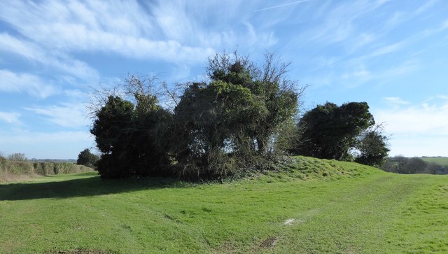
Norn`s Tump long barrow, 400m south-east of Hill Farm 0 ha
Plan your visit
🦅 Birds🦉 Wildlife✦ Heritage
Public access Free entry Dogs welcome 0 ha
Getting here
51.68419, -2.16151
Open directionsv ✦ Scheduled Ancient Monument — Nationally protected archaeological site on the National Heritage List for England (NHLE). Scheduled monuments represent the best surviving examples of England's irreplaceable archaeological heritage.
Archaeological site scheduled monument
Visiting this summer
Seasonal nature notes and what to look for now
▾ 🐦 67+ species recorded in this area — summer evenings are best for activity; watch for Woodpigeon and Blackbird ✦ Historic character is a year-round quality here — summer brings its own atmosphere to the setting 🐕 Dogs welcome — bring water in summer; the site has enough space to find shade on hot days 🌤️ Visiting this summer
🐦 67+ species recorded in this area — summer evenings are best for activity; watch for Woodpigeon and Blackbird ✦ Historic character is a year-round quality here — summer brings its own atmosphere to the setting 🐕 Dogs welcome — bring water in summer; the site has enough space to find shade on hot days £ Free to visit — no entry charge🐕 Dogs welcome🦅 Bird watching
Very strong match
Birds — Woodpigeon, Blackbird, Blue Tit +64 more · last seen 2026
Free
Mammals — Common Pipistrelle, Roe Deer, Rabbit +11 more · last seen 2024
Free
Historic site with public access
Free
🦋 Insect spotting
Strong match
Insects — Common Carder Bee, Bumblebee, Bombus lucorum +54 more · last seen 2025
Free
Dogs allowed with public access
Free
Named hiking route nearby: Macmillan Way; Named hiking route nearby: Macmillan Way
Free
Trails nearby Within roughly 5 km 4 signed routes nearby · 6 public paths nearby
Signed route nearby Public paths
Monarch's Way Walking route 990 km ▾
approximate route of Charles II's escape
Named route Ref MW Length 990 km Regional walking route
Show on map Macmillan Way Walking route 290 km ▾
Named route Ref MWA Length 290 km Listed length 461 Regional walking route
Show on map Wysis Way Walking route 88.5 km ▾
Long distance footpath forming a link between the Thames and the Wye
Named route Ref WYS Length 88.5 km Regional walking route
Show on map Thames & Severn Way Walking route 69.8 km ▾
Linking the Severn to the Thames following the route of the Stroudwater Navigation and Thames & Severn Canal as closely as possible using public rights of way. As the canals are restored, it will be updated to use the reinstated towpath wherever possible.
Named route Ref T&S W Length 69.8 km Point-to-point Regional walking route
Show on map 27 signed routes nearby
Signed route nearby
Mercian Way Cycling route ▾
Named route Ref 45 National Cycle Network
Show on map National Byway Cycling route ▾
Named route Ref NB Regional cycle route
Show on map Fosse2 Cycling route ▾
Named route Ref 48 National Cycle Network
Show on map Cotswold Cycleway Cycling route ▾
Named route Ref CC Regional cycle route
Show on map Main Route Cycling route 1.6 km ▾
Named route Ref 45 Length 1.6 km National Cycle Network Traffic-free Surface unsealedfirm
Show on map Main Route Cycling route 145 m ▾
Named route Ref 45 Length 145 m National Cycle Network Traffic-free Surface asphalt
Show on map 2 public paths nearby
Public paths
No named routes yet. Public paths are shown on the map.
Photos Norn's Tump long barrow, near Avening
‹ ›
Weather for this location Next 14 days Nearby places Useful places within 5 km
All Historic
UK green spaces mapped from open public data — so anyone can find the woodland, trail, or nature reserve closest to them.
© 2026 Glade · Made with care for UK green spaces
Events & activities nearby Switch provider to compare local events, tours and bookable activities.
Bookable tours GetYourGuide Tripadvisor
Wildlife to spot
6,924 records · National Biodiversity Network
▾
Wildlife to spot 6,924 records · National Biodiversity Network 🐦 Birds 13 species
summer autumn
2026 ▾
Barn Owl · Kestrel · Goldfinch · Pied Wagtail · Grey Wagtail +8
Barn Owl Tyto alba2025 Kestrel Falco tinnunculus Goldfinch Carduelis carduelis2025 Pied Wagtail Motacilla alba yarrellii2025 Grey Wagtail Motacilla cinerea2025 Golden Plover Pluvialis apricaria2024 Tawny Owl Strix aluco2024 Great Tit Parus major2024 Blue Tit Cyanistes caeruleus2024 Wren Troglodytes troglodytes2024 Blackbird Turdus merula2024 Starling Sturnus vulgaris2024 Swallow Hirundo rustica2024 🐸 Amphibians 2 species
winter spring
2026 ▾
Great Crested Newt · Common Toad
Great Crested Newt Triturus cristatus Common Toad Bufo bufo2025 Black-tailed Skimmer · Common Blue Damselfly · Common Darter · Ruddy Darter · Southern Hawker +5
Black-tailed Skimmer Orthetrum cancellatum Common Blue Damselfly Enallagma cyathigerum2024 Common Darter Sympetrum striolatum2024 Ruddy Darter Sympetrum sanguineum2024 Southern Hawker Aeshna cyanea Volucella pellucens Volucella pellucens Goat's-beard · Enchanter's-nightshade · Hedgerow Crane's-bill · Wild Strawberry · Cat's-ear +148
Goat's-beard Tragopogon pratensis Enchanter's-nightshade Circaea lutetiana Hedgerow Crane's-bill Geranium pyrenaicum Wild Strawberry Fragaria vesca Cat's-ear Hypochaeris radicata Common Mouse-ear Cerastium fontanum Broad-leaved Willowherb Species observations from the last 10 years via NBN Atlas
Helophilus pendulus Helophilus pendulus
Helophilus pendulus Helophilus pendulus
Dotted Bee-fly Bombylius discolor
Dotted Bee-fly Bombylius discolor
Oedemera femoralis Oedemera femoralis
Oedemera femoralis Oedemera femoralis
Emperor Dragonfly Anax imperator2024
Emperor Dragonfly Anax imperator2024 Epilobium montanum
Epilobium montanum
Common Bird's-foot-trefoil Lotus corniculatus
Common Bird's-foot-trefoil Lotus corniculatus
Male-fern Dryopteris filix-mas
Male-fern Dryopteris filix-mas
Dogwood Cornus sanguinea
Dogwood Cornus sanguinea
Shepherd's-purse Capsella bursa-pastoris
Shepherd's-purse Capsella bursa-pastoris
Annual Meadow-grass Poa annua
Annual Meadow-grass Poa annua
Polygonum aviculare Polygonum aviculare
Polygonum aviculare Polygonum aviculare
Field Penny-cress Thlaspi arvense
Field Penny-cress Thlaspi arvense
Sanicle Sanicula europaea
Sanicle Sanicula europaea
Parsley-piert Aphanes arvensis
Parsley-piert Aphanes arvensis
Dewberry Rubus caesius
Dewberry Rubus caesius
Timothy Phleum pratense
Timothy Phleum pratense
Marsh Thistle Cirsium palustre
Marsh Thistle Cirsium palustre
Bladder Campion Silene vulgaris
Bladder Campion Silene vulgaris
Thorn-apple Datura stramonium
Thorn-apple Datura stramonium
Upright Hedge-parsley Torilis japonica
Upright Hedge-parsley Torilis japonica
Rough Hawkbit Leontodon hispidus
Rough Hawkbit Leontodon hispidus
Common Spotted-orchid Dactylorhiza fuchsii
Common Spotted-orchid Dactylorhiza fuchsii
Welsh Poppy Papaver cambricum
Welsh Poppy Papaver cambricum
Hairy St John's-wort Hypericum hirsutum
Hairy St John's-wort Hypericum hirsutum
Red Campion Silene dioica
Red Campion Silene dioica
Phleum pratense Phleum pratense
Phleum pratense Phleum pratense
Spindle Euonymus europaeus
Spindle Euonymus europaeus
Early Dog-violet Viola reichenbachiana
Early Dog-violet Viola reichenbachiana
Small Scabious Scabiosa columbaria
Small Scabious Scabiosa columbaria
Welted Thistle Carduus crispus
Welted Thistle Carduus crispus
Montbretia Crocosmia aurea x pottsii = C. x crocosmiiflora
Montbretia Crocosmia aurea x pottsii = C. x crocosmiiflora
Musk-mallow Malva moschata
Musk-mallow Malva moschata
Bluebell Hyacinthoides non-scripta
Bluebell Hyacinthoides non-scripta
White Campion Silene latifolia
White Campion Silene latifolia
Druce's Crane's-bill Geranium endressii x versicolor = G. x oxonianum
Druce's Crane's-bill Geranium endressii x versicolor = G. x oxonianum
Wall Barley Hordeum murinum
Wall Barley Hordeum murinum
Sainfoin Onobrychis viciifolia
Sainfoin Onobrychis viciifolia
Guelder-rose Viburnum opulus
Guelder-rose Viburnum opulus
Autumn Hawkbit Scorzoneroides autumnalis
Autumn Hawkbit Scorzoneroides autumnalis
Wood Millet Milium effusum
Wood Millet Milium effusum
Wood-sedge Carex sylvatica
Wood-sedge Carex sylvatica
Canadian Fleabane Erigeron canadensis
Canadian Fleabane Erigeron canadensis
Barren Brome Anisantha sterilis
Barren Brome Anisantha sterilis
Silverweed Potentilla anserina
Silverweed Potentilla anserina
Yarrow Achillea millefolium
Yarrow Achillea millefolium
Sycamore Acer pseudoplatanus
Sycamore Acer pseudoplatanus
Yorkshire-fog Holcus lanatus
Yorkshire-fog Holcus lanatus
Oxeye Daisy Leucanthemum vulgare
Oxeye Daisy Leucanthemum vulgare
Common Nettle Urtica dioica
Common Nettle Urtica dioica
Common Vetch Vicia sativa
Common Vetch Vicia sativa
Wood Avens Geum urbanum
Wood Avens Geum urbanum
Pineappleweed Matricaria discoidea
Pineappleweed Matricaria discoidea
Wall Speedwell Veronica arvensis
Wall Speedwell Veronica arvensis
Common Rock-rose Helianthemum nummularium
Common Rock-rose Helianthemum nummularium
Rosa canina Rosa canina
Rosa canina Rosa canina
Cock's-foot Dactylis glomerata
Cock's-foot Dactylis glomerata
Elder Sambucus nigra
Elder Sambucus nigra
Upright Brome Bromopsis erecta
Upright Brome Bromopsis erecta
Field Madder Sherardia arvensis
Field Madder Sherardia arvensis
Kidney Vetch Anthyllis vulneraria
Kidney Vetch Anthyllis vulneraria
Creeping Cinquefoil Potentilla reptans
Creeping Cinquefoil Potentilla reptans
Field-rose Rosa arvensis
Field-rose Rosa arvensis
Black Medick Medicago lupulina
Black Medick Medicago lupulina
Wild Carrot Daucus carota
Wild Carrot Daucus carota
Tall Fescue Schedonorus arundinaceus
Tall Fescue Schedonorus arundinaceus
Great Willowherb Epilobium hirsutum
Great Willowherb Epilobium hirsutum
Blackthorn Prunus spinosa
Blackthorn Prunus spinosa
Festuca rubra Festuca rubra
Festuca rubra Festuca rubra
Woodruff Galium odoratum
Woodruff Galium odoratum
Pyramidal Orchid Anacamptis pyramidalis
Pyramidal Orchid Anacamptis pyramidalis
Dove's-foot Crane's-bill Geranium molle
Dove's-foot Crane's-bill Geranium molle
Meadow Buttercup Ranunculus acris
Meadow Buttercup Ranunculus acris
Field Scabious Knautia arvensis
Field Scabious Knautia arvensis
Wayfaring-tree Viburnum lantana
Wayfaring-tree Viburnum lantana
Walnut Juglans regia
Walnut Juglans regia
Lilac Syringa vulgaris
Lilac Syringa vulgaris
Beech Fagus sylvatica
Beech Fagus sylvatica
Hart's-Tongue Asplenium scolopendrium
Hart's-Tongue Asplenium scolopendrium
Meadow Vetchling Lathyrus pratensis
Meadow Vetchling Lathyrus pratensis
Bittersweet Solanum dulcamara
Bittersweet Solanum dulcamara
Hedge Mustard Sisymbrium officinale
Hedge Mustard Sisymbrium officinale
English Elm Ulmus procera
English Elm Ulmus procera
Hoary Ragwort Jacobaea erucifolia
Hoary Ragwort Jacobaea erucifolia
Field Bindweed Convolvulus arvensis
Field Bindweed Convolvulus arvensis
Floating Sweet-grass Glyceria fluitans
Floating Sweet-grass Glyceria fluitans
Field Forget-me-not Myosotis arvensis
Field Forget-me-not Myosotis arvensis
Common Spike-rush Eleocharis palustris
Common Spike-rush Eleocharis palustris
Greater Plantain Plantago major
Greater Plantain Plantago major
Rough Meadow-grass Poa trivialis
Rough Meadow-grass Poa trivialis
Wild Teasel Dipsacus fullonum
Wild Teasel Dipsacus fullonum
Lesser Trefoil Trifolium dubium
Lesser Trefoil Trifolium dubium
Wild Cherry Prunus avium
Wild Cherry Prunus avium
Common Field-speedwell Veronica persica
Common Field-speedwell Veronica persica
Hawthorn Crataegus monogyna
Hawthorn Crataegus monogyna
Brooklime Veronica beccabunga
Brooklime Veronica beccabunga
Wild Privet Ligustrum vulgare
Wild Privet Ligustrum vulgare
Ploughman's-spikenard Inula conyzae
Ploughman's-spikenard Inula conyzae
Aspen Populus tremula
Aspen Populus tremula
Common Chickweed Stellaria media
Common Chickweed Stellaria media
Crested Dog's-tail Cynosurus cristatus
Crested Dog's-tail Cynosurus cristatus
Groundsel Senecio vulgaris
Groundsel Senecio vulgaris
Selfheal Prunella vulgaris
Selfheal Prunella vulgaris
Perennial Rye-grass Lolium perenne
Perennial Rye-grass Lolium perenne
Glaucous Sedge Carex flacca
Glaucous Sedge Carex flacca
Norway Maple Acer platanoides
Norway Maple Acer platanoides
Cleavers Galium aparine
Cleavers Galium aparine
Hazel Corylus avellana
Hazel Corylus avellana
Red Dead-nettle Lamium purpureum
Red Dead-nettle Lamium purpureum
Smooth Hawk's-beard Crepis capillaris
Smooth Hawk's-beard Crepis capillaris
Hedge Woundwort Stachys sylvatica
Hedge Woundwort Stachys sylvatica
Dandelion Taraxacum
Dandelion Taraxacum
Lords-and-Ladies Arum maculatum
Lords-and-Ladies Arum maculatum
Meadow Crane's-bill Geranium pratense
Meadow Crane's-bill Geranium pratense
Ground-ivy Glechoma hederacea
Ground-ivy Glechoma hederacea
False Oat-grass Arrhenatherum elatius
False Oat-grass Arrhenatherum elatius
Hogweed Heracleum sphondylium
Hogweed Heracleum sphondylium
Daisy Bellis perennis
Daisy Bellis perennis
Holly Ilex aquifolium
Holly Ilex aquifolium
Salad Burnet Poterium sanguisorba
Salad Burnet Poterium sanguisorba
Nipplewort Lapsana communis
Nipplewort Lapsana communis
Black Bryony Tamus communis
Black Bryony Tamus communis
Swine-cress Lepidium coronopus
Swine-cress Lepidium coronopus
Field Pansy Viola arvensis
Field Pansy Viola arvensis
Creeping Buttercup Ranunculus repens
Creeping Buttercup Ranunculus repens
Watercress Nasturtium officinale
Watercress Nasturtium officinale
White Clover Trifolium repens
White Clover Trifolium repens
Ash Fraxinus excelsior
Ash Fraxinus excelsior
False-brome Brachypodium sylvaticum
False-brome Brachypodium sylvaticum
Black-grass Alopecurus myosuroides
Black-grass Alopecurus myosuroides
Greater Knapweed Centaurea scabiosa
Greater Knapweed Centaurea scabiosa
Germander Speedwell Veronica chamaedrys
Germander Speedwell Veronica chamaedrys
Common Ragwort Jacobaea vulgaris
Common Ragwort Jacobaea vulgaris
Cow Parsley Anthriscus sylvestris
Cow Parsley Anthriscus sylvestris
Cherry Laurel Prunus laurocerasus
Cherry Laurel Prunus laurocerasus
Traveller's-joy Clematis vitalba
Traveller's-joy Clematis vitalba
Prickly Sow-thistle Sonchus asper
Prickly Sow-thistle Sonchus asper
Clustered Dock Rumex conglomeratus
Clustered Dock Rumex conglomeratus
Water Mint Mentha aquatica
Water Mint Mentha aquatica
Broad-leaved Dock Rumex obtusifolius
Broad-leaved Dock Rumex obtusifolius
Garlic Mustard Alliaria petiolata
Garlic Mustard Alliaria petiolata
Curled Dock Rumex crispus
Curled Dock Rumex crispus
Hairy Tare Ervilia hirsuta
Hairy Tare Ervilia hirsuta
Ranunculus subg. Batrachium Ranunculus subg. Batrachium
Ranunculus subg. Batrachium Ranunculus subg. Batrachium
Herb-Robert Geranium robertianum
Herb-Robert Geranium robertianum
Cut-leaved Crane's-bill Geranium dissectum
Cut-leaved Crane's-bill Geranium dissectum
Creeping Thistle Cirsium arvense
Creeping Thistle Cirsium arvense
Black-bindweed Fallopia convolvulus
Black-bindweed Fallopia convolvulus
Field Maple Acer campestre
Field Maple Acer campestre
Wild-oat Avena fatua
Wild-oat Avena fatua
Hedera helix Hedera helix
Hedera helix Hedera helix
White Dead-nettle Lamium album
White Dead-nettle Lamium album