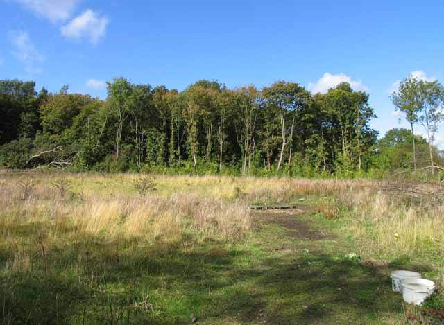
King Lud's Intrenchments and adjacent barrow
4 ha
Plan your visit
🦅Birds🌳Ancient🦉Wildlife
Free entryDogs welcome4 ha
Getting here
52.84232, -0.71709
Open directionsv
Visiting this summer
Seasonal nature notes and what to look for now
- 🐦45+ species recorded in this area — summer evenings are best for activity; watch for Yellowhammer and Chaffinch
- 💜Bluebell walks is at its best in summer here
- 🐕Dogs welcome — bring water in summer; the site has enough space to find shade on hot days
🌤️ Visiting this summer
- 🐦45+ species recorded in this area — summer evenings are best for activity; watch for Yellowhammer and Chaffinch
- 💜Bluebell walks is at its best in summer here
- 🐕Dogs welcome — bring water in summer; the site has enough space to find shade on hot days
Best for
9 activities🦅Bird watching
Very strong match
Birds — Yellowhammer, Chaffinch, Blackbird +42 more · last seen 2025; Deciduous woodland — woodpeckers, warblers and woodland birds
🌳Ancient woodland
Strong match
Ancient woodland — continuous woodland since before 1600
Birds — Yellowhammer, Chaffinch, Blackbird +42 more · last seen 2025; Deciduous woodland priority habitat
🦋Insect spotting
Strong match
Chalk and limestone grassland — chalkhill blue, adonis blue and rare moths; Insects — Peacock, Common Carpet, Brimstone +314 more · last seen 2025
🍂Seasonal nature
Strong match
Plants — Hairy St John's-wort, Viper's-bugloss, Field Maple +179 more · last seen 2025; Ancient woodland — bluebells, fungi and autumn colour
💜Bluebell walks
Strong match
Ancient woodland — native bluebell habitat
Trails nearby
Within roughly 5 km3 signed routes nearby
Signed route nearby
Viking Way (Barnetby to Whitwell)Walking route▾
Named routeRegional walking route
Mowbray WayWalking route14 km▾
Named routeLength 14 kmLocal walking route
Jubilee Way (Leicestershire)Walking route▾
Named routeRegional walking route
8 signed routes nearby
Signed route nearby
National Byway (Lincolnshire)Cycling route▾
The National Byway in Lincolnshire
Named routeRef NBRegional cycle route
Lincolnshire Cycle TrailCycling route▾
Named routeLocal cycle route
Route 64Cycling route▾
Named routeRef 64National Cycle Network
Alternative RouteCycling route2.6 km▾
Named routeRef 64Length 2.6 kmNational Cycle NetworkOn-roadSurface asphalt
Alternative RouteCycling route1.1 km▾
Named routeRef 64Length 1.1 kmNational Cycle NetworkOn-roadSurface asphalt
Alternative RouteCycling route21 m▾
Named routeRef 64Length 21 mNational Cycle NetworkOn-roadSurface asphalt
1 public path nearby
Public paths
The Driftbridleway · 381 m▾
Public pathbridlewayLength 381 mSurface dirtPath type: track
Photos
16 photos from nearby open sources
Good to know
- £Free to visit — no entry charge
- 🐕Dogs welcome
Weather for this location
Next 14 daysNearby places
Useful places within 5 km
Wildlife to spot
2,953 records from NBN Atlas
Wildlife to spot
2,953 records · NBN Atlas🐦Birds45 species
winterspring
2025Yellowhammer · Chaffinch · Blackbird · Woodpigeon · Skylark
+40 more speciesHide species list
All 45 birds recorded nearby (NBN Atlas)
- YellowhammerEmberiza citrinella
- ChaffinchFringilla coelebs
- BlackbirdTurdus merula
- WoodpigeonColumba palumbus
- SkylarkAlauda arvensis
- RookCorvus frugilegus
- RobinErithacus rubecula
- GoldfinchCarduelis carduelis
- WheatearOenanthe oenanthe2023
- JackdawColoeus monedula
- StarlingSturnus vulgaris
- LinnetLinaria cannabina
- Carrion CrowCorvus corone
- FieldfareTurdus pilaris
- ChiffchaffPhylloscopus collybita
- Common GullLarus canus2023
- Song ThrushTurdus philomelos
- WhitethroatCurruca communis
- Long-tailed TitAegithalos caudatus
- WrenTroglodytes troglodytes
- Blue TitCyanistes caeruleus
- DunnockPrunella modularis
- Red-legged PartridgeAlectoris rufa
- Mistle ThrushTurdus viscivorus
- Great TitParus major
- RedwingTurdus iliacus
- BlackcapSylvia atricapilla2022
- Collared DoveStreptopelia decaocto
- Garden WarblerSylvia borin
- Tawny OwlStrix aluco
- Grey PartridgePerdix perdix
- Meadow PipitAnthus pratensis
- Reed BuntingEmberiza schoeniclus
- MagpiePica pica
- TreecreeperCerthia familiaris
- PheasantPhasianus colchicus
- BramblingFringilla montifringilla2023
- RavenCorvus corax2023
- Yellow WagtailMotacilla flava2023
- Pied WagtailMotacilla alba2023
- StonechatSaxicola rubicola2023
- BullfinchPyrrhula pyrrhula2022
- Lesser WhitethroatCurruca curruca2022
- Willow WarblerPhylloscopus trochilus2022
- SwallowHirundo rustica2022
🦌Mammals5 species
winterspring
2025Brown Hare · Grey Squirrel · Roe Deer · Rabbit · Weasel
Peacock · Common Carpet · Brimstone · Setaceous Hebrew Character · Gatekeeper
+312 more speciesHide species list
All 317 insects recorded nearby (NBN Atlas)
- PeacockAglais io
- Common CarpetEpirrhoe alternata
- BrimstoneGonepteryx rhamni
- Setaceous Hebrew CharacterXestia c-nigrum2022
- GatekeeperPyronia tithonus
- Red AdmiralVanessa atalanta
Hairy St John's-wort · Viper's-bugloss · Field Maple · Red Campion · Sharp-leaved Fluellen
+177 more speciesHide species list
All 182 plants recorded nearby (NBN Atlas)
- Hairy St John's-wortHypericum hirsutum
- Viper's-buglossEchium vulgare
- Field MapleAcer campestre
- Red CampionSilene dioica2022
- Sharp-leaved FluellenKickxia elatine2022
- Ground-ivyGlechoma hederacea
Species observations from the last 10 years via NBN Atlas
Meadow Brown
Meadow Brown
Maniola jurtina2024
Maniola jurtina2024
Mother of PearlPatania ruralis2022Mother of PearlPatania ruralis2022Large Yellow UnderwingNoctua pronuba2021Large Yellow UnderwingNoctua pronuba2021Small WhitePieris rapaeSmall WhitePieris rapaeSpeckled WoodPararge aegeriaSpeckled WoodPararge aegeriaMagpie MothAbraxas grossulariata2022Magpie MothAbraxas grossulariata2022Common WainscotMythimna pallens2022Common WainscotMythimna pallens2022Lime-speck PugEupithecia centaureata2022Lime-speck PugEupithecia centaureata2022Common MarbleCelypha lacunana2022Common MarbleCelypha lacunana2022Common BluePolyommatus icarusCommon BluePolyommatus icarusBrimstone MothOpisthograptis luteolata2022Brimstone MothOpisthograptis luteolata2022Common Grass-veneerAgriphila tristella2022Common Grass-veneerAgriphila tristella2022Straw Grass-veneerAgriphila straminella2022Straw Grass-veneerAgriphila straminella2022Scalloped OakCrocallis elinguaria2022Scalloped OakCrocallis elinguaria2022Small GreyEudonia mercurella2022Small GreyEudonia mercurella2022Lesser Yellow UnderwingNoctua comes2022Lesser Yellow UnderwingNoctua comes2022SnoutHypena proboscidalis2022SnoutHypena proboscidalis2022Buff FootmanEilema depressa2022Buff FootmanEilema depressa2022Lesser Broad-bordered Yellow UnderwingNoctua janthe2022Lesser Broad-bordered Yellow UnderwingNoctua janthe2022Rosy TabbyEndotricha flammealis2022Rosy TabbyEndotricha flammealis2022Dingy FootmanEilema griseola2022Dingy FootmanEilema griseola2022Pale Straw PearlUdea lutealis2022Pale Straw PearlUdea lutealis2022Yellow-tailEuproctis similis2022Yellow-tailEuproctis similis2022Ash-bark Knot-hornEuzophera pinguis2022Ash-bark Knot-hornEuzophera pinguis2022Riband WaveIdaea aversata2022Riband WaveIdaea aversata2022Scarce FootmanEilema complana2022Scarce FootmanEilema complana2022Grey Knot-hornAcrobasis advenella2022Grey Knot-hornAcrobasis advenella2022Dusky SallowEremobia ochroleuca2022Dusky SallowEremobia ochroleuca2022Flame ShoulderOchropleura plecta2022Flame ShoulderOchropleura plecta2022Shuttle-shaped DartAgrotis puta2022Shuttle-shaped DartAgrotis puta2022Chinese CharacterCilix glaucata2022Chinese CharacterCilix glaucata2022Red Twin-spot CarpetXanthorhoe spadicearia2022Red Twin-spot CarpetXanthorhoe spadicearia2022Dun-barCosmia trapezina2022Dun-barCosmia trapezina2022Ruby TigerPhragmatobia fuliginosa2022Ruby TigerPhragmatobia fuliginosa2022Dusky ThornEnnomos fuscantaria2022Dusky ThornEnnomos fuscantaria2022Garden StrawAgapeta hamana2022Garden StrawAgapeta hamana2022Cloaked MinorMesoligia furuncula2022Cloaked MinorMesoligia furuncula2022Tufted ScallopYpsolopha scabrella2022Tufted ScallopYpsolopha scabrella2022Green CarpetColostygia pectinataria2022Green CarpetColostygia pectinataria2022Knot GrassAcronicta rumicis2022Knot GrassAcronicta rumicis2022Garden Grass-veneerChrysoteuchia culmella2022Garden Grass-veneerChrysoteuchia culmella2022Netted TortrixAcleris forsskaleana2022Netted TortrixAcleris forsskaleana2022Little GreyEudonia lacustrata2022Little GreyEudonia lacustrata2022Dark Fruit-tree TortrixPandemis heparana2022Dark Fruit-tree TortrixPandemis heparana2022Ringed China-markParapoynx stratiotata2022Ringed China-markParapoynx stratiotata2022Straw DotRivula sericealis2021Straw DotRivula sericealis2021Furness DowdBlastobasis adustella2021Furness DowdBlastobasis adustella2021Marbled WhiteMelanargia galatheaMarbled WhiteMelanargia galatheaRingletAphantopus hyperantusRingletAphantopus hyperantusLarge SkipperOchlodes sylvanusLarge SkipperOchlodes sylvanusSmall TortoiseshellAglais urticae2024Small TortoiseshellAglais urticae2024White Plume MothPterophorus pentadactyla2022White Plume MothPterophorus pentadactyla2022Silver YAutographa gamma2022Silver YAutographa gamma2022Bird-cherry ErmineYponomeuta evonymella2022Bird-cherry ErmineYponomeuta evonymella2022UncertainHoplodrina octogenaria2022UncertainHoplodrina octogenaria2022Broad-bordered Yellow UnderwingNoctua fimbriata2022Broad-bordered Yellow UnderwingNoctua fimbriata2022Single-dotted WaveIdaea dimidiata2022Single-dotted WaveIdaea dimidiata2022Large Twin-spot CarpetXanthorhoe quadrifasiata2022Large Twin-spot CarpetXanthorhoe quadrifasiata2022Purple BarCosmorhoe ocellata2022Purple BarCosmorhoe ocellata2022Chequered Grass-mothCatoptria falsella2022Chequered Grass-mothCatoptria falsella2022Purple ThornSelenia tetralunaria2022Purple ThornSelenia tetralunaria2022Yellow-spotted TortrixPseudargyrotoza conwagana2022Yellow-spotted TortrixPseudargyrotoza conwagana2022Black ArchesLymantria monacha2022Black ArchesLymantria monacha2022Marbled PiercerCydia splendana2022Marbled PiercerCydia splendana2022Cryptic Ash Bud MothPrays ruficeps2022Cryptic Ash Bud MothPrays ruficeps2022Black-fronted StrawCochylichroa atricapitana2022Black-fronted StrawCochylichroa atricapitana2022Mouse MothAmphipyra tragopoginis2022Mouse MothAmphipyra tragopoginis2022Pale Mottled WillowCaradrina clavipalpis2022Pale Mottled WillowCaradrina clavipalpis2022Meadow Hook-wingAncylis badiana2022Meadow Hook-wingAncylis badiana2022SprawlerAsteroscopus sphinx2021SprawlerAsteroscopus sphinx2021November Moth agg.Epirrita dilutata agg.2021November Moth agg.Epirrita dilutata agg.2021Mottled UmberErannis defoliaria2021Mottled UmberErannis defoliaria2021Red-green CarpetChloroclysta siterata2021Red-green CarpetChloroclysta siterata2021Feathered ThornColotois pennaria2021Feathered ThornColotois pennaria2021December MothPoecilocampa populi2021December MothPoecilocampa populi2021Black RusticAporophyla nigra2021Black RusticAporophyla nigra2021Garden Rose TortrixAcleris variegana2021Garden Rose TortrixAcleris variegana2021Lunar UnderwingAnchoscelis lunosa2021Lunar UnderwingAnchoscelis lunosa2021Common Marbled CarpetDysstroma truncata2021Common Marbled CarpetDysstroma truncata2021Copper UnderwingAmphipyra pyramidea2021Copper UnderwingAmphipyra pyramidea2021Brown-Spot PinionAnchoscelis litura2021Brown-Spot PinionAnchoscelis litura2021Frosted OrangeGortyna flavago2021Frosted OrangeGortyna flavago2021Square-spot RusticXestia xanthographa2021Square-spot RusticXestia xanthographa2021Beaded ChestnutAgrochola lychnidis2021Beaded ChestnutAgrochola lychnidis2021Green-brindled CrescentAllophyes oxyacanthae2021Green-brindled CrescentAllophyes oxyacanthae2021Holly TortrixRhopobota naevana2021Holly TortrixRhopobota naevana2021Orange SwiftTriodia sylvina2021Orange SwiftTriodia sylvina2021Common StrawCochylimorpha straminea2021Common StrawCochylimorpha straminea2021Six-striped RusticXestia sexstrigata2021Six-striped RusticXestia sexstrigata2021Chevron Grass-mothAgriphila geniculea2021Chevron Grass-mothAgriphila geniculea2021YponomeutaYponomeuta2021YponomeutaYponomeuta2021CnephasiaCnephasia2021CnephasiaCnephasia2021Small PhoenixEcliptopera silaceata2021Small PhoenixEcliptopera silaceata2021Square-spotted ClayXestia stigmatica2021Square-spotted ClayXestia stigmatica2021Flounced RusticLuperina testacea2021Flounced RusticLuperina testacea2021Painted LadyVanessa carduiPainted LadyVanessa carduiDark Green FritillarySpeyeria aglajaDark Green FritillarySpeyeria aglajaSmall SkipperThymelicus sylvestrisSmall SkipperThymelicus sylvestrisLarge WhitePieris brassicae2024Large WhitePieris brassicae2024Small HeathCoenonympha pamphilus2024Small HeathCoenonympha pamphilus2024Green-veined WhitePieris napi2023Green-veined WhitePieris napi2023Southern HawkerAeshna cyanea2022Southern HawkerAeshna cyanea2022Common Blue DamselflyEnallagma cyathigerum2022Common Blue DamselflyEnallagma cyathigerum2022Emperor DragonflyAnax imperator2022Emperor DragonflyAnax imperator2022Large GreyScoparia subfusca2022Large GreyScoparia subfusca2022Pearl Grass-mothCatoptria pinella2022Pearl Grass-mothCatoptria pinella2022Wakely's DowdBlastobasis lacticolella2022Wakely's DowdBlastobasis lacticolella2022Early ThornSelenia dentaria2022Early ThornSelenia dentaria2022Dark UmberPhilereme transversata britannica2022Dark UmberPhilereme transversata britannica2022Brown-line Bright-eyeMythimna conigera2022Brown-line Bright-eyeMythimna conigera2022Turnip MothAgrotis segetum2022Turnip MothAgrotis segetum2022Honeysuckle GreyAthrips mouffetella2022Honeysuckle GreyAthrips mouffetella2022Small China-markCataclysta lemnata2022Small China-markCataclysta lemnata2022Pallid GreyEudonia pallida2022Pallid GreyEudonia pallida2022Poplar Hawk-mothLaothoe populi2022Poplar Hawk-mothLaothoe populi2022Willow BeautyPeribatodes rhomboidaria2022Willow BeautyPeribatodes rhomboidaria2022Brown PlumeStenoptilia pterodactyla2022Brown PlumeStenoptilia pterodactyla2022Barred MarbleCelypha striana2022Barred MarbleCelypha striana2022CinnabarTyria jacobaeae2022CinnabarTyria jacobaeae2022Sycamore Leaf-minerPhyllonorycter geniculella2021Sycamore Leaf-minerPhyllonorycter geniculella2021Honeysuckle Leaf-minerPhyllonorycter emberizaepenella2021Honeysuckle Leaf-minerPhyllonorycter emberizaepenella2021Yellow-Line QuakerLeptologia macilenta2021Yellow-Line QuakerLeptologia macilenta2021Acleris laterana/comarianaAcleris laterana/comariana2021Acleris laterana/comarianaAcleris laterana/comariana2021Burnished BrassDiachrysia chrysitis2021Burnished BrassDiachrysia chrysitis2021Swallow ProminentPheosia tremula2021Swallow ProminentPheosia tremula2021Garden PebbleEvergestis forficalis2021Garden PebbleEvergestis forficalis2021Rosy RusticHydraecia micacea2021Rosy RusticHydraecia micacea2021Bulrush VeneerCalamotropha paludella2021Bulrush VeneerCalamotropha paludella2021Straw UnderwingThalpophila matura2021Straw UnderwingThalpophila matura2021Grass RivuletPerizoma albulataGrass RivuletPerizoma albulataCommaPolygonia c-albumCommaPolygonia c-albumDark-edged Bee-flyBombylius major2023Dark-edged Bee-flyBombylius major2023Roesel's Bush-cricketRoeseliana roeselii2022Roesel's Bush-cricketRoeseliana roeselii2022Barred StrawGandaritis pyraliata2022Barred StrawGandaritis pyraliata2022RivuletPerizoma affinitata2022RivuletPerizoma affinitata2022HeraldScoliopteryx libatrix2022HeraldScoliopteryx libatrix2022Red-barred TortrixDitula angustiorana2022Red-barred TortrixDitula angustiorana2022Shaded Broad-barScotopteryx chenopodiata2022Shaded Broad-barScotopteryx chenopodiata2022CampionSideridis rivularis2022CampionSideridis rivularis2022Copper-fringed DrabSwammerdamia pyrella2022Copper-fringed DrabSwammerdamia pyrella2022Buff ArchesHabrosyne pyritoides2022Buff ArchesHabrosyne pyritoides2022Small Blood-veinScopula imitaria2022Small Blood-veinScopula imitaria2022Golden-brown TubicCrassa unitella2022Golden-brown TubicCrassa unitella2022PhoenixEulithis prunata2022PhoenixEulithis prunata2022Chocolate-tipClostera curtula2022Chocolate-tipClostera curtula2022Bright BellEucosma hohenwartiana2022Bright BellEucosma hohenwartiana2022CoronetCraniophora ligustri2022CoronetCraniophora ligustri2022Yarrow PlumeGillmeria pallidactyla2022Yarrow PlumeGillmeria pallidactyla2022Yellow ShellCamptogramma bilineata2022Yellow ShellCamptogramma bilineata2022White Satin MothLeucoma salicis2022White Satin MothLeucoma salicis2022Hoary TortrixEucosma cana2022Hoary TortrixEucosma cana2022Common Zebra MothHelcystogramma rufescens2022Common Zebra MothHelcystogramma rufescens2022Light ArchesApamea lithoxylaea2022Light ArchesApamea lithoxylaea2022Twin-barred Knot-hornHomoeosoma sinuella2022Twin-barred Knot-hornHomoeosoma sinuella2022Dark ArchesApamea monoglypha2022Dark ArchesApamea monoglypha2022DrinkerEuthrix potatoria2022DrinkerEuthrix potatoria2022Ruddy CarpetCatarhoe rubidata2022Ruddy CarpetCatarhoe rubidata2022Large Fruit-tree TortrixArchips podana2022Large Fruit-tree TortrixArchips podana2022Oak Hook-tipWatsonalla binaria2022Oak Hook-tipWatsonalla binaria2022Bright StrawAgapeta zoegana2022Bright StrawAgapeta zoegana2022Timothy TortrixZelotherses paleana2022Timothy TortrixZelotherses paleana2022Bud MothSpilonota ocellana2022Bud MothSpilonota ocellana2022Ear MothAmphipoea oculea2022Ear MothAmphipoea oculea2022Lesser Tawny CrescentBatia lunaris2022Lesser Tawny CrescentBatia lunaris2022Tawny Sycamore PiercerPammene aurita2022Tawny Sycamore PiercerPammene aurita2022Common LutestringOchropacha duplaris2022Common LutestringOchropacha duplaris2022Dark Seedhead MothApodia bifractella2022Dark Seedhead MothApodia bifractella2022Thistle ErmineMyelois circumvoluta2022Thistle ErmineMyelois circumvoluta2022Common FootmanEilema lurideola2022Common FootmanEilema lurideola2022V-pugChloroclystis v-ata2022V-pugChloroclystis v-ata2022Dark Blackthorn Tip MothArgyresthia albistria2022Dark Blackthorn Tip MothArgyresthia albistria2022Common GreyScoparia ambigualis2022Common GreyScoparia ambigualis2022Ling PugEupithecia absinthiata2022Ling PugEupithecia absinthiata2022Pebble Hook-tipDrepana falcataria2022Pebble Hook-tipDrepana falcataria2022Small Dotted BuffPhotedes minima2022Small Dotted BuffPhotedes minima2022TissueTriphosa dubitata2022TissueTriphosa dubitata2022SpectacleAbrostola tripartita2022SpectacleAbrostola tripartita2022Plum TortrixHedya pruniana2022Plum TortrixHedya pruniana2022Peach BlossomThyatira batis2022Peach BlossomThyatira batis2022Water VeneerAcentria ephemerella2022Water VeneerAcentria ephemerella2022Purple-shaded BrownAgonopterix liturosa2022Purple-shaded BrownAgonopterix liturosa2022July HighflyerHydriomena furcata2022July HighflyerHydriomena furcata2022Roseate MarbleCelypha rosaceana2022Roseate MarbleCelypha rosaceana2022Barred YellowCidaria fulvata2022Barred YellowCidaria fulvata2022Cyclamen TortrixClepsis spectrana2022Cyclamen TortrixClepsis spectrana2022Hedge Hook-wingAncylis achatana2022Hedge Hook-wingAncylis achatana2022Latticed HeathChiasmia clathrata2022Latticed HeathChiasmia clathrata2022Fenland PearlAnania perlucidalis2022Fenland PearlAnania perlucidalis2022Marbled White SpotProtodeltote pygarga2022Marbled White SpotProtodeltote pygarga2022Short-cloaked MothNola cucullatella2022Short-cloaked MothNola cucullatella2022Hazel Bud MothParachronistis albiceps2022Hazel Bud MothParachronistis albiceps2022Fan-footHerminia tarsipennalis2022Fan-footHerminia tarsipennalis2022Slender Rufous TortrixLathronympha strigana2022Slender Rufous TortrixLathronympha strigana2022Acorn PiercerPammene fasciana2022Acorn PiercerPammene fasciana2022DelicateMythimna vitellina2022DelicateMythimna vitellina2022Least CarpetIdaea rusticata2022Least CarpetIdaea rusticata2022FlameAxylia putris2022FlameAxylia putris2022Barred Hook-tipWatsonalla cultraria2022Barred Hook-tipWatsonalla cultraria2022Least Yellow UnderwingNoctua interjecta caliginosa2022Least Yellow UnderwingNoctua interjecta caliginosa2022Coxcomb ProminentPtilodon capucina2022Coxcomb ProminentPtilodon capucina2022Beautiful Hook-tipLaspeyria flexula2022Beautiful Hook-tipLaspeyria flexula2022White-faced TortrixPandemis cinnamomeana2022White-faced TortrixPandemis cinnamomeana2022White-headed DrabParaswammerdamia albicapitella2022White-headed DrabParaswammerdamia albicapitella2022Peppered MothBiston betularia2022Peppered MothBiston betularia2022Variegated Golden TortrixArchips xylosteana2022Variegated Golden TortrixArchips xylosteana2022Double-striped TabbyHypsopygia glaucinalis2022Double-striped TabbyHypsopygia glaucinalis2022Iron ProminentNotodonta dromedarius2022Iron ProminentNotodonta dromedarius2022ClayMythimna ferrago2022ClayMythimna ferrago2022Campion GroundlingCaryocolum viscariella2022Campion GroundlingCaryocolum viscariella2022Light Brown Apple MothEpiphyas postvittana2022Light Brown Apple MothEpiphyas postvittana2022Small MagpieAnania hortulata2022Small MagpieAnania hortulata2022Satin BeautyDeileptenia ribeata2022Satin BeautyDeileptenia ribeata2022Apple Leaf MinerLyonetia clerkella2022Apple Leaf MinerLyonetia clerkella2022Dusky PearlUdea prunalis2022Dusky PearlUdea prunalis2022Double-striped PugGymnoscelis rufifasciata2022Double-striped PugGymnoscelis rufifasciata2022Hollyhock Seed MothPexicopia malvella2022Hollyhock Seed MothPexicopia malvella2022VapourerOrgyia antiqua2022VapourerOrgyia antiqua2022Clouded BorderLomaspilis marginata2022Clouded BorderLomaspilis marginata2022Smoky WainscotMythimna impura2022Smoky WainscotMythimna impura2022White-foot MothEpiblema foenella2022White-foot MothEpiblema foenella2022Dark-fringed Flat-bodyAgonopterix nervosa2022Dark-fringed Flat-bodyAgonopterix nervosa2022Birch MarbleApotomis betuletana2022Birch MarbleApotomis betuletana2022Small Angle ShadesEuplexia lucipara2022Small Angle ShadesEuplexia lucipara2022Common GroundlingTeleiodes vulgella2022Common GroundlingTeleiodes vulgella2022Hawthorn Tip MothArgyresthia bonnetella2022Hawthorn Tip MothArgyresthia bonnetella2022Scalloped Hook-tipFalcaria lacertinaria2022Scalloped Hook-tipFalcaria lacertinaria2022Dark Moss-mothBryotropha affinis2022Dark Moss-mothBryotropha affinis2022Common Cloaked TortrixGypsonoma dealbana2022Common Cloaked TortrixGypsonoma dealbana2022Blood-veinTimandra comae2022Blood-veinTimandra comae2022Burdock StrawAethes rubigana2022Burdock StrawAethes rubigana2022Hawthorn PiercerGrapholita janthinana2022Hawthorn PiercerGrapholita janthinana2022Fen WainscotArenostola phragmitidis2022Fen WainscotArenostola phragmitidis2022Golden-rod PugEupithecia virgaureata2022Golden-rod PugEupithecia virgaureata2022Rufous TortrixClepsis consimilana2022Rufous TortrixClepsis consimilana2022White-marked TortrixAcleris holmiana2022White-marked TortrixAcleris holmiana2022Light EmeraldCampaea margaritaria2022Light EmeraldCampaea margaritaria2022Amber MomphaMompha ochraceella2022Amber MomphaMompha ochraceella2022Satin Grass-mothCrambus perlella2022Satin Grass-mothCrambus perlella2022Hawthorn Berry MothBlastodacna hellerella2022Hawthorn Berry MothBlastodacna hellerella2022Hemlock MothAgonopterix alstromeriana2022Hemlock MothAgonopterix alstromeriana2022Tawny Speckled PugEupithecia icterata subsp. subfulvata2022Tawny Speckled PugEupithecia icterata subsp. subfulvata2022Large EmeraldGeometra papilionaria2022Large EmeraldGeometra papilionaria2022Oak NycteolineNycteola revayana2022Oak NycteolineNycteola revayana2022Marbled Orchard TortrixHedya nubiferana2022Marbled Orchard TortrixHedya nubiferana2022Oak Knot-hornPhycita roborella2022Oak Knot-hornPhycita roborella2022Willow ErmineYponomeuta rorrella2022Willow ErmineYponomeuta rorrella2022RusticHoplodrina blanda2022RusticHoplodrina blanda2022Long-horned Flat-bodyCarcina quercana2022Long-horned Flat-bodyCarcina quercana2022Gorse WandererBrachmia blandella2022Gorse WandererBrachmia blandella2022Round-winged MuslinThumatha senex2022Round-winged MuslinThumatha senex2022Ash SpinnerZelleria hepariella2022Ash SpinnerZelleria hepariella2022Nettle-TapAnthophila fabriciana2022Nettle-TapAnthophila fabriciana2022Gold TriangleHypsopygia costalis2022Gold TriangleHypsopygia costalis2022Bulrush CosmetLimnaecia phragmitella2022Bulrush CosmetLimnaecia phragmitella2022Codling MothCydia pomonella2022Codling MothCydia pomonella2022Diamond-back MothPlutella xylostella2022Diamond-back MothPlutella xylostella2022Clouded SilverLomographa temerata2022Clouded SilverLomographa temerata2022Beech Mast PiercerCydia fagiglandana2022Beech Mast PiercerCydia fagiglandana2022Shaded TortrixEucosma obumbratana2022Shaded TortrixEucosma obumbratana2022LychnisHadena bicruris2022LychnisHadena bicruris2022Heart & DartAgrotis exclamationis2022Heart & DartAgrotis exclamationis2022Hawthorn DrabParaswammerdamia nebulella2022Hawthorn DrabParaswammerdamia nebulella2022Spotted Knot-hornPhycitodes binaevella2022Spotted Knot-hornPhycitodes binaevella2022Lettuce TortrixEucosma conterminana2022Lettuce TortrixEucosma conterminana2022Knapweed Seedhead MothMetzneria metzneriella2022Knapweed Seedhead MothMetzneria metzneriella2022Diamond-back MarbleEudemis profundana2022Diamond-back MarbleEudemis profundana2022Bordered MarbleEndothenia marginana2022Bordered MarbleEndothenia marginana2022Double-square SpotXestia triangulum2022Double-square SpotXestia triangulum2022Spike-rush BorerMonochroa lucidella2022Spike-rush BorerMonochroa lucidella2022Mottled BeautyAlcis repandata2022Mottled BeautyAlcis repandata2022Leopard MothZeuzera pyrina2022Leopard MothZeuzera pyrina2022Privet Hawk-mothSphinx ligustri2022Privet Hawk-mothSphinx ligustri2022Garden CarpetXanthorhoe fluctuata2022Garden CarpetXanthorhoe fluctuata2022Barred Fruit-tree TortrixPandemis cerasana2022Barred Fruit-tree TortrixPandemis cerasana2022Rufous StiltCaloptilia rufipennella2022Rufous StiltCaloptilia rufipennella2022Small RivuletPerizoma alchemillata2022Small RivuletPerizoma alchemillata2022Ribwort StiltAspilapteryx tringipennella2022Ribwort StiltAspilapteryx tringipennella2022Elm GreyCarpatolechia fugitivella2022Elm GreyCarpatolechia fugitivella2022Bright-line Brown-eyeLacanobia oleracea2022Bright-line Brown-eyeLacanobia oleracea2022Teasel MarbleEndothenia gentianaeana2022Teasel MarbleEndothenia gentianaeana2022Rush VeneerNomophila noctuella2022Rush VeneerNomophila noctuella2022Buff ErmineSpilosoma lutea2022Buff ErmineSpilosoma lutea2022Thistle MarbleLobesia abscisana2022Thistle MarbleLobesia abscisana2022Willow StiltCaloptilia stigmatella2022Willow StiltCaloptilia stigmatella2022Hypericum NebOxypteryx atrella2022Hypericum NebOxypteryx atrella2022NutmegAnarta trifolii2022NutmegAnarta trifolii2022Tree-lichen BeautyCryphia algae2022Tree-lichen BeautyCryphia algae2022Bramble Shoot MothNotocelia uddmanniana2022Bramble Shoot MothNotocelia uddmanniana2022Orange-tipAnthocharis cardamines2022Orange-tipAnthocharis cardamines2022ChestnutConistra vaccinii2021ChestnutConistra vaccinii2021BrickSunira circellaris2021BrickSunira circellaris2021Lead-coloured TortrixAcleris sparsana2021Lead-coloured TortrixAcleris sparsana2021Dark ChestnutConistra ligula2021Dark ChestnutConistra ligula2021Spruce CarpetThera britannica2021Spruce CarpetThera britannica2021SatelliteEupsilia transversa2021SatelliteEupsilia transversa2021Rhomboid TortrixAcleris rhombana2021Rhomboid TortrixAcleris rhombana2021Deep-brown DartAporophyla lueneburgensis2021Deep-brown DartAporophyla lueneburgensis2021Horse-Chestnut Leaf-minerCameraria ohridella2021Horse-Chestnut Leaf-minerCameraria ohridella2021Yellow-barred BrindleAcasis viretata2021Yellow-barred BrindleAcasis viretata2021Blackthorn Tip MothArgyresthia spinosella2021Blackthorn Tip MothArgyresthia spinosella2021Carrion MothMonopis weaverella2021Carrion MothMonopis weaverella2021Pale-streaked Grass-mothAgriphila selasella2021Pale-streaked Grass-mothAgriphila selasella2021Common Rustic agg.Mesapamea secalis agg.2021Common Rustic agg.Mesapamea secalis agg.2021Rusty DotUdea ferrugalis2021Rusty DotUdea ferrugalis2021Honeysuckle MothYpsolopha dentella2021Honeysuckle MothYpsolopha dentella2021Small Rufous TortrixAcleris aspersana2021Small Rufous TortrixAcleris aspersana2021Currant PugEupithecia assimilata2021Currant PugEupithecia assimilata2021Slender BrindleApamea scolopacina2021Slender BrindleApamea scolopacina2021Dark-marked TortrixAcleris laterana2021Dark-marked TortrixAcleris laterana2021Common Daisy MothDichrorampha acuminatana2021Common Daisy MothDichrorampha acuminatana2021Buff Grey TortrixCnephasia longana2021Buff Grey TortrixCnephasia longana20212022
2022
Basil ThymeClinopodium acinos2022Basil ThymeClinopodium acinos2022Dwarf SpurgeEuphorbia exiguaDwarf SpurgeEuphorbia exiguaCornflowerCentaurea cyanusCornflowerCentaurea cyanusSmall ToadflaxChaenorhinum minusSmall ToadflaxChaenorhinum minusDotted LoosestrifeLysimachia punctataDotted LoosestrifeLysimachia punctataBetonyBetonica officinalis2024BetonyBetonica officinalis2024Meadow Crane's-billGeranium pratense2024Meadow Crane's-billGeranium pratense2024Creeping ButtercupRanunculus repens2022Creeping ButtercupRanunculus repens2022Goat WillowSalix caprea2022Goat WillowSalix caprea2022Crested Dog's-tailCynosurus cristatus2022Crested Dog's-tailCynosurus cristatus2022BulrushTypha latifolia2022BulrushTypha latifolia2022Petty SpurgeEuphorbia peplus2022Petty SpurgeEuphorbia peplus2022White CloverTrifolium repens2022White CloverTrifolium repens2022BrooklimeVeronica beccabunga2022BrooklimeVeronica beccabunga2022Scentless MayweedTripleurospermum inodorum2022Scentless MayweedTripleurospermum inodorum2022Remote SedgeCarex remota2022Remote SedgeCarex remota2022Greater PlantainPlantago major2022Greater PlantainPlantago major2022BlackthornPrunus spinosa2022BlackthornPrunus spinosa2022Ribwort PlantainPlantago lanceolata2022Ribwort PlantainPlantago lanceolata2022CleaversGalium aparine2022CleaversGalium aparine2022Great MulleinVerbascum thapsus2022Great MulleinVerbascum thapsus2022Wall SpeedwellVeronica arvensis2022Wall SpeedwellVeronica arvensis2022Creeping BentAgrostis stolonifera2022Creeping BentAgrostis stolonifera2022Amphibious BistortPersicaria amphibia2022Amphibious BistortPersicaria amphibia2022Wood AvensGeum urbanum2022Wood AvensGeum urbanum2022Broad-leaved DockRumex obtusifolius2022Broad-leaved DockRumex obtusifolius2022Lesser StitchwortStellaria graminea2022Lesser StitchwortStellaria graminea2022Annual Meadow-grassPoa annua2022Annual Meadow-grassPoa annua2022Wall CotoneasterCotoneaster horizontalis2022Wall CotoneasterCotoneaster horizontalis2022Common Spike-rushEleocharis palustris2022Common Spike-rushEleocharis palustris2022Guelder-roseViburnum opulus2022Guelder-roseViburnum opulus2022Field Forget-me-notMyosotis arvensis2022Field Forget-me-notMyosotis arvensis2022Common MallowMalva sylvestris2022Common MallowMalva sylvestris2022Oxeye DaisyLeucanthemum vulgare2022Oxeye DaisyLeucanthemum vulgare2022Bearded CouchElymus caninus2022Bearded CouchElymus caninus2022Broad-leaved PondweedPotamogeton natans2022Broad-leaved PondweedPotamogeton natans2022Upright Hedge BedstrawGalium album subsp. erectum2022Upright Hedge BedstrawGalium album subsp. erectum2022Creeping CinquefoilPotentilla reptans2022Creeping CinquefoilPotentilla reptans2022Great BindweedCalystegia sepium subsp. sepium2022Great BindweedCalystegia sepium subsp. sepium2022Wall-rueAsplenium ruta-muraria2022Wall-rueAsplenium ruta-muraria2022Common OracheAtriplex patula2022Common OracheAtriplex patula2022Lords-and-LadiesArum maculatum2022Lords-and-LadiesArum maculatum2022BrambleRubus fruticosus2022BrambleRubus fruticosus2022Annual PearlwortSagina apetala2022Annual PearlwortSagina apetala2022Soft-rushJuncus effusus2022Soft-rushJuncus effusus2022Great WillowherbEpilobium hirsutum2022Great WillowherbEpilobium hirsutum2022PineappleweedMatricaria discoidea2022PineappleweedMatricaria discoidea2022Cock's-footDactylis glomerata2022Cock's-footDactylis glomerata2022WalnutJuglans regia2022WalnutJuglans regia2022Tall FescueSchedonorus arundinaceus2022Tall FescueSchedonorus arundinaceus2022Red BartsiaOdontites vernus2022Red BartsiaOdontites vernus2022SnapdragonAntirrhinum majus2022SnapdragonAntirrhinum majus2022IvyHedera helix2022IvyHedera helix2022Wild PrivetLigustrum vulgare2022Wild PrivetLigustrum vulgare2022Common Mouse-earCerastium fontanum2022Common Mouse-earCerastium fontanum2022Horse-chestnutAesculus hippocastanum2022Horse-chestnutAesculus hippocastanum2022Hedge WoundwortStachys sylvatica2022Hedge WoundwortStachys sylvatica2022Lapsana communis subsp. communisLapsana communis subsp. communis2022Lapsana communis subsp. communisLapsana communis subsp. communis2022Tufted VetchVicia cracca2022Tufted VetchVicia cracca2022Silver BirchBetula pendula2022Silver BirchBetula pendula2022Black MedickMedicago lupulina2022Black MedickMedicago lupulina2022Field BindweedConvolvulus arvensis2022Field BindweedConvolvulus arvensis2022Rough Meadow-grassPoa trivialis2022Rough Meadow-grassPoa trivialis2022Chenopodium albumChenopodium album2022Chenopodium albumChenopodium album2022ElderSambucus nigra2022ElderSambucus nigra2022Reflexed Saltmarsh-GrassPuccinellia distans2022Reflexed Saltmarsh-GrassPuccinellia distans2022Jointed RushJuncus articulatus2022Jointed RushJuncus articulatus2022GroundselSenecio vulgaris2022GroundselSenecio vulgaris2022Ranunculus subg. BatrachiumRanunculus subg. Batrachium2022Ranunculus subg. BatrachiumRanunculus subg. Batrachium2022Tufted Hair-grassDeschampsia cespitosa2022Tufted Hair-grassDeschampsia cespitosa2022Meadow BarleyHordeum secalinum2022Meadow BarleyHordeum secalinum2022Plicate Sweet-grassGlyceria notata2022Plicate Sweet-grassGlyceria notata2022Water MintMentha aquatica2022Water MintMentha aquatica2022Japanese RoseRosa rugosa2022Japanese RoseRosa rugosa2022Red GoosefootOxybasis rubra2022Red GoosefootOxybasis rubra2022Hedgerow Crane's-billGeranium pyrenaicum2022Hedgerow Crane's-billGeranium pyrenaicum2022Great BurnetSanguisorba officinalis2022Great BurnetSanguisorba officinalis2022Grey PoplarPopulus alba x tremula = P. x canescens2022Grey PoplarPopulus alba x tremula = P. x canescens2022BullacePrunus domestica subsp. insititia2022BullacePrunus domestica subsp. insititia2022Polygonum avicularePolygonum aviculare2022Polygonum avicularePolygonum aviculare2022Garlic MustardAlliaria petiolata2022Garlic MustardAlliaria petiolata2022Traveller's-joyClematis vitalba2022Traveller's-joyClematis vitalba2022Water-StarwortCallitriche2022Water-StarwortCallitriche2022Square-stalked WillowherbEpilobium tetragonum2022Square-stalked WillowherbEpilobium tetragonum2022Rosa caninaRosa canina2022Rosa caninaRosa canina2022Hedge MustardSisymbrium officinale2022Hedge MustardSisymbrium officinale2022Sun SpurgeEuphorbia helioscopia2022Sun SpurgeEuphorbia helioscopia2022Common SorrelRumex acetosa2022Common SorrelRumex acetosa2022Glaucous SedgeCarex flacca2022Glaucous SedgeCarex flacca2022False Oat-grassArrhenatherum elatius2022False Oat-grassArrhenatherum elatius2022SycamoreAcer pseudoplatanus2022SycamoreAcer pseudoplatanus2022False-bromeBrachypodium sylvaticum2022False-bromeBrachypodium sylvaticum2022Shepherd's-purseCapsella bursa-pastoris2022Shepherd's-purseCapsella bursa-pastoris2022SilverweedPotentilla anserina2022SilverweedPotentilla anserina2022Welted ThistleCarduus crispus2022Welted ThistleCarduus crispus2022Celery-leaved ButtercupRanunculus sceleratus2022Celery-leaved ButtercupRanunculus sceleratus2022TimothyPhleum pratense2022TimothyPhleum pratense2022Common RagwortJacobaea vulgaris2022Common RagwortJacobaea vulgaris2022Yorkshire-fogHolcus lanatus2022Yorkshire-fogHolcus lanatus2022BuckthornRhamnus cathartica2022BuckthornRhamnus cathartica2022Curled DockRumex crispus2022Curled DockRumex crispus2022Hoary WillowherbEpilobium parviflorum2022Hoary WillowherbEpilobium parviflorum2022Reed Canary-grassPhalaris arundinacea2022Reed Canary-grassPhalaris arundinacea2022Clustered DockRumex conglomeratus2022Clustered DockRumex conglomeratus2022Spear ThistleCirsium vulgare2022Spear ThistleCirsium vulgare2022Hairy SedgeCarex hirta2022Hairy SedgeCarex hirta2022Meadow ButtercupRanunculus acris2022Meadow ButtercupRanunculus acris2022Ground-elderAegopodium podagraria2022Ground-elderAegopodium podagraria2022Black BryonyTamus communis2022Black BryonyTamus communis2022HawthornCrataegus monogyna2022HawthornCrataegus monogyna2022Red FescueFestuca rubra2022Red FescueFestuca rubra2022Wych ElmUlmus glabra2022Wych ElmUlmus glabra2022Wild AngelicaAngelica sylvestris2022Wild AngelicaAngelica sylvestris2022Rough ChervilChaerophyllum temulum2022Rough ChervilChaerophyllum temulum2022Fool's Water-CressHelosciadium nodiflorum2022Fool's Water-CressHelosciadium nodiflorum2022Soft-bromeBromus hordeaceus2022Soft-bromeBromus hordeaceus2022Common SallowSalix cinerea2022Common SallowSalix cinerea2022Water FigwortScrophularia auriculata2022Water FigwortScrophularia auriculata2022Common NettleUrtica dioica2022Common NettleUrtica dioica2022HollyIlex aquifolium2022HollyIlex aquifolium2022Opium PoppyPapaver somniferum2022Opium PoppyPapaver somniferum2022Hybrid Black-poplarPopulus deltoides x nigra = P. x canadensis2022Hybrid Black-poplarPopulus deltoides x nigra = P. x canadensis2022Yellow Oat-grassTrisetum flavescens2022Yellow Oat-grassTrisetum flavescens2022GorseUlex europaeus2022GorseUlex europaeus2022SnowberrySymphoricarpos albus2022SnowberrySymphoricarpos albus2022Large BindweedCalystegia silvatica2022Large BindweedCalystegia silvatica2022Creeping ThistleCirsium arvense2022Creeping ThistleCirsium arvense2022Perennial Rye-grassLolium perenne2022Perennial Rye-grassLolium perenne2022Smooth Sow-thistleSonchus oleraceus2022Smooth Sow-thistleSonchus oleraceus2022Common Club-rushSchoenoplectus lacustris2022Common Club-rushSchoenoplectus lacustris2022Red CloverTrifolium pratense2022Red CloverTrifolium pratense2022Fox-and-cubsPilosella aurantiaca2022Fox-and-cubsPilosella aurantiaca2022AshFraxinus excelsior2022AshFraxinus excelsior2022Herb-RobertGeranium robertianum2022Herb-RobertGeranium robertianum2022Upright Hedge-parsleyTorilis japonica2022Upright Hedge-parsleyTorilis japonica2022Short-fruited WillowherbEpilobium obscurum2022Short-fruited WillowherbEpilobium obscurum2022HogweedHeracleum sphondylium2022HogweedHeracleum sphondylium2022Scots PinePinus sylvestris2022Scots PinePinus sylvestris2022FeverfewTanacetum parthenium2022FeverfewTanacetum parthenium2022Prickly Sow-thistleSonchus asper2022Prickly Sow-thistleSonchus asper2022White WillowSalix alba2022White WillowSalix alba2022Common Bird's-foot-trefoilLotus corniculatus2022Common Bird's-foot-trefoilLotus corniculatus2022Red ValerianCentranthus ruber2022Red ValerianCentranthus ruber2022BittersweetSolanum dulcamara2022BittersweetSolanum dulcamara2022False Fox-sedgeCarex otrubae2022False Fox-sedgeCarex otrubae2022Bristly OxtongueHelminthotheca echioides2022Bristly OxtongueHelminthotheca echioides2022Common KnapweedCentaurea nigra subsp. nigra2022Common KnapweedCentaurea nigra subsp. nigra2022Hairy-bromeBromopsis ramosa2022Hairy-bromeBromopsis ramosa2022HopHumulus lupulus2022HopHumulus lupulus2022Field HorsetailEquisetum arvense2022Field HorsetailEquisetum arvense2022Meadow VetchlingLathyrus pratensis2022Meadow VetchlingLathyrus pratensis2022Goat's-beardTragopogon pratensis2022Goat's-beardTragopogon pratensis2022Swine-cressLepidium coronopus2022Swine-cressLepidium coronopus2022SelfhealPrunella vulgaris2022SelfhealPrunella vulgaris2022Meadow FoxtailAlopecurus pratensis2022Meadow FoxtailAlopecurus pratensis2022YarrowAchillea millefolium2022YarrowAchillea millefolium2022Autumn HawkbitScorzoneroides autumnalis2022Autumn HawkbitScorzoneroides autumnalis2022Scarlet PimpernelLysimachia arvensis2022Scarlet PimpernelLysimachia arvensis2022Male-fernDryopteris filix-mas2022Male-fernDryopteris filix-mas2022Cut-leaved Crane's-billGeranium dissectum2022Cut-leaved Crane's-billGeranium dissectum2022Common PoppyPapaver rhoeas2022Common PoppyPapaver rhoeas2022ColumbineAquilegia vulgaris2022ColumbineAquilegia vulgaris2022Cat's-earHypochaeris radicata2022Cat's-earHypochaeris radicata2022HazelCorylus avellana2022HazelCorylus avellana2022RedshankPersicaria maculosa2022RedshankPersicaria maculosa2022Purple ToadflaxLinaria purpurea2022Purple ToadflaxLinaria purpurea2022Rubus ulmifoliusRubus ulmifolius2022Rubus ulmifoliusRubus ulmifolius2022MeadowsweetFilipendula ulmaria2022MeadowsweetFilipendula ulmaria2022Taraxacum agg.Taraxacum agg.2022Taraxacum agg.Taraxacum agg.2022Small NettleUrtica urens2022Small NettleUrtica urens2022Hard RushJuncus inflexus2022Hard RushJuncus inflexus2022Cow ParsleyAnthriscus sylvestris2022Cow ParsleyAnthriscus sylvestris2022Water-plantainAlisma plantago-aquatica2022Water-plantainAlisma plantago-aquatica2022White BryonyBryonia dioica2022White BryonyBryonia dioica2022DandelionTaraxacum2022DandelionTaraxacum2022CowslipPrimula veris2022CowslipPrimula veris2022Events & activities nearby
Switch provider to compare local events, tours and bookable activities.