Plan your visit
🦅Birds🦉Wildlife🐶Dogs
Public accessFree entryDogs welcome18 ha
Getting here
51.98385, 0.81379
Open directionsv
Visiting this summer
Seasonal nature notes and what to look for now
- ☀️June — long evenings and clear skies; one of the most rewarding months for a late visit
- 🐕Early mornings are best for dog walks in summer — visit before 9am to avoid the heat and find quieter trails
- 🅿️Parking nearby — easy to reach by car
🌤️ Visiting this summer
- ☀️June — long evenings and clear skies; one of the most rewarding months for a late visit
- 🐕Early mornings are best for dog walks in summer — visit before 9am to avoid the heat and find quieter trails
- 🅿️Parking nearby — easy to reach by car
- £Free to visit — no entry charge
- 🐕Dogs welcome
🦅Bird watching
Strong match
Nature reserve
Free
Dogs allowed — nature reserve
Free
🍂Seasonal nature
Good match
Nature reserve — seasonal wildlife and habitats
Free
🧺Picnic day out
Moderate match
Nature reserve — public outdoor space
Free
Trails nearby
Within roughly 5 km4 signed routes nearby · 26 public paths nearby
Signed route nearbyPublic paths
Gainsborough Trail Great Cornard WalkWalking route▾
Named routeLocal walking route
St Edmund WayWalking route▾
Named routeListed length 142kmRegional walking route
Stour Valley Path part 2Walking route▾
Named routeRegional walking route
Essex Way (Epping to Stratford St Mary)Walking route▾
Named routeRegional walking route
Wemsey's Lanepublic footpath · 195 m▾
Public pathpublic footpathLength 195 mPath type: track
Wemsey's Lanepublic footpath · 251 m▾
Public pathpublic footpathLength 251 mPath type: track
16 signed routes nearby
Signed route nearby
South Suffolk Cycle Route A2 (Bures Loop)Cycling route▾
Named routeRef A2Regional cycle route
South Suffolk Cycle Route A3 (Boxford Link)Cycling route▾
Named routeRef A3Regional cycle route
Route 13Cycling route▾
Named routeRef 13National Cycle Network
Wolf WayCycling route400 km▾
Named routeRef Wolf WayLength 400 kmRound tripLocal cycle route
Main RouteCycling route144 m▾
Named routeRef 13Length 144 mNational Cycle NetworkOn-roadSurface asphalt
Main RouteCycling route17 m▾
Named routeRef 13Length 17 mNational Cycle NetworkOn-roadSurface asphalt
4 public paths nearby
Public paths
Dead Lanebyway open to all traffic · 207 m▾
Public pathbyway open to all trafficLength 207 mPath type: service
Dead Lanebyway open to all traffic · 235 m▾
Public pathbyway open to all trafficLength 235 mPath type: track
Photos
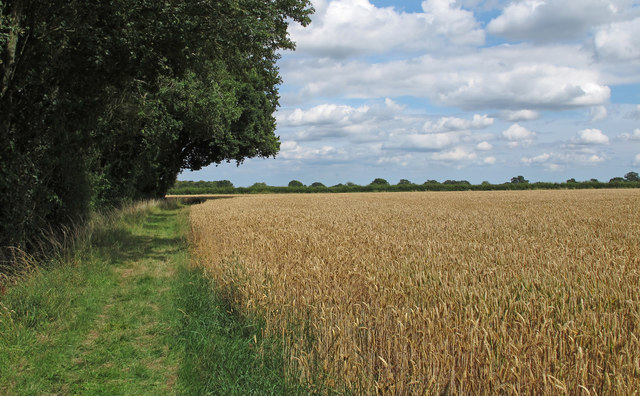
Wheat Field near Arger Fen, Bures
Weather for this location
Next 14 daysNearby places
Useful places within 5 km
Events & activities nearby
Switch provider to compare local events, tours and bookable activities.
Wildlife to spot
10,452 records · National Biodiversity Network
Wildlife to spot
10,452 records · National Biodiversity NetworkBlue Tit · Blackbird · Long-tailed Tit · Great Tit · Robin +43
- Blue TitCyanistes caeruleus
- BlackbirdTurdus merula
- Long-tailed TitAegithalos caudatus
- Great TitParus major
- RobinErithacus rubecula
- WoodpigeonColumba palumbus
- ChiffchaffPhylloscopus collybita
- WrenTroglodytes troglodytes
- JackdawColoeus monedula
- BlackcapSylvia atricapilla
- Green WoodpeckerPicus viridis
- Song ThrushTurdus philomelos
- SkylarkAlauda arvensis
- NuthatchSitta europaea
- Great Spotted WoodpeckerDendrocopos major
- JayGarrulus glandarius
- TreecreeperCerthia familiaris
- GoldcrestRegulus regulus
- Coal TitPeriparus ater
- RavenCorvus corax
- PeregrineFalco peregrinus
- Marsh TitPoecile palustris
- NightingaleLuscinia megarhynchos
- Carrion CrowCorvus corone
- LinnetLinaria cannabina
- Garden WarblerSylvia borin
- Reed BuntingEmberiza schoeniclus
- DunnockPrunella modularis
- WhitethroatCurruca communis
- KestrelFalco tinnunculus
- BullfinchPyrrhula pyrrhula
- SwallowHirundo rustica
- GreenfinchChloris chloris
- Stock DoveColumba oenas
- MerlinFalco columbarius
- ChaffinchFringilla coelebs
- RedwingTurdus iliacus
- HobbyFalco subbuteo
- YellowhammerEmberiza citrinella
- MoorhenGallinula chloropus
- GoldfinchCarduelis carduelis
- Red-legged PartridgeAlectoris rufa
- MagpiePica pica
- Mistle ThrushTurdus viscivorus
- PheasantPhasianus colchicus
- RookCorvus frugilegus
- Barn OwlTyto alba2024
- FieldfareTurdus pilaris2024
🦌Mammals2 species
springwinter
2025▾
Grey Squirrel · Muntjac
- Grey SquirrelSciurus carolinensis
- MuntjacMuntiacus reevesi
🐸Amphibians1 species
spring
2025▾
Common Toad
🐝Insects7 species
springsummer
2025▾
Common Blue Damselfly · 7-spot Ladybird · Migrant Hawker · Glow-worm · Phaonia valida +2
- Common Blue DamselflyEnallagma cyathigerum
- 7-spot LadybirdCoccinella septempunctata
- Migrant HawkerAeshna mixta
- Glow-wormLampyris noctiluca
- Phaonia validaPhaonia valida
- Dark-edged Bee-flyBombylius major
Wood Anemone · Goat Willow · Dog's Mercury · Yellow Archangel · Wood-sorrel +24
- Wood AnemoneAnemone nemorosa
- Goat WillowSalix caprea
- Dog's MercuryMercurialis perennis
- Yellow ArchangelLamiastrum galeobdolon2025
- Wood-sorrelOxalis acetosella2025
- Wood SpurgeEuphorbia amygdaloides2025
Species observations from the last 10 years via NBN Atlas
Orange Ladybird
Orange Ladybird
Halyzia sedecimguttata
Halyzia sedecimguttata
Greater Periwinkle
Greater Periwinkle
Vinca major
Vinca major
Alternate-leaved Golden-saxifrageChrysosplenium alternifoliumAlternate-leaved Golden-saxifrageChrysosplenium alternifoliumBluebellHyacinthoides non-scriptaBluebellHyacinthoides non-scriptaEarly Dog-violetViola reichenbachianaEarly Dog-violetViola reichenbachianaGreat HorsetailEquisetum telmateia2025Great HorsetailEquisetum telmateia2025QuinceCydonia oblonga2025QuinceCydonia oblonga2025Winter-cressBarbarea vulgaris2025Winter-cressBarbarea vulgaris2025Water AvensGeum rivale2025Water AvensGeum rivale2025PrimrosePrimula vulgaris2025PrimrosePrimula vulgaris2025PolypodyPolypodium vulgare2025PolypodyPolypodium vulgare2025HawthornCrataegus monogyna2025HawthornCrataegus monogyna2025Wild CherryPrunus avium2025Wild CherryPrunus avium2025HazelCorylus avellana2025HazelCorylus avellana2025Wild StrawberryFragaria vesca2025Wild StrawberryFragaria vesca2025HollyIlex aquifolium2025HollyIlex aquifolium2025Lords-and-LadiesArum maculatum2025Lords-and-LadiesArum maculatum2025RamsonsAllium ursinum2025RamsonsAllium ursinum2025IvyHedera helix2025IvyHedera helix2025Sweet VioletViola odorata2025Sweet VioletViola odorata2025Lesser CelandineFicaria verna2025Lesser CelandineFicaria verna2025Ground-ivyGlechoma hederacea2025Ground-ivyGlechoma hederacea2025Common NettleUrtica dioica2025Common NettleUrtica dioica2025CowslipPrimula veris2025CowslipPrimula veris2025