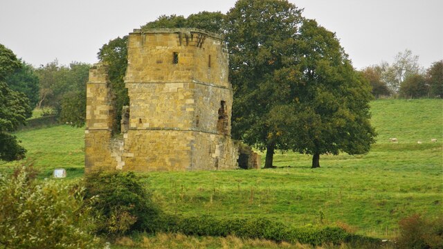
Ayton Castle: medieval manorial centre, fortified house including tower and fishponds
9 ha
Plan your visit
🦅Birds✦Heritage🦉Wildlife
Free entryDogs welcome9 ha
Getting here
54.25235, -0.48475
Open directionsv
Visiting this summer
Seasonal nature notes and what to look for now
- 🐦59+ species recorded in this area — summer evenings are best for activity; watch for Chaffinch and Great Tit
- ✦Historic character is a year-round quality here — summer brings its own atmosphere to the setting
- 🐕Dogs welcome — bring water in summer; the site has enough space to find shade on hot days
🌤️ Visiting this summer
- 🐦59+ species recorded in this area — summer evenings are best for activity; watch for Chaffinch and Great Tit
- ✦Historic character is a year-round quality here — summer brings its own atmosphere to the setting
- 🐕Dogs welcome — bring water in summer; the site has enough space to find shade on hot days
- £Free to visit — no entry charge
- 🐕Dogs welcome
🦅Bird watching
Very strong match
Birds — Chaffinch, Great Tit, Blue Tit +56 more · last seen 2025; Deciduous woodland — woodpeckers, warblers and woodland birds
Free
✦Heritage
Very strong match
Grade I listed building: AYTON CASTLE; Historic site
Free
Birds — Chaffinch, Great Tit, Blue Tit +56 more · last seen 2025; Deciduous woodland priority habitat
Free
🦋Insect spotting
Strong match
Insects — 10-spot Ladybird, Eristalis pertinax, Hawthorn Shieldbug +117 more · last seen 2026; Semi-improved grassland — butterflies and wildflowers
Free
🍂Seasonal nature
Strong match
Plants — Sanicle, Spurge-laurel, Wood Anemone +158 more · last seen 2026
Free
Deciduous woodland — fungi, berries and wild garlic
Varies
Trails nearby
Within roughly 5 km3 signed routes nearby
Signed route nearby
Cleveland WayWalking route▾
Named routePoint-to-pointNational walking route
King Charles III England Coast Path: Filey Brigg to North GareWalking route▾
Named routeRef ECPNational walking route
Tabular Hills WalkWalking route▾
Named routeRegional walking route
18 signed routes nearby
Signed route nearby
EuroVelo 12 - North Sea Cycle Route - part United Kingdom 3Cycling route▾
Lincoln - Whitby
Named routeRef EV12International cycle route
NCN 1 Humber to TeesCycling route▾
Named routeRef 1National Cycle Network
Main RouteCycling route35 m▾
Named routeRef 1Length 35 mNational Cycle NetworkTraffic-freeSurface asphalt
Main RouteCycling route361 m▾
Named routeRef 1Length 361 mNational Cycle NetworkTraffic-freeSurface asphalt
Main RouteCycling route170 m▾
Named routeRef 1Length 170 mNational Cycle NetworkOn-roadSurface asphalt
Main RouteCycling route92 m▾
Named routeRef 1Length 92 mNational Cycle NetworkTraffic-freeSurface asphalt
1 signed route nearby
Signed route nearby
Moors to SeaMountain bike route▾
3 public paths nearby
Public paths
Seavegate Gillbridleway · 43 m▾
Public pathbridlewayLength 43 mPath type: track
Seavegate Gillbridleway · 420 m▾
Public pathbridlewayLength 420 mPath type: bridleway
Weather for this location
Next 14 daysNearby places
Useful places within 5 km
Events & activities nearby
Switch provider to compare local events, tours and bookable activities.
Wildlife to spot
12,108 records · National Biodiversity Network
Wildlife to spot
12,108 records · National Biodiversity NetworkMole · Brown Rat · Badger
- MoleTalpa europaea
- Brown RatRattus norvegicus2025
- BadgerMeles meles2025
7-spot Ladybird · Black Clock · Leistus spinibarbis · Harlequin Ladybird · Hawthorn Shieldbug +15
- 7-spot LadybirdCoccinella septempunctata
- Black ClockPterostichus madidus2025
- Leistus spinibarbisLeistus spinibarbis2025
- Harlequin LadybirdHarmonia axyridis
- Hawthorn ShieldbugAcanthosoma haemorrhoidale
- Juniper ShieldbugCyphostethus tristriatus
Spurge-laurel · Hazel · Beech · Daisy · Pedunculate Oak +111
- Spurge-laurelDaphne laureola
- HazelCorylus avellana
- BeechFagus sylvatica
- DaisyBellis perennis
- Pedunculate OakQuercus robur
- Ribwort PlantainPlantago lanceolata
- Red FescueFestuca rubra
Species observations from the last 10 years via NBN Atlas