Plan your visit
🦉 Wildlife🦅 Birds✦ Heritage
Public access Free entry Dogs welcome 11 ha
Places › England › South East › Vale of White Horse Getting here
51.57163, -1.21249
Open directionsv ✦ Scheduled Ancient Monument — Nationally protected archaeological site on the National Heritage List for England (NHLE). Scheduled monuments represent the best surviving examples of England's irreplaceable archaeological heritage.
Archaeological site scheduled monument
Visiting this summer
Seasonal nature notes and what to look for now
▾ ☀️ June — long evenings and clear skies; one of the most rewarding months for a late visit ✦ Historic character is a year-round quality here — summer brings its own atmosphere to the setting 🐕 Dogs welcome — bring water in summer; the site has enough space to find shade on hot days 🌤️ Visiting this summer
☀️ June — long evenings and clear skies; one of the most rewarding months for a late visit ✦ Historic character is a year-round quality here — summer brings its own atmosphere to the setting 🐕 Dogs welcome — bring water in summer; the site has enough space to find shade on hot days £ Free to visit — no entry charge🐕 Dogs welcome🦉 Wildlife
Very strong match
Multi-group wildlife — Amphibians, Birds, Mammals, Reptiles; Multi-group wildlife — Amphibians, Birds, Mammals, Reptiles
Free
🦅 Bird watching
Very strong match
Birds — Quail, Wren, Goldfinch +53 more · last seen 2025; Birds — Quail, Wren, Goldfinch +53 more · last seen 2025
Free
Historic site with public access
Free
🦋 Insect spotting
Strong match
Chalk and limestone grassland — chalkhill blue, adonis blue and rare moths; Insects — Cinnabar, Turnip Moth, Shuttle-shaped Dart +299 more · last seen 2026
Free
Dogs allowed with public access
Free
Deciduous woodland — fungi, berries and wild garlic
Varies
Trails nearby Within roughly 5 km 7 signed routes nearby · 9 public paths nearby
Signed route nearby Public paths
The Ridgeway Walking route 140 km ▾
Named route Ref RW Length 140 km National walking route
Show on map The Roman Way Walking route 274.5 km ▾
Named route Length 274.5 km Regional walking route
Show on map European walking route E2 west, UK, South East England Walking route ▾
Westroute: Stranraer (UK) - Birminhgham (UK) - Calais (FR) - Zoersel (BE) / Eastroute: Stranraer (UK) - Harwich (UK) - Rotterdam (NL) - Zoersel (BE) / Both Routes: Zoersel (BE) - Maastrich (NL) - Luxembourg (LUX) - Lake Geneva (CH) - Nice (FR)
Named route Ref E2 International walking route
Show on map Hanson Way Walking route ▾
West Berkshire Countryside Walk, Goring Gap Walking route 11.2 km ▾
Enjoy this circular spanning Lardon Chase, the Holies & Lough Down. Explore a variety of landscapes, spot rare butterflies & admire views of the Chiltern Hills, North Wessex Downs & Goring Gap. Sections may be challenging for people with reduced mobility.
Named route Length 11.2 km Duration 03:30 Round trip Local walking route
Show on map 47 signed routes nearby
Signed route nearby
National Cycle Network Route 5 Cycling route ▾
Named route Ref 5 National Cycle Network
Show on map Round Berkshire Cycle Route Cycling route ▾
Named route Regional cycle route
Show on map Route 544 Cycling route ▾
Named route Ref 544 National Cycle Network
Show on map Didcot to Culham Science Centre Cycling route ▾
Named route Ref 8 Local cycle route
Show on map Didcot to Milton Park Cycling route ▾
Named route Ref 6 Local cycle route
Show on map Didcot to Harwell Campus Cycling route ▾
Named route Ref 5 Local cycle route
Show on map 1 signed route nearby
Signed route nearby
King Alfred's Way Mountain bike route ▾
King Alfreds Way is 350km (220 miles) off road route designed to be ridden clockwise. It starts & ends in Winchester. It is suitable for gravel or cross-country bikes.
Named route Regional cycle route
Show on map 7 public paths nearby
Public paths
No named routes yet. Public paths are shown on the map.
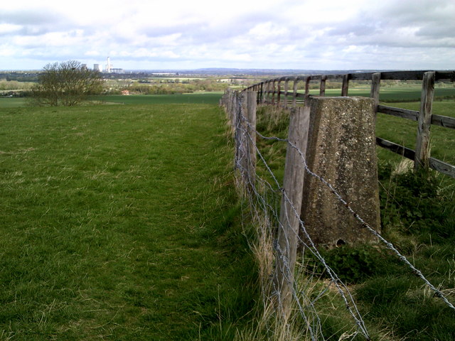
Photos Trig point on Blewburton Hill
‹ ›
Weather for this location Next 14 days Nearby places Useful places within 5 km
All Historic
How useful was the information on this page?
id: 33442b4e-c981-4579-af73-10c21c64ed4b
UK green spaces mapped from open public data — so anyone can find the woodland, trail, or nature reserve closest to them.
© 2026 Glade · Made with care for UK green spaces
Wildlife to spot
37,476 records · National Biodiversity Network
▾
Wildlife to spot 37,476 records · National Biodiversity Network Rook · Magpie · Woodpigeon · Blackbird · Black-headed Gull +32
Rook Corvus frugilegus Magpie Pica pica Woodpigeon Columba palumbus Blackbird Turdus merula Black-headed Gull Chroicocephalus ridibundus Robin Erithacus rubecula Chaffinch Fringilla coelebs Goldfinch Carduelis carduelis Wren Troglodytes troglodytes Blue Tit Cyanistes caeruleus Jackdaw Coloeus monedula Great Tit Parus major Little Egret Egretta garzetta Stock Dove Columba oenas Starling Sturnus vulgaris Fieldfare Turdus pilaris Redwing Turdus iliacus Pied Wagtail Motacilla alba yarrellii Lesser Black-backed Gull Larus fuscus Pheasant Phasianus colchicus Long-tailed Tit Aegithalos caudatus Dunnock Prunella modularis Moorhen Gallinula chloropus Carrion Crow Corvus corone Greylag Goose Anser anser Goldcrest Regulus regulus Lapwing Vanellus vanellus Greenfinch Chloris chloris Common Gull Larus canus Reed Bunting Emberiza schoeniclus Yellowhammer Emberiza citrinella Mallard Anas platyrhynchos Mistle Thrush Turdus viscivorus Collared Dove Streptopelia decaocto Grey Heron Ardea cinerea Song Thrush Turdus philomelos Siskin Spinus spinus Wood Mouse · Harvest Mouse · Roe Deer · Hedgehog
Wood Mouse Apodemus sylvaticus Harvest Mouse Micromys minutus Roe Deer Capreolus capreolus Hedgehog Erinaceus europaeus 🐸 Amphibians 1 species
autumn
2025 ▾
Newt
Light Brown Apple Moth · Red-green Carpet · Turnip Moth · White-point · Black Rustic +56
Light Brown Apple Moth Epiphyas postvittana Red-green Carpet Chloroclysta siterata2025 Turnip Moth Agrotis segetum2025 White-point Mythimna albipuncta2025 Black Rustic Aporophyla nigra2025 Double-striped Pug Gymnoscelis rufifasciata Species observations from the last 10 years via NBN Atlas
Large Yellow Underwing Noctua pronuba2025
Large Yellow Underwing Noctua pronuba2025
Common Quaker Orthosia cerasi
Common Quaker Orthosia cerasi
Barred Sallow Tiliacea aurago2025
Barred Sallow Tiliacea aurago2025
Common Marbled Carpet Dysstroma truncata2025
Common Marbled Carpet Dysstroma truncata2025
Beaded Chestnut Agrochola lychnidis2025
Beaded Chestnut Agrochola lychnidis2025
Hebrew Character Orthosia gothica
Hebrew Character Orthosia gothica
Clouded Drab Orthosia incerta
Clouded Drab Orthosia incerta
Oak Beauty Biston strataria
Oak Beauty Biston strataria
Twin-spotted Quaker Anorthoa munda
Twin-spotted Quaker Anorthoa munda
December Moth Poecilocampa populi2025
December Moth Poecilocampa populi2025
Shuttle-shaped Dart Agrotis puta2025
Shuttle-shaped Dart Agrotis puta2025
Rusty Dot Udea ferrugalis2025
Rusty Dot Udea ferrugalis2025
Cypress Carpet Thera cupressata2025
Cypress Carpet Thera cupressata2025
Sprawler Asteroscopus sphinx2025
Sprawler Asteroscopus sphinx2025
Silver Y Autographa gamma2025
Silver Y Autographa gamma2025
Merveille du Jour Griposia aprilina2025
Merveille du Jour Griposia aprilina2025
Vine's Rustic Hoplodrina ambigua2025
Vine's Rustic Hoplodrina ambigua2025
Spruce Carpet Thera britannica2025
Spruce Carpet Thera britannica2025
Rush Veneer Nomophila noctuella2025
Rush Veneer Nomophila noctuella2025
Lesser Yellow Underwing Noctua comes2025
Lesser Yellow Underwing Noctua comes2025
Common Pug Eupithecia vulgata
Common Pug Eupithecia vulgata
March Moth Alsophila aescularia
March Moth Alsophila aescularia
Brindled Beauty Lycia hirtaria
Brindled Beauty Lycia hirtaria
Small Quaker Orthosia cruda
Small Quaker Orthosia cruda
Early Grey Xylocampa areola
Early Grey Xylocampa areola
Dotted Border Agriopis marginaria
Dotted Border Agriopis marginaria
Chestnut Conistra vaccinii
Chestnut Conistra vaccinii
Scarce Umber Agriopis aurantiaria2025
Scarce Umber Agriopis aurantiaria2025
Dark-streaked Tortrix Acleris umbrana2025
Dark-streaked Tortrix Acleris umbrana2025
Satellite Eupsilia transversa2025
Satellite Eupsilia transversa2025
Winter Moth Operophtera brumata2025
Winter Moth Operophtera brumata2025
White-shouldered House-moth Endrosis sarcitrella2025
White-shouldered House-moth Endrosis sarcitrella2025
Dark Chestnut Conistra ligula2025
Dark Chestnut Conistra ligula2025
Rosy Tabby Endotricha flammealis2025
Rosy Tabby Endotricha flammealis2025
Green-brindled Crescent Allophyes oxyacanthae2025
Green-brindled Crescent Allophyes oxyacanthae2025
Oak Rustic Dryobota labecula2025
Oak Rustic Dryobota labecula2025
Epirrita Epirrita2025
Epirrita Epirrita2025
Feathered Thorn Colotois pennaria2025
Feathered Thorn Colotois pennaria2025
November Moth agg. Epirrita dilutata agg.2025
November Moth agg. Epirrita dilutata agg.2025
Delicate Mythimna vitellina2025
Delicate Mythimna vitellina2025
Herald Scoliopteryx libatrix2025
Herald Scoliopteryx libatrix2025
Angle Shades Phlogophora meticulosa2025
Angle Shades Phlogophora meticulosa2025
Figure of Eight Diloba caeruleocephala2025
Figure of Eight Diloba caeruleocephala2025
Brimstone Moth Opisthograptis luteolata2025
Brimstone Moth Opisthograptis luteolata2025
Red-Line Quaker Leptologia lota2025
Red-Line Quaker Leptologia lota2025
Long-horned Flat-body Carcina quercana2025
Long-horned Flat-body Carcina quercana2025
Willow Beauty Peribatodes rhomboidaria2025
Willow Beauty Peribatodes rhomboidaria2025
L-album Wainscot Mythimna l-album2025
L-album Wainscot Mythimna l-album2025
Rugged Oil-beetle Meloe rugosus2025
Rugged Oil-beetle Meloe rugosus2025
Geotrupes mutator Geotrupes mutator2025
Geotrupes mutator Geotrupes mutator2025
Narrow-winged Grey Eudonia angustea2025
Narrow-winged Grey Eudonia angustea2025
Sallow Cirrhia icteritia2025
Sallow Cirrhia icteritia2025
Broad-bordered Yellow Underwing Noctua fimbriata2025
Broad-bordered Yellow Underwing Noctua fimbriata2025
Box Tree Moth Cydalima perspectalis2025
Box Tree Moth Cydalima perspectalis2025
Clancy's Rustic Caradrina kadenii2025
Clancy's Rustic Caradrina kadenii2025 Events & activities nearby Switch provider to compare local events, tours and bookable activities.
Bookable tours