Bokerley Dyke, and a section of Grim's Ditch, a section of a medieval boundary bank, and two bowl barrows on and north west of Martin Down 18 ha
Plan your visit
🦅 Birds🦉 Wildlife✦ Heritage
Public access Free entry Dogs welcome 18 ha
Getting here
50.96798, -1.93499
Open directionsv ✦ Scheduled Ancient Monument — Nationally protected archaeological site on the National Heritage List for England (NHLE). Scheduled monuments represent the best surviving examples of England's irreplaceable archaeological heritage.
Archaeological site scheduled monument
Visiting this summer
Seasonal nature notes and what to look for now
▾ 🐦 74+ species recorded in this area — summer evenings are best for activity; watch for Carrion Crow and Robin ✦ Historic character is a year-round quality here — summer brings its own atmosphere to the setting 🐕 Dogs welcome — bring water in summer; the site has enough space to find shade on hot days 🌤️ Visiting this summer
🐦 74+ species recorded in this area — summer evenings are best for activity; watch for Carrion Crow and Robin ✦ Historic character is a year-round quality here — summer brings its own atmosphere to the setting 🐕 Dogs welcome — bring water in summer; the site has enough space to find shade on hot days £ Free to visit — no entry charge🐕 Dogs welcome🦅 Bird watching
Very strong match
Birds — Carrion Crow, Robin, Woodpigeon +71 more · last seen 2025; Deciduous woodland — woodpeckers, warblers and woodland birds
Free
Birds — Carrion Crow, Robin, Woodpigeon +71 more · last seen 2025; Deciduous woodland priority habitat
Free
Historic site with public access
Free
🦋 Insect spotting
Strong match
Chalk and limestone grassland — chalkhill blue, adonis blue and rare moths; Insects — Meliscaeva auricollis, Eristalis pertinax, Dark-edged Bee-fly +3 more · last seen 2026
Free
🍂 Seasonal nature
Strong match
Plants — Megapolitan Feather-moss, Curly Crisp-moss, Hornschuch's Beard-moss +66 more · last seen 2026
Free
Dogs allowed with public access
Free
Trails nearby Within roughly 5 km 4 signed routes nearby · 3 public paths nearby
Signed route nearby Public paths
Cranborne Droves Way Walking route ▾
The route of the Cranborne Droves Way walkers route between Win Green where it links with Wessex Ridgeway and Salisbury where it links with the Sarsen Way
Named route Regional walking route
Show on map Shire Rack Walking route ▾
Path following the Dorset-Wiltshire border
Named route
Show on map Jubilee Trail (Dorset) Walking route ▾
Named route Regional walking route
Show on map The Hardy Way Walking route ▾
Named route Regional walking route
Show on map 1 signed route nearby
Signed route nearby
National Byway Cycling route ▾
Named route Ref NB Regional cycle route
Show on map 3 signed routes nearby
Signed route nearby
Fordingbridge Off Road Cycle Trail Mountain bike route ▾
Fordingbridge Off Road Cycle Trail (Shortcut) Mountain bike route ▾
Cranborne Droves Way Trail Mountain bike route ▾
44 public paths nearby
Public paths
Earthpits Lane restricted byway · 813 m ▾
Public path restricted byway Length 813 m Surface ground Path type: track
Show on map Bowling Green Lane restricted byway · 1.3 km ▾
Public path restricted byway Length 1.3 km Surface ground Path type: track
Show on map Townsend Lane bridleway · 303 m ▾
Public path bridleway Length 303 m Path type: bridleway
Show on map Townsend Lane bridleway · 321 m ▾
Public path bridleway Length 321 m Surface grass Path type: track
Show on map Bowling Green Lane restricted byway · 224 m ▾
Public path restricted byway Length 224 m Path type: track
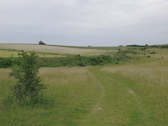
Show on map Photos Sighting WNW along Bokerley Dyke, from Martin Down National Nature Reserve
‹ ›
Weather for this location Next 14 days Nearby places Useful places within 5 km
All Historic
UK green spaces mapped from open public data — so anyone can find the woodland, trail, or nature reserve closest to them.
© 2026 Glade · Made with care for UK green spaces
Wildlife to spot
77,158 records · National Biodiversity Network
▾
Wildlife to spot 77,158 records · National Biodiversity Network Redwing · Woodpigeon · Starling · Fieldfare · Robin +38
Redwing Turdus iliacus Woodpigeon Columba palumbus Starling Sturnus vulgaris Fieldfare Turdus pilaris Robin Erithacus rubecula Wren Troglodytes troglodytes Kestrel Falco tinnunculus Carrion Crow Corvus corone Meadow Pipit Anthus pratensis Long-tailed Tit Aegithalos caudatus Magpie Pica pica Mistle Thrush Turdus viscivorus Jackdaw Coloeus monedula Greenfinch Chloris chloris Yellowhammer Emberiza citrinella Jay Garrulus glandarius Corn Bunting Emberiza calandra Raven Corvus corax Coal Tit Periparus ater Herring Gull Larus argentatus Collared Dove Streptopelia decaocto Blackbird Turdus merula Great Tit Parus major Goldfinch Carduelis carduelis Song Thrush Turdus philomelos Chaffinch Fringilla coelebs Bullfinch Pyrrhula pyrrhula Dunnock Prunella modularis Goldcrest Regulus regulus Skylark Alauda arvensis Rook Corvus frugilegus Grey Wagtail Motacilla cinerea House Sparrow Passer domesticus Stock Dove Columba oenas Grey Heron Ardea cinerea Pied Wagtail Motacilla alba yarrellii Pheasant Phasianus colchicus Black-headed Gull Chroicocephalus ridibundus Blackcap Sylvia atricapilla Linnet Linaria cannabina Great Black-backed Gull Larus marinus Blue Tit Cyanistes caeruleus Lesser Black-backed Gull Larus fuscus Meliscaeva auricollis · Eristalis pertinax · Dark-edged Bee-fly
Meliscaeva auricollis Meliscaeva auricollis Eristalis pertinax Eristalis pertinax Dark-edged Bee-fly Bombylius major Megapolitan Feather-moss · Hornschuch's Beard-moss · Curly Crisp-moss · Clustered Feather-moss · Great Plait-moss +58
Megapolitan Feather-moss Rhynchostegium megapolitanum Hornschuch's Beard-moss Pseudocrossidium hornschuchianum Curly Crisp-moss Trichostomum crispulum Clustered Feather-moss Rhynchostegium confertum Great Plait-moss Hypnum cupressiforme var. lacunosum Pointed Spear-moss Calliergonella cuspidata Species observations from the last 10 years via NBN Atlas
Fox-tail Feather-moss Thamnobryum alopecurum
Fox-tail Feather-moss Thamnobryum alopecurum
Springy Turf-moss Rhytidiadelphus squarrosus
Springy Turf-moss Rhytidiadelphus squarrosus
Wood Bristle-moss Lewinskya affinis
Wood Bristle-moss Lewinskya affinis
Appleyard's Feather-moss Scleropodium cespitans
Appleyard's Feather-moss Scleropodium cespitans
Common Striated Feather-moss Eurhynchium striatum
Common Striated Feather-moss Eurhynchium striatum
Even Scalewort Radula complanata
Even Scalewort Radula complanata
Rock Pocket-moss Fissidens dubius
Rock Pocket-moss Fissidens dubius
Wall Thread-moss Bryum radiculosum
Wall Thread-moss Bryum radiculosum
Montagne's Cylinder-moss Entodon concinnus
Montagne's Cylinder-moss Entodon concinnus
Common Pocket-moss Fissidens taxifolius
Common Pocket-moss Fissidens taxifolius
Silky Wall Feather-moss Homalothecium sericeum
Silky Wall Feather-moss Homalothecium sericeum
Neat Feather-moss Pseudoscleropodium purum
Neat Feather-moss Pseudoscleropodium purum
Chalk Rock-bristle Seligeria calcarea
Chalk Rock-bristle Seligeria calcarea
Lateral Cryphaea Cryphaea heteromalla
Lateral Cryphaea Cryphaea heteromalla
Creeping Feather-moss Amblystegium serpens
Creeping Feather-moss Amblystegium serpens
Zygodon conoideus var. conoideus Zygodon conoideus var. conoideus
Zygodon conoideus var. conoideus Zygodon conoideus var. conoideus
Minute Pouncewort Myriocoleopsis minutissima
Minute Pouncewort Myriocoleopsis minutissima
Chalk Comb-moss Ctenidium molluscum
Chalk Comb-moss Ctenidium molluscum
Park Yoke-moss Zygodon rupestris
Park Yoke-moss Zygodon rupestris
Common Aloe-moss Aloina aloides
Common Aloe-moss Aloina aloides
Whitish Feather-moss Brachythecium albicans
Whitish Feather-moss Brachythecium albicans
Elegant Bristle-moss Orthotrichum pulchellum
Elegant Bristle-moss Orthotrichum pulchellum
Syntrichia montana var. montana Syntrichia montana var. montana
Syntrichia montana var. montana Syntrichia montana var. montana
Slender Ditrichum Flexitrichum gracile
Slender Ditrichum Flexitrichum gracile
Wall Screw-moss Tortula muralis
Wall Screw-moss Tortula muralis
English Rock-bristle Seligeria calycina
English Rock-bristle Seligeria calycina
Round-fruited Pottia Pottiopsis caespitosa
Round-fruited Pottia Pottiopsis caespitosa
Lyell's Bristle-moss Pulvigera lyellii
Lyell's Bristle-moss Pulvigera lyellii
Bruch's Pincushion Ulota bruchii
Bruch's Pincushion Ulota bruchii
Rough-stalked Feather-moss Brachythecium rutabulum
Rough-stalked Feather-moss Brachythecium rutabulum
Many-fruited Thyme-moss Plagiomnium affine
Many-fruited Thyme-moss Plagiomnium affine
Yellow Feather-moss Homalothecium lutescens
Yellow Feather-moss Homalothecium lutescens
White-tipped Bristle-moss Orthotrichum diaphanum
White-tipped Bristle-moss Orthotrichum diaphanum
Small Hairy Screw-moss Syntrichia laevipila
Small Hairy Screw-moss Syntrichia laevipila
Bendy Ditrichum Flexitrichum flexicaule
Bendy Ditrichum Flexitrichum flexicaule
Capillary Thread-moss Bryum capillare
Capillary Thread-moss Bryum capillare
Weissia brachycarpa var. obliqua Weissia brachycarpa var. obliqua
Weissia brachycarpa var. obliqua Weissia brachycarpa var. obliqua
Top Notchwort Mesoptychia turbinata
Top Notchwort Mesoptychia turbinata
Crisped Neckera Neckera crispa
Crisped Neckera Neckera crispa
Supine Plait-moss Hypnum cupressiforme var. resupinatum
Supine Plait-moss Hypnum cupressiforme var. resupinatum
Slender Bristle-moss Orthotrichum tenellum
Slender Bristle-moss Orthotrichum tenellum
Redshank Ceratodon purpureus
Redshank Ceratodon purpureus
Thickpoint Grimmia Schistidium crassipilum
Thickpoint Grimmia Schistidium crassipilum
Fallacious Beard-moss Didymodon fallax
Fallacious Beard-moss Didymodon fallax
Dusky Beard-moss Didymodon luridus
Dusky Beard-moss Didymodon luridus
Forked Veilwort Metzgeria furcata
Forked Veilwort Metzgeria furcata
Tender Feather-moss Rhynchostegiella tenella
Tender Feather-moss Rhynchostegiella tenella
Tall Pottia Tortula protobryoides
Tall Pottia Tortula protobryoides
Golden Feather-moss Campylium chrysophyllum
Golden Feather-moss Campylium chrysophyllum
Isothecium myosuroides Isothecium myosuroides
Isothecium myosuroides Isothecium myosuroides
Grey-cushioned Grimmia Grimmia pulvinata
Grey-cushioned Grimmia Grimmia pulvinata
Twisting Thread-moss Bryum torquescens
Twisting Thread-moss Bryum torquescens
Campylium protensum Campylium protensum
Campylium protensum Campylium protensum
Crisped Fork-moss Dicranum bonjeanii
Crisped Fork-moss Dicranum bonjeanii
Common Feather-moss Kindbergia praelonga
Common Feather-moss Kindbergia praelonga
Dicranella howei Dicranella howei
Dicranella howei Dicranella howei
Dilated Scalewort Frullania dilatata
Dilated Scalewort Frullania dilatata Events & activities nearby Switch provider to compare local events, tours and bookable activities.
Bookable tours GetYourGuide Tripadvisor