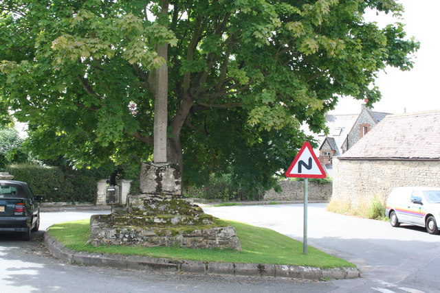
Bourton village cross 0 ha
🦉 Wildlife🦅 Birds🦋 Insects
↑ Share
Free entry Dogs welcome 0 ha
Places › England › South East › Vale of White Horse Getting here
51.58117, -1.66654
Open directionsv ✦ Scheduled Ancient Monument — Nationally protected archaeological site on the National Heritage List for England (NHLE). Scheduled monuments represent the best surviving examples of England's irreplaceable archaeological heritage.
Market cross scheduled monument
Visiting this summer
Seasonal nature notes and what to look for now
▾ 🌞 Midsummer — early morning visits most comfortable; look for deer fawns in quieter clearings 🌿 Foraging is at its best in summer here 🐕 Dogs welcome — bring water in summer; the site has enough space to find shade on hot days 🌤️ Visiting this summer
🌞 Midsummer — early morning visits most comfortable; look for deer fawns in quieter clearings 🌿 Foraging is at its best in summer here 🐕 Dogs welcome — bring water in summer; the site has enough space to find shade on hot days £ Free to visit — no entry charge🐕 Dogs welcome🦉 Wildlife
Very strong match
Multi-group wildlife — Amphibians, Birds, Mammals, Reptiles; Multi-group wildlife — Amphibians, Birds, Mammals, Reptiles
Free
🦅 Bird watching
Very strong match
Birds — Robin, Blackbird, Dunnock +60 more · last seen 2025; Birds — Robin, Blackbird, Dunnock +60 more · last seen 2025
Free
🦋 Insect spotting
Strong match
Insects — Orange-tip, Green-veined White, Large White +68 more · last seen 2025; Insects — Orange-tip, Green-veined White, Large White +68 more · last seen 2025
Free
🍂 Seasonal nature
Strong match
Plants — Common Nettle, Ribwort Plantain, Elder +189 more · last seen 2021; Plants — Common Nettle, Ribwort Plantain, Elder +189 more · last seen 2021
Free
Plants — Common Nettle, Elder, Hogweed +16 more foraging species
Varies
Trails nearby Within roughly 5 km 7 signed routes nearby · 13 public paths nearby
Signed route nearby Public paths
The Ridgeway Walking route 140 km ▾
Named route Ref RW Length 140 km National walking route
Show on map D'Arcy Dalton Way Walking route 107 km ▾
Follows roughly the western boundary of Oxfordshire in unspoilt countryside.
Named route Length 107 km Regional walking route
Show on map The Roman Way Walking route 274.5 km ▾
Named route Length 274.5 km Regional walking route
Show on map The Vale Way Walking route 43 km ▾
Route through the Vale of White Horse in Oxfordshire, UK. (27 miles).
Named route Length 43 km Local walking route
Show on map The Cole and its Landscape (Formerly the Red Walk: Coleshill) Walking route 6.4 km ▾
Follow red way markers on this circular flat route through the Coleshill Estate. Some tracks and footpaths may be muddy and uneven, especially after rain. There are a number of stiles, gates and a small footbridge.
Named route Length 6.4 km Duration 02:00 Round trip Local walking route
Show on map 5 signed routes nearby
Signed route nearby
Eastern Flyer Cycling route ▾
Named route Ref EF Local cycle route
Show on map Swindon to Ridgeway Link Cycling route ▾
Named route Local cycle route
Show on map Vale Cycle Links Cycling route ▾
Urban Round Cycling route 27 km ▾
Named route Ref UR Length 27 km Round trip Local cycle route
Show on map Dorcan Round Cycling route 11.3 km ▾
Named route Ref DR Length 11.3 km Round trip Local cycle route
Show on map 1 signed route nearby
Signed route nearby
King Alfred's Way Mountain bike route ▾
King Alfreds Way is 350km (220 miles) off road route designed to be ridden clockwise. It starts & ends in Winchester. It is suitable for gravel or cross-country bikes.
Named route Regional cycle route
Show on map 2 public paths nearby
Public paths
Steppingstone Lane bridleway · 124 m ▾
Public path bridleway Length 124 m Path type: residential
Show on map Steppingstone Lane bridleway · 199 m ▾
Public path bridleway Length 199 m Path type: track
Show on map Photos A historic pinnacle in the centre of Bourton village
‹ ›
Weather for this location Next 14 days Nearby places Useful places within 5 km
All Historic
Own or manage this place?
Claim this listing to keep details accurate, add photos, and highlight what makes it special — free.
Claim this page→ How useful was the information on this page?
Something wrong on this page?
id: a9dc0c2c-818f-450f-a1cc-b7dd117f210c
UK green spaces mapped from open public data — so anyone can find the woodland, trail, or nature reserve closest to them.
© 2026 Glade · Made with care for UK green spaces
Wildlife to spot
2,949 records · National Biodiversity Network
▾
Wildlife to spot 2,949 records · National Biodiversity Network 🐦 Birds 43 species
spring summer
2025 ▾
Robin · Blackbird · Dunnock · Jackdaw · Wren +38
Robin Erithacus rubecula Blackbird Turdus merula Dunnock Prunella modularis Jackdaw Coloeus monedula Wren Troglodytes troglodytes Redwing Turdus iliacus2024 Blue Tit Cyanistes caeruleus2023 Starling Sturnus vulgaris Woodpigeon Columba palumbus Kestrel Falco tinnunculus2023 Goldfinch Carduelis carduelis2021 Swift Apus apus Carrion Crow Corvus corone2022 Song Thrush Turdus philomelos2021 Rook Corvus frugilegus Collared Dove Streptopelia decaocto Fieldfare Turdus pilaris2024 Chaffinch Fringilla coelebs2023 Great Tit Parus major2021 House Sparrow Passer domesticus2021 Skylark Alauda arvensis Yellowhammer Emberiza citrinella2023 Chiffchaff Phylloscopus collybita2023 Bullfinch Pyrrhula pyrrhula Swallow Hirundo rustica Raven Corvus corax Goldcrest Regulus regulus2024 Barn Owl Tyto alba2023 Greenfinch Chloris chloris2021 Herring Gull Larus argentatus Black-headed Gull Chroicocephalus ridibundus Jack Snipe Lymnocryptes minimus2023 Grey Heron Ardea cinerea2023 Meadow Pipit Anthus pratensis2023 Willow Warbler Phylloscopus trochilus2023 Nuthatch Sitta europaea2023 Mistle Thrush Turdus viscivorus2022 Linnet Linaria cannabina2021 Pied Wagtail Motacilla alba2021 Reed Bunting Emberiza schoeniclus2021 Blackcap Sylvia atricapilla2021 Whitethroat Curruca communis2021 Great Spotted Woodpecker Dendrocopos major2021 🦌 Mammals 2 species
winter spring
2025 ▾
Brown Hare · Red Fox
Brown Hare Lepus europaeus Red Fox Vulpes vulpes2022 Common Lizard
Common Lizard Zootoca vivipara 🐸 Amphibians 1 species
spring
2022 ▾
Common Frog
Common Frog Rana temporaria Swollen-thighed Beetle · Common Rose Fusehorn · Dock Bug · Beautiful Demoiselle · Large Yellow Underwing +30
Swollen-thighed Beetle Oedemera nobilis2024 Common Rose Fusehorn Arge pagana2023 Dock Bug Coreus marginatus2022 Beautiful Demoiselle Calopteryx virgo Large Yellow Underwing Noctua pronuba2024 Buff Ermine Spilosoma lutea Species observations from the last 10 years via NBN Atlas
2024
2024
Black Arches Lymantria monacha2024
Black Arches Lymantria monacha2024
Swallow Prominent Pheosia tremula2024
Swallow Prominent Pheosia tremula2024
Lesser Swallow Prominent Pheosia gnoma2024
Lesser Swallow Prominent Pheosia gnoma2024
Dingy Footman Eilema griseola2024
Dingy Footman Eilema griseola2024
Ruby Tiger Phragmatobia fuliginosa2024
Ruby Tiger Phragmatobia fuliginosa2024
Dark-edged Bee-fly Bombylius major2024
Dark-edged Bee-fly Bombylius major2024
Sphaerophoria scripta Sphaerophoria scripta2023
Sphaerophoria scripta Sphaerophoria scripta2023
Square-spot Rustic Xestia xanthographa2023
Square-spot Rustic Xestia xanthographa2023
Sphaerophoria Sphaerophoria2023
Sphaerophoria Sphaerophoria2023
Sarcophaga Sarcophaga2023
Sarcophaga Sarcophaga2023
Hairy Shieldbug Dolycoris baccarum2023
Hairy Shieldbug Dolycoris baccarum2023
Syrphus Syrphus2023
Syrphus Syrphus2023
Phasia obesa Phasia obesa2023
Phasia obesa Phasia obesa2023
Burnet Companion Euclidia glyphica2023
Burnet Companion Euclidia glyphica2023
Volucella bombylans Volucella bombylans2023
Volucella bombylans Volucella bombylans2023
Mother Shipton Callistege mi2023
Mother Shipton Callistege mi2023
Broad-bodied Chaser Libellula depressa2023
Broad-bodied Chaser Libellula depressa2023
Beautiful Plume Amblyptilia acanthadactyla2022
Beautiful Plume Amblyptilia acanthadactyla2022
Alder Leaf Beetle Agelastica alni2022
Alder Leaf Beetle Agelastica alni2022
Xylota Xylota2022
Xylota Xylota2022
Scarlet Tiger Callimorpha dominula2022
Scarlet Tiger Callimorpha dominula2022
Large Red Damselfly Pyrrhosoma nymphula2022
Large Red Damselfly Pyrrhosoma nymphula2022
Harmonia axyridis form succinea Harmonia axyridis form succinea2022
Harmonia axyridis form succinea Harmonia axyridis form succinea2022
Pyrausta Pyrausta2022
Pyrausta Pyrausta2022
Yellow-barred Long-horn Nemophora degeerella2022
Yellow-barred Long-horn Nemophora degeerella2022
Dolichovespula media Dolichovespula media2022
Dolichovespula media Dolichovespula media2022
Eristalis pertinax Eristalis pertinax2022
Eristalis pertinax Eristalis pertinax2022
Small Green Nettle Weevil Phyllobius roboretanus2021
Small Green Nettle Weevil Phyllobius roboretanus2021
Conocephalus Conocephalus2021
Conocephalus Conocephalus2021 Events & activities nearby Switch provider to compare local events, tours and bookable activities.
Bookable tours GetYourGuide Promote here