Half Crown Wood - Broadleaved woodland
4 ha
🧺Picnic🐶Dogs🛝Family
Public accessFree entryDogs welcome4 ha
Getting here
52.34078, -2.28827
Open directionsv
Visiting this summer
Seasonal nature notes and what to look for now
- 🌞Midsummer — early morning visits most comfortable; look for deer fawns in quieter clearings
- 🧺Good picnic destination in summer — open space and facilities for a relaxed day out
- 🛝Playground 285m away — built-in entertainment for younger visitors alongside the wider site
🌤️ Visiting this summer
- 🌞Midsummer — early morning visits most comfortable; look for deer fawns in quieter clearings
- 🧺Good picnic destination in summer — open space and facilities for a relaxed day out
- 🛝Playground 285m away — built-in entertainment for younger visitors alongside the wider site
- £Free to visit — no entry charge
- 🐕Dogs welcome
🚲Bike parking🅿️Parking· Paid🧺Picnic spot🛝Playground
🧺Picnic day out
Strong match
picnic area, car park
Free
Dogs allowed — public woodland
Free
🛝Family friendly
Strong match
playground, picnic area
Free
Traditional orchard — seasonal fruit, fungi and wild plants
Varies
Deciduous woodland priority habitat
Free
Trails nearby
Within roughly 5 km7 signed routes nearby · 12 public paths nearby
Signed route nearbyPublic paths
North Worcestershire PathWalking route▾
Named routeRegional walking route
Worcestershire WayWalking route50 km▾
Walking route from Bewdley to Great Malvern
Named routeLength 50 kmRegional walking route
Geopark WayWalking route175 km▾
Named routeRef geoLength 175 kmRegional walking route
Ribbesford Circular TrailWalking route2 km▾
Named routeRef RCTLength 2 kmLocal walking route
Abberley Circular WalkWalking route5 km▾
Named routeLength 5 kmLocal walking route
Sion Gardenspublic footpath · 38 m▾
Public pathpublic footpathLength 38 mSurface asphaltPath type: footway
73 signed routes nearby
Signed route nearby
Mercian WayCycling route▾
Named routeRef 45National Cycle Network
Route 54Cycling route▾
Named routeRef 54National Cycle Network
Route 4Cycling route▾
Named routeRef 4Local cycle route
Route 49Cycling route▾
Named routeRef 49Regional cycle route
Main RouteCycling route995 m▾
Named routeRef 45Length 995 mNational Cycle NetworkOn-roadSurface asphalt
Main RouteCycling route22 m▾
Named routeRef 45Length 22 mNational Cycle NetworkOn-roadSurface asphalt
Photos
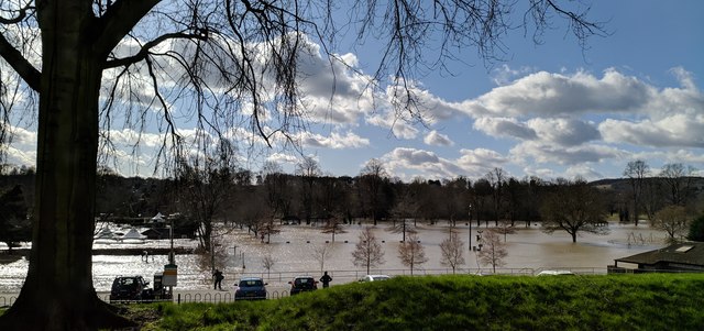
Floods in Stourport on Severn 2020
Weather for this location
Next 14 daysNearby places
Useful places within 5 km
Own or manage this place?
Claim this listing to keep details accurate, add photos, and highlight what makes it special — free.
Claim this page→How useful was the information on this page?
id: 59e5d465-63b0-455a-b290-ae382d44fe01
Events & activities nearby
Switch provider to compare local events, tours and bookable activities.
Wildlife to spot
21,442 records · National Biodiversity Network
Wildlife to spot
21,442 records · National Biodiversity NetworkStarling · Marsh Tit · Grey Heron · Mute Swan · Green Woodpecker +35
- StarlingSturnus vulgaris
- Marsh TitPoecile palustris
- Grey HeronArdea cinerea
- Mute SwanCygnus olor
- Green WoodpeckerPicus viridis
- StonechatSaxicola rubicola
- House SparrowPasser domesticus
- Reed WarblerAcrocephalus scirpaceus
- SwiftApus apus
- TreecreeperCerthia familiaris
- Collared DoveStreptopelia decaocto
- Lesser RedpollAcanthis flammea cabaret2024
- BlackbirdTurdus merula2024
- Meadow PipitAnthus pratensis2024
- Blue TitCyanistes caeruleus2024
- BullfinchPyrrhula pyrrhula2024
- MoorhenGallinula chloropus2024
- RedwingTurdus iliacus2024
- Pied WagtailMotacilla alba yarrellii2024
- Water RailRallus aquaticus2024
- DunnockPrunella modularis2024
- Long-tailed TitAegithalos caudatus2024
- JayGarrulus glandarius2024
- Grey WagtailMotacilla cinerea2024
- FieldfareTurdus pilaris2024
- Carrion CrowCorvus corone2024
- MallardAnas platyrhynchos2024
- WrenTroglodytes troglodytes2024
- ChaffinchFringilla coelebs2024
- Black-headed GullChroicocephalus ridibundus2024
- MagpiePica pica2024
- RobinErithacus rubecula2024
- Lesser Black-backed GullLarus fuscus2024
- WoodpigeonColumba palumbus2024
- SiskinSpinus spinus2024
- Herring GullLarus argentatus2024
- GoldfinchCarduelis carduelis2024
- GoldcrestRegulus regulus2024
- CormorantPhalacrocorax carbo2024
- Tawny OwlStrix aluco2024
🦌Mammals4 species
winterspringsummerautumn
2026▾
Pipistrelle Bat species · Badger · Roe Deer · Rabbit
- Pipistrelle Bat speciesPipistrellus
- BadgerMeles meles2025
- Roe DeerCapreolus capreolus2025
- RabbitOryctolagus cuniculus2025
🦎Reptiles2 species
springautumn
2025▾
Slow-worm · Common Lizard
- Slow-wormAnguis fragilis
- Common LizardZootoca vivipara
🐸Amphibians3 species
springautumn
2026▾
Great Crested Newt · Common Frog · Common Toad
- Great Crested NewtTriturus cristatus2025
- Common FrogRana temporaria
- Common ToadBufo bufo2025
🐝Insects71 species
springsummerautumn
2025▾
Common Darter · Azure Damselfly · Large Red Damselfly · Four-spotted Chaser · Broad-bodied Chaser +66
- Common DarterSympetrum striolatum
- Azure DamselflyCoenagrion puella
- Large Red DamselflyPyrrhosoma nymphula
- Four-spotted ChaserLibellula quadrimaculata
- Broad-bodied ChaserLibellula depressa
- Emperor Dragonfly
Species observations from the last 10 years via NBN Atlas
Anax imperator
Anax imperator
Migrant HawkerAeshna mixta2024Migrant HawkerAeshna mixta2024Southern HawkerAeshna cyaneaSouthern HawkerAeshna cyaneaYellow MayflyPotamanthus luteusYellow MayflyPotamanthus luteusBanded DemoiselleCalopteryx splendensBanded DemoiselleCalopteryx splendensBlue-tailed DamselflyIschnura elegansBlue-tailed DamselflyIschnura elegansWestern Conifer Seed BugLeptoglossus occidentalisWestern Conifer Seed BugLeptoglossus occidentalisRuddy DarterSympetrum sanguineumRuddy DarterSympetrum sanguineumRed-legged ShieldbugPentatoma rufipesRed-legged ShieldbugPentatoma rufipesRed-eyed DamselflyErythromma najasRed-eyed DamselflyErythromma najasSmall Red-eyed DamselflyErythromma viridulum2024Small Red-eyed DamselflyErythromma viridulum2024Brown HawkerAeshna grandis2024Brown HawkerAeshna grandis2024Scathophaga stercorariaScathophaga stercorariaScathophaga stercorariaScathophaga stercorariaBaccha elongataBaccha elongataBaccha elongataBaccha elongataHydropsyche siltalaiHydropsyche siltalaiHydropsyche siltalaiHydropsyche siltalaiGlyphotaelius pellucidusGlyphotaelius pellucidusGlyphotaelius pellucidusGlyphotaelius pellucidusHydroptilidaeHydroptilidaeHydroptilidaeHydroptilidaeLimnephilus lunatusLimnephilus lunatusLimnephilus lunatusLimnephilus lunatusAgrayleaAgrayleaAgrayleaAgrayleaParent BugElasmucha griseaParent BugElasmucha griseaHairy ShieldbugDolycoris baccarumHairy ShieldbugDolycoris baccarumKite-tailed RobberflyMachimus atricapillusKite-tailed RobberflyMachimus atricapillusLeptoceridaeLeptoceridaeLeptoceridaeLeptoceridaeCommon EarwigForficula auricularia/dentata agg.Common EarwigForficula auricularia/dentata agg.Field GrasshopperChorthippus brunneusField GrasshopperChorthippus brunneusRhinoceros BeetleSinodendron cylindricumRhinoceros BeetleSinodendron cylindricumGreater Bulb-FlyMerodon equestrisGreater Bulb-FlyMerodon equestrisGarden ChaferPhyllopertha horticolaGarden ChaferPhyllopertha horticolaLimnephilus rhombicusLimnephilus rhombicusLimnephilus rhombicusLimnephilus rhombicusHairy DragonflyBrachytron pratenseHairy DragonflyBrachytron pratenseSicus ferrugineusSicus ferrugineusSicus ferrugineusSicus ferrugineusChrysotoxum cautumChrysotoxum cautumChrysotoxum cautumChrysotoxum cautum16-spot LadybirdTytthaspis sedecimpunctata16-spot LadybirdTytthaspis sedecimpunctataCommon Club-tailGomphus vulgatissimusCommon Club-tailGomphus vulgatissimusAlydus calcaratusAlydus calcaratusAlydus calcaratusAlydus calcaratusHydropsycheHydropsycheHydropsycheHydropsycheJuniper ShieldbugCyphostethus tristriatusJuniper ShieldbugCyphostethus tristriatusHairy-legged HorseflyHybomitra bimaculataHairy-legged HorseflyHybomitra bimaculataBlack-headed Cardinal BeetlePyrochroa coccineaBlack-headed Cardinal BeetlePyrochroa coccineaSwollen-thighed BeetleOedemera nobilisSwollen-thighed BeetleOedemera nobilisEpistrophe eligansEpistrophe eligansEpistrophe eligansEpistrophe eligansForget-me-not ShieldbugSehirus luctuosusForget-me-not ShieldbugSehirus luctuosusHarpalus affinisHarpalus affinisHarpalus affinisHarpalus affinisRhopalus (Rhopalus) subrufusRhopalus (Rhopalus) subrufusRhopalus (Rhopalus) subrufusRhopalus (Rhopalus) subrufusAthous haemorrhoidalisAthous haemorrhoidalisAthous haemorrhoidalisAthous haemorrhoidalisGrammotaulius nigropunctatusGrammotaulius nigropunctatusGrammotaulius nigropunctatusGrammotaulius nigropunctatusHelophilus hybridusHelophilus hybridusHelophilus hybridusHelophilus hybridusRed Mason BeeOsmia bicornisRed Mason BeeOsmia bicornisGreen Tiger BeetleCicindela campestrisGreen Tiger BeetleCicindela campestrisDotted Bee-flyBombylius discolorDotted Bee-flyBombylius discolorAndrion regensteinenseAndrion regensteinenseAndrion regensteinenseAndrion regensteinenseBloody-nosed BeetleTimarcha tenebricosaBloody-nosed BeetleTimarcha tenebricosaGronops lunatusGronops lunatusGronops lunatusGronops lunatusBibio lanigerusBibio lanigerusBibio lanigerusBibio lanigerusDark-edged Bee-flyBombylius majorDark-edged Bee-flyBombylius majorMeliscaeva auricollisMeliscaeva auricollisMeliscaeva auricollisMeliscaeva auricollisMesembrina meridianaMesembrina meridiana2024Mesembrina meridianaMesembrina meridiana2024Dark Bush-cricketPholidoptera griseoaptera2024Dark Bush-cricketPholidoptera griseoaptera2024Ivy BeeColletes hederae2024Ivy BeeColletes hederae2024Tipula paludosaTipula paludosa2024Tipula paludosaTipula paludosa2024Common Blue DamselflyEnallagma cyathigerum2024Common Blue DamselflyEnallagma cyathigerum2024Birch ShieldbugElasmostethus interstinctus2024Birch ShieldbugElasmostethus interstinctus2024Scaeva pyrastriScaeva pyrastri2024Scaeva pyrastriScaeva pyrastri2024Aquarius paludumAquarius paludum2024Aquarius paludumAquarius paludum2024Anoplotrupes stercorosusAnoplotrupes stercorosus2024Anoplotrupes stercorosusAnoplotrupes stercorosus2024Acrossus rufipesAcrossus rufipes2024Acrossus rufipesAcrossus rufipes2024