Lever Park - Broadleaved woodland
1 ha
🐶Dogs🦉Wildlife🦅Birds
Public accessFree entryDogs welcome1 ha
Getting here
53.60823, -2.54493
Open directionsv
Visiting this summer
Seasonal nature notes and what to look for now
- 🌞Midsummer — early morning visits most comfortable; look for deer fawns in quieter clearings
- 🐕Early mornings are best for dog walks in summer — visit before 9am to avoid the heat and find quieter trails
- 📍Open access throughout summer — no booking required
🌤️ Visiting this summer
- 🌞Midsummer — early morning visits most comfortable; look for deer fawns in quieter clearings
- 🐕Early mornings are best for dog walks in summer — visit before 9am to avoid the heat and find quieter trails
- 📍Open access throughout summer — no booking required
- £Free to visit — no entry charge
- 🐕Dogs welcome
Dogs allowed — public woodland
Free
Deciduous woodland priority habitat
Free
🦅Bird watching
Strong match
Deciduous woodland — woodpeckers, warblers and woodland birds
Free
Deciduous woodland — fungi, berries and wild garlic
Varies
Named hiking route nearby: GM Ringway Stage 14
Free
Trails nearby
Within roughly 5 km6 signed routes nearby · 11 public paths nearby
Signed route nearbyPublic paths
Full walk - Witton Weavers WayWalking route▾
Rotary WayWalking route▾
Named routeLocal walking route
GM Ringway Stage 14Walking route21.9 km▾
GM Ringway Stage 14 - Bromley Cross to Blackrod
Named routeLength 21.9 kmRegional walking route
GM Ringway Stage 15Walking route16.2 km▾
GM Ringway Stage 15 - Blackrod to Wigan
Named routeLength 16.2 kmRegional walking route
Wigan WayWalking route▾
37 signed routes nearby
Signed route nearby
Regional Route 80Cycling route▾
Named routeRegional cycle route
Chorley LoopCycling route▾
Named routeRef Chorley LoopLocal cycle route
Lancashire Cycleway (Southern Loop)Cycling route▾
Named routeRef 91Regional cycle route
Route 55Cycling route▾
Named routeRef 55National Cycle Network
Greater Manchester Route 80Cycling route▾
Named routeRef 80Regional cycle route
N/ACycling route382 m▾
Named routeRef 80Length 382 mNational Cycle NetworkOn-roadSurface asphalt
7 public paths nearby
Public paths
Roynton Roadbridleway · 108 m▾
Public pathbridlewayLength 108 mPath type: unclassified
Roynton Roadbridleway · 290 m▾
Public pathbridlewayLength 290 mPath type: unclassified
Roynton Lanebridleway · 339 m▾
Public pathbridlewayLength 339 mSurface unpavedPath type: bridleway
Roynton Roadbridleway · 10 m▾
Public pathbridlewayLength 10 mPath type: unclassified
Photos
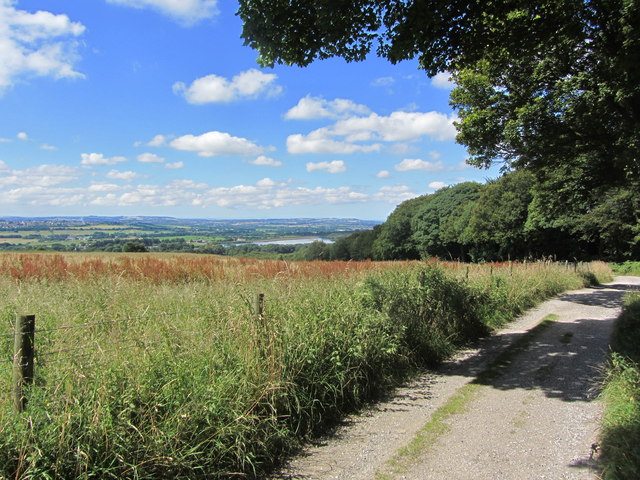
Track below Ormstons Farm with view towards Lower Rivington Reservoir
Weather for this location
Next 14 daysNearby places
Useful places within 5 km
Own or manage this place?
Claim this listing to keep details accurate, add photos, and highlight what makes it special — free.
Claim this page→How useful was the information on this page?
id: 8fa7d92e-c13a-4b7a-85cf-a178b8235cac
Pipistrellus pygmaeus2025
Pipistrellus pygmaeus2025
BadgerMeles meles2025BadgerMeles meles2025Green Dock BeetleGastrophysa viridulaGreen Dock BeetleGastrophysa viridulaEarly BumblebeeBombus pratorumEarly BumblebeeBombus pratorumBlack DarterSympetrum danaeBlack DarterSympetrum danaeBanded DemoiselleCalopteryx splendensBanded DemoiselleCalopteryx splendensMelanostoma scalareMelanostoma scalareMelanostoma scalareMelanostoma scalareCicadella viridisCicadella viridisCicadella viridisCicadella viridisBlue-tailed DamselflyIschnura elegansBlue-tailed DamselflyIschnura elegansCuckoo-Spit InsectPhilaenus spumariusCuckoo-Spit InsectPhilaenus spumariusCantharis decipiensCantharis decipiensCantharis decipiensCantharis decipiensVolucella bombylansVolucella bombylansVolucella bombylansVolucella bombylansCantharis nigricansCantharis nigricansCantharis nigricansCantharis nigricansSpotted-winged DrosophilaDrosophila suzukiiSpotted-winged DrosophilaDrosophila suzukiiGraphopsocus cruciatusGraphopsocus cruciatusGraphopsocus cruciatusGraphopsocus cruciatusRed-legged ShieldbugPentatoma rufipesRed-legged ShieldbugPentatoma rufipesBirch ShieldbugElasmostethus interstinctusBirch ShieldbugElasmostethus interstinctusTriplax aeneaTriplax aeneaTriplax aeneaTriplax aeneaCommon HawkerAeshna junceaCommon HawkerAeshna junceaEupeodesEupeodesEupeodesEupeodesPeacockAglais ioPeacockAglais ioAzure DamselflyCoenagrion puellaAzure DamselflyCoenagrion puellaField Digger WaspArgogorytes mystaceusField Digger WaspArgogorytes mystaceusChalcosyrphus nemorumChalcosyrphus nemorumChalcosyrphus nemorumChalcosyrphus nemorumSericomyia lapponaSericomyia lapponaSericomyia lapponaSericomyia lapponaLarge Red DamselflyPyrrhosoma nymphulaLarge Red DamselflyPyrrhosoma nymphulaSnail HunterCychrus caraboidesSnail HunterCychrus caraboidesRhagium mordaxRhagium mordaxRhagium mordaxRhagium mordaxPhaonia signataPhaonia signataPhaonia signataPhaonia signataCommon Carder BeeBombus pascuorumCommon Carder BeeBombus pascuorumPlatycheirusPlatycheirusPlatycheirusPlatycheirusSphaerophoriaSphaerophoriaSphaerophoriaSphaerophoriaMeliscaeva auricollisMeliscaeva auricollisMeliscaeva auricollisMeliscaeva auricollisBroad CenturionChloromyia formosaBroad CenturionChloromyia formosaBaccha elongataBaccha elongataBaccha elongataBaccha elongataEristalis tenaxEristalis tenaxEristalis tenaxEristalis tenaxSilver-Green Leaf WeevilPhyllobius argentatusSilver-Green Leaf WeevilPhyllobius argentatusBlack SnipeflyChrysopilus cristatusBlack SnipeflyChrysopilus cristatusMelanostomaMelanostomaMelanostomaMelanostomaRivellia syngenesiaeRivellia syngenesiaeRivellia syngenesiaeRivellia syngenesiaeWater CricketVelia (Plesiovelia) capraiWater CricketVelia (Plesiovelia) capraiNebria brevicollisNebria brevicollisNebria brevicollisNebria brevicollisChrysotoxum arcuatumChrysotoxum arcuatumChrysotoxum arcuatumChrysotoxum arcuatumTree BumblebeeBombus hypnorumTree BumblebeeBombus hypnorumWelsh Poppy
Welsh Poppy
Papaver cambricum2025
Papaver cambricum2025
Common RagwortJacobaea vulgaris2025Common RagwortJacobaea vulgaris2025HollyIlex aquifoliumHollyIlex aquifoliumRhododendronRhododendron ponticum2025RhododendronRhododendron ponticum2025Wood AvensGeum urbanum2025Wood AvensGeum urbanum2025Yorkshire-fogHolcus lanatus2025Yorkshire-fogHolcus lanatus2025RowanSorbus aucuparia2025RowanSorbus aucuparia2025Downy BirchBetula pubescens2025Downy BirchBetula pubescens2025Creeping ButtercupRanunculus repens2025Creeping ButtercupRanunculus repens2025ShallonGaultheria shallon2025ShallonGaultheria shallon2025Enchanter's-nightshadeCircaea lutetiana2025Enchanter's-nightshadeCircaea lutetiana2025HeatherCalluna vulgaris2025HeatherCalluna vulgaris2025BeechFagus sylvatica2025BeechFagus sylvatica2025SycamoreAcer pseudoplatanus2025SycamoreAcer pseudoplatanus2025BilberryVaccinium myrtillusBilberryVaccinium myrtillusHart's-TongueAsplenium scolopendriumHart's-TongueAsplenium scolopendriumBrackenPteridium aquilinumBrackenPteridium aquilinumHerb-RobertGeranium robertianum2025Herb-RobertGeranium robertianum2025Broad-leaved DockRumex obtusifolius2025Broad-leaved DockRumex obtusifolius2025White CloverTrifolium repens2025White CloverTrifolium repens2025Taxus baccata f. baccataTaxus baccata f. baccata2025Taxus baccata f. baccataTaxus baccata f. baccata2025Soft-rushJuncus effusus2025Soft-rushJuncus effusus2025Red CloverTrifolium pratense2025Red CloverTrifolium pratense2025Creeping ThistleCirsium arvense2025Creeping ThistleCirsium arvense2025Broad-leaved WillowherbEpilobium montanum2025Broad-leaved WillowherbEpilobium montanum2025Sweet Vernal-grassAnthoxanthum odoratum2025Sweet Vernal-grassAnthoxanthum odoratum2025SelfhealPrunella vulgaris2025SelfhealPrunella vulgaris2025Marsh ThistleCirsium palustre2025Marsh ThistleCirsium palustre2025Japanese KnotweedReynoutria japonica2025Japanese KnotweedReynoutria japonica2025Lady-fernAthyrium filix-femina2025Lady-fernAthyrium filix-femina2025Crested Dog's-tailCynosurus cristatus2025Crested Dog's-tailCynosurus cristatus2025GorseUlex europaeusGorseUlex europaeusRed CampionSilene dioica2025Red CampionSilene dioica2025DaisyBellis perennisDaisyBellis perennisSpear ThistleCirsium vulgareSpear ThistleCirsium vulgareWild CarrotDaucus carota2025Wild CarrotDaucus carota2025Broad-leaved HelleborineEpipactis helleborine2025Broad-leaved HelleborineEpipactis helleborine2025Greater PlantainPlantago major2025Greater PlantainPlantago major2025Ribwort PlantainPlantago lanceolata2025Ribwort PlantainPlantago lanceolata2025Cock's-footDactylis glomerata2025Cock's-footDactylis glomerata2025Maidenhair SpleenwortAsplenium trichomanes2025Maidenhair SpleenwortAsplenium trichomanes2025ElderSambucus nigra2025ElderSambucus nigra2025Fox-and-cubsPilosella aurantiaca2025Fox-and-cubsPilosella aurantiaca2025Great WillowherbEpilobium hirsutum2025Great WillowherbEpilobium hirsutum2025Centaurea nigraCentaurea nigra2025Centaurea nigraCentaurea nigra2025Ivy-leaved ToadflaxCymbalaria muralis2025Ivy-leaved ToadflaxCymbalaria muralis2025Rubus dasyphyllusRubus dasyphyllus2025Rubus dasyphyllusRubus dasyphyllus2025Arrow BambooPseudosasa japonica2025Arrow BambooPseudosasa japonica2025Narrow-leaved VetchVicia sativa subsp. nigra2025Narrow-leaved VetchVicia sativa subsp. nigra2025Wild CherryPrunus avium2025Wild CherryPrunus avium2025Wood-sorrelOxalis acetosella2025Wood-sorrelOxalis acetosella2025AshFraxinus excelsior2025AshFraxinus excelsior2025Male-fernDryopteris filix-mas2025Male-fernDryopteris filix-mas2025Red FescueFestuca rubra2025Red FescueFestuca rubra2025Yellow-rattleRhinanthus minor2025Yellow-rattleRhinanthus minor2025Meadow FoxtailAlopecurus pratensis2025Meadow FoxtailAlopecurus pratensis2025Hare's-tail CottongrassEriophorum vaginatumHare's-tail CottongrassEriophorum vaginatumDarwin's BarberryBerberis darwiniiDarwin's BarberryBerberis darwiniiHimalayan BalsamImpatiens glanduliferaHimalayan BalsamImpatiens glanduliferaRedshankPersicaria maculosa2025RedshankPersicaria maculosa2025BulrushTypha latifolia2025BulrushTypha latifolia2025Common Spotted-orchidDactylorhiza fuchsii2025Common Spotted-orchidDactylorhiza fuchsii2025Cat's-earHypochaeris radicata2025Cat's-earHypochaeris radicata2025Highclere HollyIlex aquifolium x perado = I. x altaclerensis2025Highclere HollyIlex aquifolium x perado = I. x altaclerensis2025Horse-chestnutAesculus hippocastanum2025Horse-chestnutAesculus hippocastanum2025Sheep's SorrelRumex acetosella2025Sheep's SorrelRumex acetosella2025Lesser TrefoilTrifolium dubium2025Lesser TrefoilTrifolium dubium2025Copper BeechFagus sylvatica group 'Atropurpurea'2025Copper BeechFagus sylvatica group 'Atropurpurea'2025Scots PinePinus sylvestris2025Scots PinePinus sylvestris2025CuckooflowerCardamine pratensis2025CuckooflowerCardamine pratensis2025Fern-leaf YarrowAchillea filipendulina2025Fern-leaf YarrowAchillea filipendulina2025PolypodyPolypodium vulgarePolypodyPolypodium vulgareLove-in-a-mistNigella damascena2025Love-in-a-mistNigella damascena2025NasturtiumTropaeolum majus2025NasturtiumTropaeolum majus2025Wild MarjoramOriganum vulgare2025Wild MarjoramOriganum vulgare2025Fodder BurnetPoterium sanguisorba subsp. balearicum2025Fodder BurnetPoterium sanguisorba subsp. balearicum2025Wood HorsetailEquisetum sylvaticum2025Wood HorsetailEquisetum sylvaticum2025SneezewortAchillea ptarmica2025SneezewortAchillea ptarmica2025Water MintMentha aquatica2025Water MintMentha aquatica2025MeadowsweetFilipendula ulmaria2025MeadowsweetFilipendula ulmaria2025BrooklimeVeronica beccabunga2025BrooklimeVeronica beccabunga2025Red BartsiaOdontites vernus2025Red BartsiaOdontites vernus2025Carpet BoxPachysandra terminalis2025Carpet BoxPachysandra terminalis2025Common CentauryCentaurium erythraea2025Common CentauryCentaurium erythraea2025Field ScabiousKnautia arvensis2025Field ScabiousKnautia arvensis2025Tufted VetchVicia cracca2025Tufted VetchVicia cracca2025Meadow VetchlingLathyrus pratensis2025Meadow VetchlingLathyrus pratensis2025Japanese RoseRosa rugosa2025Japanese RoseRosa rugosa2025Cross-leaved HeathErica tetralix2025Cross-leaved HeathErica tetralix2025Oxeye DaisyLeucanthemum vulgare2025Oxeye DaisyLeucanthemum vulgare2025ShoreweedLittorella uniflora2025ShoreweedLittorella uniflora2025Meadow ButtercupRanunculus acris2025Meadow ButtercupRanunculus acris2025BayLaurus nobilis2025BayLaurus nobilis2025ColumbineAquilegia vulgaris2025ColumbineAquilegia vulgaris2025Rusty WillowSalix cinerea subsp. oleifolia2025Rusty WillowSalix cinerea subsp. oleifolia2025Cherry PlumPrunus cerasifera var. pissardii2025Cherry PlumPrunus cerasifera var. pissardii2025HornbeamCarpinus betulus2025HornbeamCarpinus betulus2025Intermediate PolypodyPolypodium interjectum2025Intermediate PolypodyPolypodium interjectum2025Broad-leaved BambooSasa palmata2025Broad-leaved BambooSasa palmata2025Wall-rueAsplenium ruta-muraria2025Wall-rueAsplenium ruta-muraria2025YewTaxus baccata2025YewTaxus baccata2025Bush VetchVicia sepium2025Bush VetchVicia sepium2025CleaversGalium aparine2025CleaversGalium aparine2025Heath BedstrawGalium saxatile2025Heath BedstrawGalium saxatile2025Lawson CypressCupressus lawsoniana2025Lawson CypressCupressus lawsoniana2025Opium PoppyPapaver somniferum2025Opium PoppyPapaver somniferum2025Opposite-leaved Golden-saxifrageChrysosplenium oppositifolium2025Opposite-leaved Golden-saxifrageChrysosplenium oppositifolium2025AppleMalus domestica2025AppleMalus domestica2025Pedunculate OakQuercus robur2025Pedunculate OakQuercus robur2025Wild StrawberryFragaria vesca2025Wild StrawberryFragaria vesca2025HogweedHeracleum sphondylium2025HogweedHeracleum sphondylium2025Annual Meadow-grassPoa annua2025Annual Meadow-grassPoa annua2025Sweet ChestnutCastanea sativa2025Sweet ChestnutCastanea sativa2025Antarctic BeechNothofagus antarctica2025Antarctic BeechNothofagus antarctica2025TurnipBrassica rapa2025TurnipBrassica rapa2025Prickly Sow-thistleSonchus asper2025Prickly Sow-thistleSonchus asper2025Lodgepole PinePinus contorta2025Lodgepole PinePinus contorta2025Curled DockRumex crispus2025Curled DockRumex crispus2025HawthornCrataegus monogyna2025HawthornCrataegus monogyna2025Garlic MustardAlliaria petiolata2025Garlic MustardAlliaria petiolata2025Common SorrelRumex acetosa2025Common SorrelRumex acetosa2025Rough Meadow-grassPoa trivialis2025Rough Meadow-grassPoa trivialis2025Russian ComfreySymphytum asperum x officinale = S. x uplandicum2025Russian ComfreySymphytum asperum x officinale = S. x uplandicum2025PignutConopodium majus2025PignutConopodium majus2025Common Bird's-foot-trefoilLotus corniculatus2025Common Bird's-foot-trefoilLotus corniculatus2025Remote SedgeCarex remota2025Remote SedgeCarex remota2025Events & activities nearby
Switch provider to compare local events, tours and bookable activities.