Greenhill Moor Plantation - Broadleaved woodland
2 ha
🐶Dogs🦉Wildlife🦅Birds
Public accessFree entryDogs welcome2 ha
Getting here
53.31394, -1.46869
Open directionsv
Visiting this summer
Seasonal nature notes and what to look for now
- 🌞Midsummer — early morning visits most comfortable; look for deer fawns in quieter clearings
- 🐕Early mornings are best for dog walks in summer — visit before 9am to avoid the heat and find quieter trails
- 🅿️Parking 431m away — 4 car parks within reach
🌤️ Visiting this summer
- 🌞Midsummer — early morning visits most comfortable; look for deer fawns in quieter clearings
- 🐕Early mornings are best for dog walks in summer — visit before 9am to avoid the heat and find quieter trails
- 🅿️Parking 431m away — 4 car parks within reach
- £Free to visit — no entry charge
- 🐕Dogs welcome
Dogs allowed — public woodland
Free
Deciduous woodland priority habitat
Free
🦅Bird watching
Strong match
Deciduous woodland — woodpeckers, warblers and woodland birds
Free
Deciduous woodland — fungi, berries and wild garlic
Varies
Named hiking route nearby: Sheffield Country Walk
Free
Trails nearby
Within roughly 5 km15 signed routes nearby · 13 public paths nearby
Signed route nearbyPublic paths
Chesterfield Round WalkWalking route▾
Named routeRound tripLocal walking route
Sheffield Round WalkWalking route▾
Named routeRef SRW
Peak District Boundary Walk Stage 11Walking route17 km▾
Named routeLength 17 kmRegional walking route
Sheffield Country WalkWalking route85 km▾
Named routeLength 85 kmRegional walking route
GHB Ward WalkWalking route▾
Cross Lanepublic footpath · 178 m▾
Public pathpublic footpathLength 178 mSurface gravelPath type: service
Pighills Lanepublic footpath · 115 m▾
Public pathpublic footpathLength 115 mSurface gravelPath type: track
Pighills Lanepublic footpath · 229 m▾
Public pathpublic footpathLength 229 mSurface gravelPath type: track
6 signed routes nearby
Signed route nearby
Norfolk Park Cycling RouteCycling route▾
Named routeRef Norfolk ParkLocal cycle route
Sheffield Local Cycle NetworkCycling route▾
Sheffield Local Cycle Network
Named routeLocal cycle route
N/ACycling route161 m▾
Named routeLength 161 mNational Cycle NetworkTraffic-freeSurface unsealedloose
N/ACycling route13 m▾
Named routeLength 13 mNational Cycle NetworkTraffic-freeSurface asphalt
N/ACycling route167 m▾
Named routeLength 167 mNational Cycle NetworkTraffic-freeSurface unsealedfirm
N/ACycling route120 m▾
Named routeLength 120 mNational Cycle NetworkTraffic-freeSurface asphalt
Photos
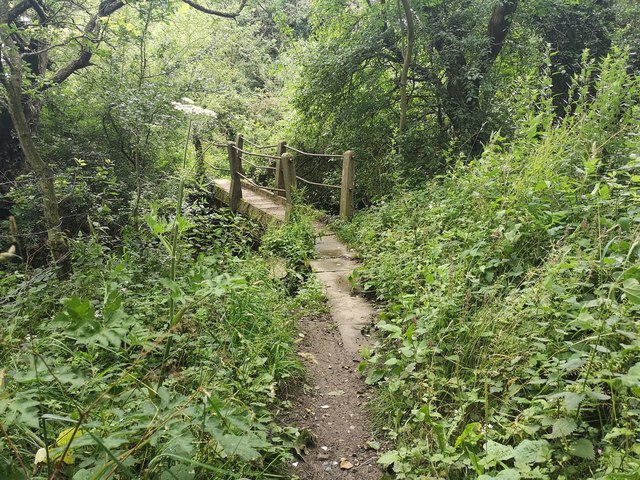
Footbridge near Holmefield Farm
Weather for this location
Next 14 daysNearby places
Useful places within 5 km
Own or manage this place?
Claim this listing to keep details accurate, add photos, and highlight what makes it special — free.
Claim this page→How useful was the information on this page?
id: e349703a-cf72-4f34-be37-48e61b2d1479
Events & activities nearby
Switch provider to compare local events, tours and bookable activities.
Wildlife to spot
22,630 records · National Biodiversity Network
Wildlife to spot
22,630 records · National Biodiversity Network🐦Birds29 species
wintersummer
2026▾
Blackbird · Magpie · Woodpigeon · Robin · Blue Tit +24
- BlackbirdTurdus merula
- MagpiePica pica
- WoodpigeonColumba palumbus
- RobinErithacus rubecula
- Blue TitCyanistes caeruleus
- ChaffinchFringilla coelebs
- GoldcrestRegulus regulus
- House SparrowPasser domesticus
- Pied WagtailMotacilla alba
- TreecreeperCerthia familiaris2025
- Great Spotted WoodpeckerDendrocopos major
- DunnockPrunella modularis
- Collared DoveStreptopelia decaocto
- WrenTroglodytes troglodytes2025
- Great TitParus major
- Black-headed GullChroicocephalus ridibundus
- JackdawColoeus monedula
- NuthatchSitta europaea
- RedwingTurdus iliacus
- Lesser Black-backed GullLarus fuscus2025
- Song ThrushTurdus philomelos2025
- ChiffchaffPhylloscopus collybita2025
- BlackcapSylvia atricapilla2025
- GoldfinchCarduelis carduelis
- StarlingSturnus vulgaris
- Herring GullLarus argentatus2025
- Tawny OwlStrix aluco2025
- SwiftApus apus2025
- Carrion CrowCorvus corone2025
Hedgehog · Roe Deer · Badger
- HedgehogErinaceus europaeus
- Roe DeerCapreolus capreolus
- BadgerMeles meles
🐸Amphibians2 species
summerautumn
2025▾
Smooth Newt · Common Frog
- Smooth NewtLissotriton vulgaris
- Common FrogRana temporaria
Harlequin Ladybird · Red-legged Shieldbug · Marmalade Hoverfly · Green Shieldbug · Cuckoo-Spit Insect +23
- Harlequin LadybirdHarmonia axyridis2025
- Red-legged ShieldbugPentatoma rufipes2025
- Marmalade HoverflyEpisyrphus balteatus2025
- Green ShieldbugPalomena prasina2025
- Cuckoo-Spit InsectPhilaenus spumarius2025
- Sphaerophoria
Hairy Curtain Crust · Leafy Brain · Witch's Butter · Trametes
- Hairy Curtain CrustStereum hirsutum
- Leafy BrainPhaeotremella foliacea
- Witch's ButterExidia glandulosa
- TrametesTrametes
🌿Plants31 species
wintersummer
2026▾
Lesser Celandine · Snowdrop · Bittersweet · Speedwell · Early Dog-violet +26
- Lesser CelandineFicaria verna
- SnowdropGalanthus nivalis
- BittersweetSolanum dulcamara2025
- SpeedwellVeronica
- Early Dog-violetViola reichenbachiana
- Wood AnemoneAnemone nemorosa
Species observations from the last 10 years via NBN Atlas
Sphaerophoria2025
Sphaerophoria2025
Dark-edged Bee-flyBombylius majorDark-edged Bee-flyBombylius majorScathophaga stercorariaScathophaga stercoraria2025Scathophaga stercorariaScathophaga stercoraria2025Birch ShieldbugElasmostethus interstinctus2025Birch ShieldbugElasmostethus interstinctus2025Pea-leaf WeevilSitona lineatus2025Pea-leaf WeevilSitona lineatus20252-spot LadybirdAdalia bipunctata20252-spot LadybirdAdalia bipunctata2025Spotted-winged DrosophilaDrosophila suzukii2025Spotted-winged DrosophilaDrosophila suzukii202514-spot LadybirdPropylea quattuordecimpunctata202514-spot LadybirdPropylea quattuordecimpunctata2025Eristalis pertinaxEristalis pertinax2025Eristalis pertinaxEristalis pertinax2025Volucella pellucensVolucella pellucens2025Volucella pellucensVolucella pellucens20257-spot LadybirdCoccinella septempunctata20257-spot LadybirdCoccinella septempunctata2025Eupeodes corollaeEupeodes corollae2025Eupeodes corollaeEupeodes corollae2025Small Black AntLasius niger2025Small Black AntLasius niger2025Potato CapsidClosterotomus norwegicus2025Potato CapsidClosterotomus norwegicus2025Broad CenturionChloromyia formosa2025Broad CenturionChloromyia formosa2025Physocephala rufipesPhysocephala rufipes2025Physocephala rufipesPhysocephala rufipes2025PlatycheirusPlatycheirus2025PlatycheirusPlatycheirus2025Roesel's Bush-cricketRoeseliana roeselii2025Roesel's Bush-cricketRoeseliana roeselii2025Eristalis tenaxEristalis tenax2025Eristalis tenaxEristalis tenax2025Black-horned GemMicrochrysa polita2025Black-horned GemMicrochrysa polita2025Eupeodes lunigerEupeodes luniger2025Eupeodes lunigerEupeodes luniger2025Helophilus pendulusHelophilus pendulus2025Helophilus pendulusHelophilus pendulus2025Hawthorn ShieldbugAcanthosoma haemorrhoidale2025Hawthorn ShieldbugAcanthosoma haemorrhoidale2025Red Dead-nettle
Red Dead-nettle
Lamium purpureum
Lamium purpureum
HollyIlex aquifoliumHollyIlex aquifoliumNipplewortLapsana communisNipplewortLapsana communisGorseUlex europaeusGorseUlex europaeusBroad-leaved DockRumex obtusifoliusBroad-leaved DockRumex obtusifoliusCommon SorrelRumex acetosaCommon SorrelRumex acetosaYellow-flowered StrawberryPotentilla indica2025Yellow-flowered StrawberryPotentilla indica2025YarrowAchillea millefolium2025YarrowAchillea millefolium2025Cow ParsleyAnthriscus sylvestris2025Cow ParsleyAnthriscus sylvestris2025Hare's-foot CloverTrifolium arvense2025Hare's-foot CloverTrifolium arvense2025Corn MintMentha arvensis2025Corn MintMentha arvensis2025MeadowsweetFilipendula ulmaria2025MeadowsweetFilipendula ulmaria2025Wild MarjoramOriganum vulgare2025Wild MarjoramOriganum vulgare2025Purple ToadflaxLinaria purpurea2025Purple ToadflaxLinaria purpurea2025Ivy-leaved ToadflaxCymbalaria muralis2025Ivy-leaved ToadflaxCymbalaria muralis2025Himalayan BalsamImpatiens glandulifera2025Himalayan BalsamImpatiens glandulifera2025Field ScabiousKnautia arvensis2025Field ScabiousKnautia arvensis2025Hart's-TongueAsplenium scolopendrium2025Hart's-TongueAsplenium scolopendrium2025Hemp-agrimonyEupatorium cannabinum2025Hemp-agrimonyEupatorium cannabinum2025PineappleweedMatricaria discoidea2025PineappleweedMatricaria discoidea2025RadishRaphanus raphanistrum2025RadishRaphanus raphanistrum2025Wild-oatAvena fatua2025Wild-oatAvena fatua2025Goat's-beardTragopogon pratensis2025Goat's-beardTragopogon pratensis2025Ground-elderAegopodium podagraria2025Ground-elderAegopodium podagraria2025Seaside DaisyErigeron glaucus2025Seaside DaisyErigeron glaucus2025