Arnfield Covert - Broadleaved woodland
✦ Ancient woodland26 ha
Plan your visit
🦉Wildlife🍂Seasonal🦋Insects
Public accessFree entryDogs welcome26 ha
Getting here
53.47704, -1.99058
Open directionsv
Visiting this summer
Seasonal nature notes and what to look for now
- ☀️June — canopy now fully closed, creating cool dappled shade even on warm days
- 🐕Early mornings are best for dog walks in summer — visit before 9am to avoid the heat and find quieter trails
- 📍Open access throughout summer — no booking required
🌤️ Visiting this summer
- ☀️June — canopy now fully closed, creating cool dappled shade even on warm days
- 🐕Early mornings are best for dog walks in summer — visit before 9am to avoid the heat and find quieter trails
- 📍Open access throughout summer — no booking required
- £Free to visit — no entry charge
- 🐕Dogs welcome
- 🌿Ancient woodland — rare wildlife habitat
Deciduous woodland priority habitat; Ancient woodland
Free
🍂Seasonal nature
Strong match
Ancient woodland — bluebells, fungi and autumn colour
Free
🦋Insect spotting
Strong match
Priority ponds — dragonflies, damselflies and aquatic invertebrates
Free
Dogs allowed — public woodland
Free
🦅Bird watching
Strong match
Deciduous woodland — woodpeckers, warblers and woodland birds
Free
Named hiking route nearby: Pennine Bridleway Interim Route for Walkers
Free
Trails nearby
Within roughly 5 km12 signed routes nearby · 26 public paths nearby
Signed route nearbyPublic paths
Tameside Trail (West - Broadbottom to Mossley)Walking route▾
Named routeLocal walking route
Oldham WayWalking route▾
Named routeLocal walking route
Tameside Trail (East - Broadbottom to Mossley)Walking route▾
Named routeLocal walking route
Pennine Way (Edale to Crowden)Walking route▾
Named routeNational walking route
Pennine Way (Crowden to Standedge)Walking route▾
Named routeNational walking route
Cow Lanepublic footpath · 1.1 km▾
Public pathpublic footpathLength 1.1 kmSurface asphaltPath type: unclassified
Hobson Moor Roadpublic footpath · 87 m▾
Public pathpublic footpathLength 87 mSurface asphaltPath type: unclassified
Hobson Moor Roadpublic footpath · 220 m▾
Public pathpublic footpathLength 220 mSurface rockPath type: unclassified
47 signed routes nearby
Signed route nearby
Stalybridge & Diggle Loop LineCycling route▾
Named routeLocal cycle route
Trans Pennine TrailCycling route▾
Named routeRef 62National Cycle Network
Trans-Pennine TrailCycling route▾
Named routeRef TPTRegional cycle route
Saddleworth LinearCycling route▾
Named routeLocal cycle route
Trans Pennine TrailCycling route▾
Named routeRef 62National Cycle Network
Trans Pennine TrailCycling route▾
Named routeRef 62National Cycle Network
2 signed routes nearby
Signed route nearby
Great North Trail (Peak District and South Pennines)Mountain bike route130.4 km▾
Named routeLength 130.4 kmNational Cycle Network
Tame Valley LoopMountain bike route29 km▾
Named routeRef AdvancedLength 29 kmLocal cycle route
Photos
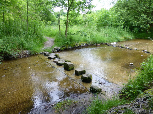
Stepping stones cross a feeder channel for Arnfield Reservoir
Weather for this location
Next 14 daysNearby places
Useful places within 5 km
Own or manage this place?
Claim this listing to keep details accurate, add photos, and highlight what makes it special — free.
Claim this page→How useful was the information on this page?
id: 2347add4-e352-49c6-a020-8c00e7cb302c
Wildlife to spot
15,124 records · National Biodiversity Network
Wildlife to spot
15,124 records · National Biodiversity Network🐦Birds56 species
autumnwinter
2026▾
Magpie · Robin · Blue Tit · Woodpigeon · Nuthatch +51
- MagpiePica pica2025
- RobinErithacus rubecula2025
- Blue TitCyanistes caeruleus2025
- WoodpigeonColumba palumbus2025
- NuthatchSitta europaea2025
- Canada GooseBranta canadensis2025
- ChaffinchFringilla coelebs2025
- Carrion CrowCorvus corone2025
- MallardAnas platyrhynchos2025
- Black-headed GullChroicocephalus ridibundus2025
- PheasantPhasianus colchicus2025
- FieldfareTurdus pilaris2025
- JackdawColoeus monedula2025
- BlackbirdTurdus merula2025
- Great TitParus major2025
- GoldfinchCarduelis carduelis2025
- RookCorvus frugilegus2025
- Coal TitPeriparus ater2025
- WrenTroglodytes troglodytes2025
- KestrelFalco tinnunculus2025
- BullfinchPyrrhula pyrrhula2025
- RedwingTurdus iliacus
- Song ThrushTurdus philomelos2025
- DunnockPrunella modularis2025
- Green WoodpeckerPicus viridis2025
- GoldcrestRegulus regulus2025
- Stock DoveColumba oenas2025
- JayGarrulus glandarius2025
- Long-tailed TitAegithalos caudatus2025
- TreecreeperCerthia familiaris2025
- LapwingVanellus vanellus
- StonechatSaxicola rubicola2025
- House SparrowPasser domesticus2025
- StarlingSturnus vulgaris2025
- SiskinSpinus spinus2025
- MoorhenGallinula chloropus2025
- Pink-footed GooseAnser brachyrhynchus2025
- Meadow PipitAnthus pratensis2025
- Collared DoveStreptopelia decaocto2025
- Pied WagtailMotacilla alba yarrellii2025
- GreenfinchChloris chloris2025
- TealAnas crecca2025
- Mute SwanCygnus olor2025
- SwallowHirundo rustica
- KittiwakeRissa tridactyla
- OystercatcherHaematopus ostralegus
- Common GullLarus canus2025
- Herring GullLarus argentatus2025
- Mistle ThrushTurdus viscivorus2025
- CormorantPhalacrocorax carbo2025
- WoodcockScolopax rusticola2025
- SnipeGallinago gallinago2025
- Lesser Black-backed GullLarus fuscus2025
- Reed BuntingEmberiza schoeniclus2025
- Great Spotted WoodpeckerDendrocopos major2025
- Little OwlAthene noctua2025
🦌Mammals4 species
winterspringautumn
2026▾
Roe Deer · Stoat · Wood Mouse · Grey Squirrel
- Roe DeerCapreolus capreolus
- StoatMustela erminea
- Wood MouseApodemus sylvaticus
- Grey SquirrelSciurus carolinensis2025
🐸Amphibians1 species
winter
2026▾
Common Frog
- Common FrogRana temporaria
🐝Insects7 species
winterspring
2026▾
Hawthorn Shieldbug · Scoliocentra villosa · Philopotamus montanus · Hairy Shieldbug · 7-spot Ladybird +2
- Hawthorn ShieldbugAcanthosoma haemorrhoidale
- Scoliocentra villosaScoliocentra villosa
- Philopotamus montanusPhilopotamus montanus
- Hairy ShieldbugDolycoris baccarum
- 7-spot LadybirdCoccinella septempunctata
- Odontocerum albicorneOdontocerum albicorne
Wall-rue · Maidenhair Spleenwort
- Wall-rueAsplenium ruta-muraria
- Maidenhair SpleenwortAsplenium trichomanes
Species observations from the last 10 years via NBN Atlas
Events & activities nearby
Switch provider to compare local events, tours and bookable activities.