🦉 Wildlife🦅 Birds🦋 Insects
↑ Share
Public access Free entry Dogs welcome 2 ha
Places › England › South East › Canterbury Getting here
51.34407, 1.11934
Open directionsv Visiting this summer
Seasonal nature notes and what to look for now
▾ 🌞 Midsummer — early morning visits most comfortable; look for deer fawns in quieter clearings 🐕 Early mornings are best for dog walks in summer — visit before 9am to avoid the heat and find quieter trails 🛝 Playground 125m away — built-in entertainment for younger visitors alongside the wider site 🌤️ Visiting this summer
🌞 Midsummer — early morning visits most comfortable; look for deer fawns in quieter clearings 🐕 Early mornings are best for dog walks in summer — visit before 9am to avoid the heat and find quieter trails 🛝 Playground 125m away — built-in entertainment for younger visitors alongside the wider site £ Free to visit — no entry charge🐕 Dogs welcome🦉 Wildlife
Very strong match
Multi-group wildlife — Amphibians, Birds, Mammals, Reptiles; Multi-group wildlife — Amphibians, Birds, Mammals, Reptiles
Free
🦅 Bird watching
Very strong match
Birds — Robin, Blue Tit, Great Tit +52 more · last seen 2026; Birds — Robin, Blue Tit, Great Tit +52 more · last seen 2026
Free
🦋 Insect spotting
Strong match
Insects — Meadow Brown, Gatekeeper, Red-legged Shieldbug +85 more · last seen 2026; Insects — Meadow Brown, Gatekeeper, Red-legged Shieldbug +85 more · last seen 2026
Free
Dogs allowed — public woodland
Free
🛝 Family friendly
Good match
playground
Free
Trails nearby Within roughly 5 km 7 signed routes nearby · 6 public paths nearby
Signed route nearby Public paths
Stour Valley Walk Walking route ▾
Named route Listed length 82.9 km Regional walking route
Show on map Saxon Shore Way Walking route 262 km ▾
Named route Length 262 km Regional walking route
Show on map Augustine Camino Walking route ▾
Named route Regional walking route
Show on map King Charles III England Coast Path: Ramsgate to Whitstable Walking route ▾
Named route Ref ECP National walking route
Show on map Wantsum Walk Walking route ▾
Named route Local walking route
Show on map 48 signed routes nearby
Signed route nearby
NCN Regional Route 15 (Kent) Cycling route ▾
Named route Ref 15 Regional cycle route
Show on map NCN National Route 1 Dover to Canterbury Cycling route ▾
Named route Ref 1 National Cycle Network
Show on map Crab & Winkle Link Cycling route ▾
Named route Ref 1 National Cycle Network
Show on map Crab & Winkle Way Cycling route ▾
Named route Ref 1 National Cycle Network
Show on map N/A Cycling route 19 m ▾
Named route Ref 15 Length 19 m National Cycle Network Traffic-free Surface asphalt
Show on map Alternative Route Cycling route 924 m ▾
Named route Ref 1 Length 924 m National Cycle Network On-road Surface asphalt
Show on map 7 public paths nearby
Public paths
Swallow Court bridleway · 16 m ▾
Public path bridleway Length 16 m Surface asphalt Path type: cycleway
Show on map Swallow Court bridleway · 29 m ▾
Public path bridleway Length 29 m Path type: residential
Show on map Swallow Court bridleway · 40 m ▾
Public path bridleway Length 40 m Path type: residential
Show on map Falcon Close bridleway · 87 m ▾
Public path bridleway Length 87 m Path type: residential
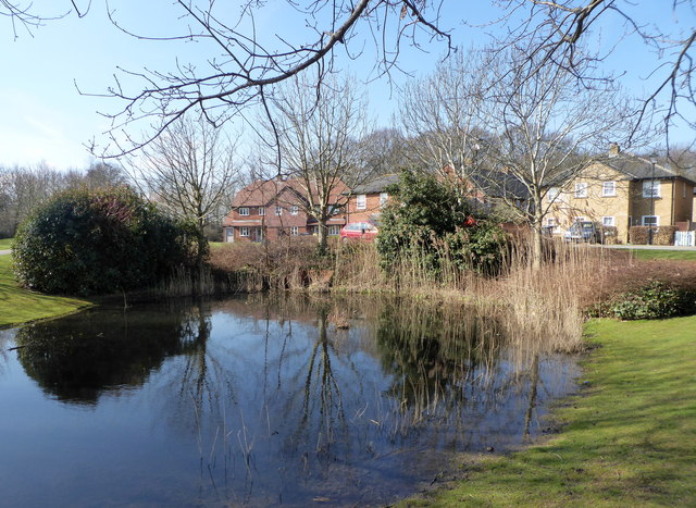
Show on map Photos Pond by the A291 (Canterbury Road), Herne
‹ ›
Weather for this location Next 14 days Nearby places Useful places within 5 km
All Historic
Own or manage this place?
Claim this listing to keep details accurate, add photos, and highlight what makes it special — free.
Claim this page→ How useful was the information on this page?
Something wrong on this page?
id: e594f02f-a45d-459f-81ab-3e5b3323a8c4
UK green spaces mapped from open public data — so anyone can find the woodland, trail, or nature reserve closest to them.
© 2026 Glade · Made with care for UK green spaces
Wildlife to spot
24,761 records · National Biodiversity Network
▾
Wildlife to spot 24,761 records · National Biodiversity Network 🐦 Birds 31 species
winter summer
2026 ▾
Great Spotted Woodpecker · Robin · Great Tit · Blue Tit · Wren +26
Great Spotted Woodpecker Dendrocopos major Robin Erithacus rubecula Great Tit Parus major Blue Tit Cyanistes caeruleus Wren Troglodytes troglodytes Green Woodpecker Picus viridis Long-tailed Tit Aegithalos caudatus Blackbird Turdus merula Chaffinch Fringilla coelebs Woodpigeon Columba palumbus Jackdaw Coloeus monedula Jay Garrulus glandarius Magpie Pica pica Dunnock Prunella modularis Goldfinch Carduelis carduelis Lesser Spotted Woodpecker Dryobates minor2025 Nuthatch Sitta europaea2025 Treecreeper Certhia familiaris House Sparrow Passer domesticus Collared Dove Streptopelia decaocto Starling Sturnus vulgaris Coal Tit Periparus ater Goldcrest Regulus regulus2025 Swallow Hirundo rustica2025 Black-headed Gull Chroicocephalus ridibundus Redwing Turdus iliacus2025 Moorhen Gallinula chloropus2025 Carrion Crow Corvus corone2025 Stock Dove Columba oenas2025 Chiffchaff Phylloscopus collybita2025 Herring Gull Larus argentatus2025 🦌 Mammals 9 species
winter autumn
2026 ▾
Red Fox · Bank Vole · Brown Rat · Grey Squirrel · Hedgehog +4
Red Fox Vulpes vulpes Bank Vole Myodes glareolus Brown Rat Rattus norvegicus Grey Squirrel Sciurus carolinensis Hedgehog Erinaceus europaeus2025 Mole Talpa europaea2025 Common Lizard · Slow-worm
Common Lizard Zootoca vivipara Slow-worm Anguis fragilis 🐸 Amphibians 1 species
winter spring
2026 ▾
Palmate Newt
Palmate Newt Lissotriton helveticus 🐝 Insects 22 species
spring summer autumn
2026 ▾
Red-legged Shieldbug · 7-spot Ladybird · Firebug · Common Darter · Green Shieldbug +17
Red-legged Shieldbug Pentatoma rufipes2025 7-spot Ladybird Coccinella septempunctata Firebug Pyrrhocoris apterus Common Darter Sympetrum striolatum2025 Green Shieldbug Palomena prasina Species observations from the last 10 years via NBN Atlas
Wood Mouse Apodemus sylvaticus2025
Wood Mouse Apodemus sylvaticus2025
Pygmy Shrew Sorex minutus2025
Pygmy Shrew Sorex minutus2025
Yellow-necked Mouse Apodemus flavicollis2025
Yellow-necked Mouse Apodemus flavicollis2025 Nalassus laevioctostriatus
Nalassus laevioctostriatus
Nalassus laevioctostriatus
Nalassus laevioctostriatus
Dark-edged Bee-fly Bombylius major
Dark-edged Bee-fly Bombylius major
Minotaur Beetle Typhaeus typhoeus
Minotaur Beetle Typhaeus typhoeus
Syrphus torvus Syrphus torvus
Syrphus torvus Syrphus torvus
Harlequin Ladybird Harmonia axyridis
Harlequin Ladybird Harmonia axyridis
Eristalis tenax Eristalis tenax
Eristalis tenax Eristalis tenax
Scathophaga stercoraria Scathophaga stercoraria
Scathophaga stercoraria Scathophaga stercoraria
Dock Bug Coreus marginatus
Dock Bug Coreus marginatus
Epistrophe eligans Epistrophe eligans
Epistrophe eligans Epistrophe eligans
Eupeodes luniger Eupeodes luniger2025
Eupeodes luniger Eupeodes luniger2025
Hairy Shieldbug Dolycoris baccarum2025
Hairy Shieldbug Dolycoris baccarum2025
Willow Emerald Damselfly Chalcolestes viridis2025
Willow Emerald Damselfly Chalcolestes viridis2025
Twin-spot Centurion Sargus bipunctatus2025
Twin-spot Centurion Sargus bipunctatus2025
Myrmus miriformis Myrmus miriformis2025
Myrmus miriformis Myrmus miriformis2025
Southern Oak Bush-cricket Meconema meridionale2025
Southern Oak Bush-cricket Meconema meridionale2025
Ruddy Darter Sympetrum sanguineum2025
Ruddy Darter Sympetrum sanguineum2025
Migrant Hawker Aeshna mixta2025
Migrant Hawker Aeshna mixta2025 Events & activities nearby Switch provider to compare local events, tours and bookable activities.
Bookable tours GetYourGuide Promote here