🌞Midsummer — early morning visits most comfortable; look for deer fawns in quieter clearings
🐕Early mornings are best for dog walks in summer — visit before 9am to avoid the heat and find quieter trails
📍Open access throughout summer — no booking required
🌤️ Visiting this summer
🌞Midsummer — early morning visits most comfortable; look for deer fawns in quieter clearings
🐕Early mornings are best for dog walks in summer — visit before 9am to avoid the heat and find quieter trails
📍Open access throughout summer — no booking required
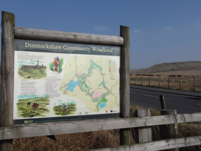
Good to know
£Free to visit — no entry charge
🐕Dogs welcome
🐴Horse riding
Best for
7 activities
🐶
Dog walks
Strong match
Dogs allowed — public woodland
Free
🐴
Horse riding
Strong match
Horse riding listed as facility
Varies
🦅
Bird watching
Good match
Moorland — golden plover, curlew and short-eared owl
Free
🦉
Wildlife
Good match
Grass moorland priority habitat
Free
🌲
Forest walks
Good match
Public woodland
Free
🥾
Hiking
Good match
Named hiking route nearby: Mary Towneley Loop
Free
Trails nearby
Within roughly 5 km
🚶
Walking
▾
5 signed routes nearby · 1 public path nearby
Signed route nearbyPublic paths
Mary Towneley LoopWalking route▾
Forms part of Pennine Bridleway National Trail
Named routeRegional walking route
Irwell Sculpture TrailWalking route▾
Named routeRegional walking route
Rossendale WayWalking route▾
A high-level route around Bacup, Rawtenstall, Haslingden and Whitworth in the Rossendale Valley, crossing the open moors and farmland of the South Pennines which roughly follows the Rossendale Borough boundary.
Named routeRegional walking route
Todmorden Centenary WayWalking route▾
Named routeLocal walking route
Burnley WayWalking route▾
Named routeRef BuWRegional walking route
🚴
Cycling
▾
11 signed routes nearby
Signed route nearby
Pennine CyclewayCycling route▾
Named routeRef 68National Cycle Network
Lancashire Cycleway (Southern Loop)Cycling route▾
Named routeRef 91Regional cycle route
Route 604Cycling route▾
Named routeRef 604National Cycle Network
Britannia GreenwayCycling route▾
Named routeLocal cycle route
Route 685Cycling route▾
Named routeRef 685National Cycle Network
Main RouteCycling route799 m▾
Named routeRef 685Length 799 mNational Cycle NetworkTraffic-freeSurface asphalt
🐴
Horse riding
▾
5 public paths nearby
Public paths
Mary Towneley Loopbridleway · 777 m▾
Public pathbridlewayLength 777 mPath type: bridleway
Mary Towneley Loopbridleway · 3 m▾
Public pathbridlewayLength 3 mPath type: bridleway
Mary Townley Loop / Peninne Bridlewaybridleway · 491 m▾
Public pathbridlewayLength 491 mSurface dirtPath type: bridleway
Mary Towneley Loopbridleway · 385 m▾
Public pathbridlewayLength 385 mPath type: bridleway
Mary Townley Loop / Peninne Bridlewaybridleway · 514 m▾
Public pathbridlewayLength 514 mSurface dirtPath type: bridleway