🌞Midsummer — early morning visits most comfortable; look for deer fawns in quieter clearings
🐕Early mornings are best for dog walks in summer — visit before 9am to avoid the heat and find quieter trails
🅿️Parking 269m away — 8 car parks within reach
🌤️ Visiting this summer
🌞Midsummer — early morning visits most comfortable; look for deer fawns in quieter clearings
🐕Early mornings are best for dog walks in summer — visit before 9am to avoid the heat and find quieter trails
🅿️Parking 269m away — 8 car parks within reach
Good to know
£Free to visit — no entry charge
🐕Dogs welcome
🅿️Parking· Free
Best for
6 activities
🦅
Bird watching
Strong match
Nature reserve
Free
🦉
Wildlife
Strong match
Nature reserve
Free
🐶
Dog walks
Strong match
Dogs allowed — nature reserve
Free
🌲
Forest walks
Strong match
Nature reserve
Free
🍂
Seasonal nature
Good match
Nature reserve — seasonal wildlife and habitats
Free
🧺
Picnic day out
Moderate match
Nature reserve — public outdoor space
Free
Trails nearby
Within roughly 5 km
🚶
Walking
▾
37 signed routes nearby · 13 public paths nearby
Signed route nearbyPublic paths
Monarch's WayWalking route990 km▾
approximate route of Charles II's escape
Named routeRef MWLength 990 kmRegional walking route
Dudley Geological Heritage TrailWalking route▾
Discover millions of years of geological history along this heritage trail. This tour allows you to experience
Dudley’s fascinating history through its buildings.
Named routeLocal walking route
Down The Bumble Hole- Windmill End TrailWalking route3 km▾
Short trail exploring Windmill End- a tranquil Black Country spot. Today, featuring birdsong, cyclists and water voles. Yet in the 1700/1800s it was a noisy, dirty workshop lined with factories, boatyards, blast furnaces and collieries.
Named routeRef WETLength 3 kmPoint-to-pointLocal walking route
Alder Coppice: Yellow PathWalking route▾
The shortest of three trails created alongside the designation of Alder Coppice into a Nature Reserve
Named routeRef AC-YLocal walking route
Doulton Trail (Saltwells LNR)Walking route1.5 km▾
Walking trail around a bluebell-covered Ancient Woodland and nationally important heritage urban nature reserve. Includes one long and steep flight of stairs but generally good surfaced paths and gentle gradients.
Named routeLength 1.5 kmRound tripLocal walking route
Named routeRef Starley NetworkLength 804 kmRegional cycle route
National Cycle Network 54 (removed)Cycling route▾
Named routeRef 54Local cycle route
Dudley Port CircularCycling route14 km▾
Follow The Gower Branch, then turn right back onto The Old Main Line. For a more challenging route, continue along The New Main Line and cross at Bromford Junction. Take the ramp access to The Old Main Line and double back, crossing Blakeley Hall Bridge.
Named routeLength 14 kmRound tripLocal cycle route
🐴
Horse riding
▾
1 public path nearby
Public paths
No named routes yet. Public paths are shown on the map.
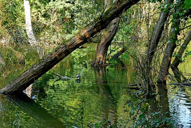
About this nature reserve
Cotwall End is a 56-hectare Local Nature Reserve situated in Dudley, West Midlands. It features ancient woodlands and meadows, where wildlife enthusiasts can find diverse plant life and observe various bird species and small mammals.