Plan your visit
🦉 Wildlife🌿 Foraging🦅 Birds
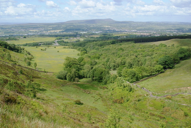
Public access Free entry Dogs welcome 12 ha
Places › England › North West › Burnley Getting here
53.76431, -2.32757
Open directionsv Visiting this summer
Seasonal nature notes and what to look for now
▾ 🌞 Midsummer — early morning visits most comfortable; look for deer fawns in quieter clearings 🌿 Foraging is at its best in summer here 🐕 Dogs welcome — bring water in summer; the site has enough space to find shade on hot days 🌤️ Visiting this summer
🌞 Midsummer — early morning visits most comfortable; look for deer fawns in quieter clearings 🌿 Foraging is at its best in summer here 🐕 Dogs welcome — bring water in summer; the site has enough space to find shade on hot days £ Free to visit — no entry charge🐕 Dogs welcome🦉 Wildlife
Very strong match
Multi-group wildlife — Amphibians, Birds, Mammals; Multi-group wildlife — Amphibians, Birds, Mammals
Free
Plants — Bilberry, Hawthorn, Common Nettle +17 more foraging species; Deciduous woodland — fungi, berries and wild garlic
Varies
🦅 Bird watching
Strong match
Birds — Woodpigeon, Carrion Crow, Magpie +36 more · last seen 2025; Birds — Woodpigeon, Carrion Crow, Magpie +36 more · last seen 2025
Free
🦋 Insect spotting
Strong match
Insects — Meadow Brown, Ringlet, Speckled Wood +159 more · last seen 2026; Insects — Meadow Brown, Ringlet, Speckled Wood +159 more · last seen 2026
Free
🍂 Seasonal nature
Strong match
Plants — Cleavers, Himalayan Balsam, Field Wood-rush +141 more · last seen 2025; Plants — Cleavers, Himalayan Balsam, Field Wood-rush +141 more · last seen 2025
Free
Dogs allowed — public woodland
Free
Trails nearby Within roughly 5 km 5 signed routes nearby · 48 public paths nearby
Signed route nearby Public paths
Rossendale Way Walking route ▾
A high-level route around Bacup, Rawtenstall, Haslingden and Whitworth in the Rossendale Valley, crossing the open moors and farmland of the South Pennines which roughly follows the Rossendale Borough boundary.
Named route Regional walking route
Show on map Bronte Way Walking route 71 km ▾
Named route Length 71 km Regional walking route
Show on map Burnley Way Walking route ▾
Named route Ref BuW Regional walking route
Show on map Great Harwood Nature Walk Walking route ▾
Named route Local walking route
Show on map Huncoat Trail Walking route ▾
Named route Local walking route
Show on map 67 signed routes nearby
Signed route nearby
Route 6 Cycling route ▾
Named route Ref 6 National Cycle Network
Show on map Route 604 Cycling route ▾
Named route Ref 604 National Cycle Network
Show on map Hyndburn Greenway Cycling route ▾
Named route Local cycle route
Show on map Huncoat Greenway Cycling route ▾
Named route Local cycle route
Show on map Route 685 Cycling route ▾
Named route Ref 685 National Cycle Network
Show on map Sweet Clough Greenway Cycling route ▾
Named route Local cycle route
Show on map 12 public paths nearby
Public paths
Kings Highway bridleway · 175 m ▾
Public path bridleway Length 175 m Path type: track
Show on map Kings Highway bridleway · 201 m ▾
Public path bridleway Length 201 m Path type: track
Show on map Kingsway bridleway · 11 m ▾
Public path bridleway Length 11 m Path type: residential
Show on map Kings Highway bridleway · 129 m ▾
Public path bridleway Length 129 m Path type: unclassified
Show on map Kings Highway bridleway · 319 m ▾
Public path bridleway Length 319 m Path type: unclassified
Show on map
Weather for this location Next 14 days Nearby places Useful places within 5 km
All Historic
Own or manage this place?
Claim this listing to keep details accurate, add photos, and highlight what makes it special — free.
Claim this page→ How useful was the information on this page?
id: acbebab4-220d-42a0-b0b0-0c1ba8f4daea
UK green spaces mapped from open public data — so anyone can find the woodland, trail, or nature reserve closest to them.
© 2026 Glade · Made with care for UK green spaces
Events & activities nearby Switch provider to compare local events, tours and bookable activities.
Bookable tours GetYourGuide Promote here
Wildlife to spot
4,312 records · National Biodiversity Network
▾
Wildlife to spot 4,312 records · National Biodiversity Network 🐦 Birds 6 species
summer autumn winter
2025 ▾
Carrion Crow · Woodpigeon · Magpie · Jay · Blackbird +1
Carrion Crow Corvus corone Woodpigeon Columba palumbus Magpie Pica pica Jay Garrulus glandarius Blackbird Turdus merula Jackdaw Coloeus monedula Hybos culiciformis · Melanostoma mellinum · Hilara chorica · Meadow Plant Bug · Pegoplata infirma +78
Hybos culiciformis Hybos culiciformis2025 Melanostoma mellinum Melanostoma mellinum2025 Hilara chorica Hilara chorica2025 Meadow Plant Bug Leptopterna dolabrata2025 Pegoplata infirma Pegoplata infirma2025 Western Honey Bee Common Vetch · Bilberry · Common Figwort · Meadow Buttercup · Silverweed +72
Common Vetch Vicia sativa Bilberry Vaccinium myrtillus Common Figwort Scrophularia nodosa Meadow Buttercup Ranunculus acris Silverweed Potentilla anserina Meadow Vetchling Lathyrus pratensis Bramble Rubus fruticosus Species observations from the last 10 years via NBN Atlas
Apis mellifera
Apis mellifera
Platycheirus granditarsus Platycheirus granditarsus2025
Platycheirus granditarsus Platycheirus granditarsus2025
Cuckoo-Spit Insect Philaenus spumarius2025
Cuckoo-Spit Insect Philaenus spumarius2025
Bicellaria vana Bicellaria vana2025
Bicellaria vana Bicellaria vana2025
Plagiognathus (Plagiognathus) arbustorum Plagiognathus (Plagiognathus) arbustorum2025
Plagiognathus (Plagiognathus) arbustorum Plagiognathus (Plagiognathus) arbustorum2025
Ocydromia glabricula Ocydromia glabricula2025
Ocydromia glabricula Ocydromia glabricula2025
Small Fleck-winged Snipefly Rhagio lineola2025
Small Fleck-winged Snipefly Rhagio lineola2025
Botanophila striolata Botanophila striolata2025
Botanophila striolata Botanophila striolata2025
Austrolimnophila ochracea Austrolimnophila ochracea2025
Austrolimnophila ochracea Austrolimnophila ochracea2025
Phaonia errans Phaonia errans2025
Phaonia errans Phaonia errans2025
Common Orange Legionnaire Beris vallata2025
Common Orange Legionnaire Beris vallata2025
Delia platura Delia platura2025
Delia platura Delia platura2025
Broad Centurion Chloromyia formosa2025
Broad Centurion Chloromyia formosa2025
Field Grasshopper Chorthippus brunneus2025
Field Grasshopper Chorthippus brunneus2025
Eristalis pertinax Eristalis pertinax2025
Eristalis pertinax Eristalis pertinax2025
Sallow Pea-galler Euura pedunculi2025
Sallow Pea-galler Euura pedunculi2025
Cicadella viridis Cicadella viridis2025
Cicadella viridis Cicadella viridis2025
Common Green Grasshopper Omocestus viridulus2025
Common Green Grasshopper Omocestus viridulus2025
Dasysyrphus albostriatus Dasysyrphus albostriatus2025
Dasysyrphus albostriatus Dasysyrphus albostriatus2025
7-spot Ladybird Coccinella septempunctata2025
7-spot Ladybird Coccinella septempunctata2025
Green Shieldbug Palomena prasina2025
Green Shieldbug Palomena prasina2025
White-tailed Bumblebee Bombus lucorum/terrestris/magnus/cryptarum2025
White-tailed Bumblebee Bombus lucorum/terrestris/magnus/cryptarum2025
Sitona Sitona2025
Sitona Sitona2025
Common Carder Bee Bombus pascuorum2025
Common Carder Bee Bombus pascuorum2025
Graphomya maculata Graphomya maculata2025
Graphomya maculata Graphomya maculata2025
Brown Hawker Aeshna grandis2025
Brown Hawker Aeshna grandis2025
Eristalis tenax Eristalis tenax2025
Eristalis tenax Eristalis tenax2025
Common Flower Bug Anthocoris nemorum2025
Common Flower Bug Anthocoris nemorum2025
Marmalade Hoverfly Episyrphus balteatus2025
Marmalade Hoverfly Episyrphus balteatus2025
Helophilus pendulus Helophilus pendulus2025
Helophilus pendulus Helophilus pendulus2025
Mecomma (Mecomma) ambulans Mecomma (Mecomma) ambulans2025
Mecomma (Mecomma) ambulans Mecomma (Mecomma) ambulans2025
Empis aestiva Empis aestiva2025
Empis aestiva Empis aestiva2025
Fannia fuscula Fannia fuscula2025
Fannia fuscula Fannia fuscula2025
Hilara litorea Hilara litorea2025
Hilara litorea Hilara litorea2025
Opomyza petrei Opomyza petrei2025
Opomyza petrei Opomyza petrei2025
Coenosia infantula Coenosia infantula2025
Coenosia infantula Coenosia infantula2025
Tipula lateralis Tipula lateralis2025
Tipula lateralis Tipula lateralis2025
Coenosia pedella Coenosia pedella2025
Coenosia pedella Coenosia pedella2025
Scathophaga stercoraria Scathophaga stercoraria2025
Scathophaga stercoraria Scathophaga stercoraria2025
Red-legged Shieldbug Pentatoma rufipes2025
Red-legged Shieldbug Pentatoma rufipes2025
Muscina prolapsa Muscina prolapsa2025
Muscina prolapsa Muscina prolapsa2025
Verrallia aucta Verrallia aucta2025
Verrallia aucta Verrallia aucta2025
Stenodema (Stenodema) laevigata Stenodema (Stenodema) laevigata2025
Stenodema (Stenodema) laevigata Stenodema (Stenodema) laevigata2025
Meiosimyza subfasciata Meiosimyza subfasciata2025
Meiosimyza subfasciata Meiosimyza subfasciata2025
Molophilus appendiculatus Molophilus appendiculatus2025
Molophilus appendiculatus Molophilus appendiculatus2025
Spilogona contractifrons Spilogona contractifrons2025
Spilogona contractifrons Spilogona contractifrons2025
Sapromyza hyalinata Sapromyza hyalinata2025
Sapromyza hyalinata Sapromyza hyalinata2025
Timothy Grassbug Stenotus binotatus2025
Timothy Grassbug Stenotus binotatus2025
Empis nuntia Empis nuntia2025
Empis nuntia Empis nuntia2025
Hilara cornicula Hilara cornicula2025
Hilara cornicula Hilara cornicula2025
Dull Four-spined Legionnaire Chorisops tibialis2025
Dull Four-spined Legionnaire Chorisops tibialis2025
Anthomyia liturata Anthomyia liturata2025
Anthomyia liturata Anthomyia liturata2025
Opomyza germinationis Opomyza germinationis2025
Opomyza germinationis Opomyza germinationis2025
Black Snipefly Chrysopilus cristatus2025
Black Snipefly Chrysopilus cristatus2025
Oncopsis flavicollis Oncopsis flavicollis2025
Oncopsis flavicollis Oncopsis flavicollis2025
Limnophora riparia Limnophora riparia2025
Limnophora riparia Limnophora riparia2025
Eupeodes latifasciatus Eupeodes latifasciatus2025
Eupeodes latifasciatus Eupeodes latifasciatus2025
Baccha elongata Baccha elongata2025
Baccha elongata Baccha elongata2025
Eupeodes luniger Eupeodes luniger2025
Eupeodes luniger Eupeodes luniger2025
Birch Catkin Bug Kleidocerys resedae2025
Birch Catkin Bug Kleidocerys resedae2025
Fannia postica Fannia postica2025
Fannia postica Fannia postica2025
Pseudocoenosia solitaria Pseudocoenosia solitaria2025
Pseudocoenosia solitaria Pseudocoenosia solitaria2025
Phaonia halterata Phaonia halterata2025
Phaonia halterata Phaonia halterata2025
Botanophila fugax Botanophila fugax2025
Botanophila fugax Botanophila fugax2025
Eudasyphora cyanella Eudasyphora cyanella2025
Eudasyphora cyanella Eudasyphora cyanella2025
Hilara quadrifasciata Hilara quadrifasciata2025
Hilara quadrifasciata Hilara quadrifasciata2025
Small Heather Weevil Micrelus ericae2025
Small Heather Weevil Micrelus ericae2025
Platypalpus candicans Platypalpus candicans2025
Platypalpus candicans Platypalpus candicans2025
Platypalpus pectoralis Platypalpus pectoralis2025
Platypalpus pectoralis Platypalpus pectoralis2025
Ormosia nodulosa Ormosia nodulosa2025
Ormosia nodulosa Ormosia nodulosa2025
Dicranophragma nemorale Dicranophragma nemorale2025
Dicranophragma nemorale Dicranophragma nemorale2025
Fannia polychaeta Fannia polychaeta2025
Fannia polychaeta Fannia polychaeta2025
Empis livida Empis livida2025
Empis livida Empis livida2025
Platycheirus albimanus Platycheirus albimanus2025
Platycheirus albimanus Platycheirus albimanus2025
Potato Capsid Closterotomus norwegicus2025
Potato Capsid Closterotomus norwegicus2025
Coenosia intermedia Coenosia intermedia2025
Coenosia intermedia Coenosia intermedia2025
Plagiognathus (Plagiognathus) chrysanthemi Plagiognathus (Plagiognathus) chrysanthemi2025
Plagiognathus (Plagiognathus) chrysanthemi Plagiognathus (Plagiognathus) chrysanthemi2025
Cixius nervosus Cixius nervosus2025
Cixius nervosus Cixius nervosus2025
Scentless Mayweed Tripleurospermum inodorum
Scentless Mayweed Tripleurospermum inodorum
Pineappleweed Matricaria discoidea
Pineappleweed Matricaria discoidea
Redshank Persicaria maculosa
Redshank Persicaria maculosa
Hedge Bindweed Calystegia sepium
Hedge Bindweed Calystegia sepium
Great Willowherb Epilobium hirsutum
Great Willowherb Epilobium hirsutum
Sneezewort Achillea ptarmica
Sneezewort Achillea ptarmica
Greater Bird's-foot-trefoil Lotus pedunculatus
Greater Bird's-foot-trefoil Lotus pedunculatus
Water Figwort Scrophularia auriculata
Water Figwort Scrophularia auriculata
Smooth Hawk's-beard Crepis capillaris
Smooth Hawk's-beard Crepis capillaris
Wild Carrot Daucus carota
Wild Carrot Daucus carota
Branched Bur-reed Sparganium erectum
Branched Bur-reed Sparganium erectum
Lesser Trefoil Trifolium dubium
Lesser Trefoil Trifolium dubium
Broad-leaved Willowherb Epilobium montanum
Broad-leaved Willowherb Epilobium montanum
Common Centaury Centaurium erythraea
Common Centaury Centaurium erythraea
Japanese Knotweed Reynoutria japonica
Japanese Knotweed Reynoutria japonica
Herb-Robert Geranium robertianum
Herb-Robert Geranium robertianum
Greater Plantain Plantago major
Greater Plantain Plantago major
Zigzag Clover Trifolium medium
Zigzag Clover Trifolium medium
Hop Trefoil Trifolium campestre
Hop Trefoil Trifolium campestre
Red Bartsia Odontites vernus
Red Bartsia Odontites vernus
Perforate St John's-wort Hypericum perforatum
Perforate St John's-wort Hypericum perforatum
Fairy Flax Linum catharticum
Fairy Flax Linum catharticum
Hard Rush Juncus inflexus
Hard Rush Juncus inflexus
Eyebright Euphrasia
Eyebright Euphrasia
White Clover Trifolium repens
White Clover Trifolium repens
Yellow Iris Iris pseudacorus
Yellow Iris Iris pseudacorus
Himalayan Balsam Impatiens glandulifera
Himalayan Balsam Impatiens glandulifera
Tall Melilot Melilotus altissimus
Tall Melilot Melilotus altissimus
Purple-loosestrife Lythrum salicaria
Purple-loosestrife Lythrum salicaria
Alder Alnus glutinosa
Alder Alnus glutinosa
Hazel Corylus avellana
Hazel Corylus avellana
Ash Fraxinus excelsior
Ash Fraxinus excelsior
Red Clover Trifolium pratense
Red Clover Trifolium pratense
Pedunculate Oak Quercus robur
Pedunculate Oak Quercus robur
Dotted Loosestrife Lysimachia punctata
Dotted Loosestrife Lysimachia punctata
Prickly Sow-thistle Sonchus asper
Prickly Sow-thistle Sonchus asper
Selfheal Prunella vulgaris
Selfheal Prunella vulgaris
Sticky Groundsel Senecio viscosus
Sticky Groundsel Senecio viscosus
Black Medick Medicago lupulina
Black Medick Medicago lupulina
Marsh Woundwort Stachys palustris
Marsh Woundwort Stachys palustris
Water Mint Mentha aquatica
Water Mint Mentha aquatica
Ribwort Plantain Plantago lanceolata
Ribwort Plantain Plantago lanceolata
Creeping Cinquefoil Potentilla reptans
Creeping Cinquefoil Potentilla reptans
Creeping Thistle Cirsium arvense
Creeping Thistle Cirsium arvense
Wild Marjoram Origanum vulgare
Wild Marjoram Origanum vulgare
Common Bird's-foot-trefoil Lotus corniculatus
Common Bird's-foot-trefoil Lotus corniculatus
Perennial Sow-thistle Sonchus arvensis
Perennial Sow-thistle Sonchus arvensis
Tufted Vetch Vicia cracca
Tufted Vetch Vicia cracca
Wild Teasel Dipsacus fullonum
Wild Teasel Dipsacus fullonum
Square-stalked St John's-wort Hypericum tetrapterum
Square-stalked St John's-wort Hypericum tetrapterum
Wild Angelica Angelica sylvestris
Wild Angelica Angelica sylvestris
Common Field-speedwell Veronica persica
Common Field-speedwell Veronica persica
Oxeye Daisy Leucanthemum vulgare
Oxeye Daisy Leucanthemum vulgare
Pendulous Sedge Carex pendula
Pendulous Sedge Carex pendula
Common Nettle Urtica dioica
Common Nettle Urtica dioica
Common Ragwort Jacobaea vulgaris
Common Ragwort Jacobaea vulgaris
Ivy Hedera helix
Ivy Hedera helix
Guelder-rose Viburnum opulus
Guelder-rose Viburnum opulus
Curled Dock Rumex crispus
Curled Dock Rumex crispus
Hoary Willowherb Epilobium parviflorum
Hoary Willowherb Epilobium parviflorum
Bush Vetch Vicia sepium
Bush Vetch Vicia sepium
Rosebay Willowherb Chamaenerion angustifolium
Rosebay Willowherb Chamaenerion angustifolium
Wintergreen Pyrola rotundifolia
Wintergreen Pyrola rotundifolia
American Willowherb Epilobium ciliatum
American Willowherb Epilobium ciliatum
Silver Birch Betula pendula
Silver Birch Betula pendula
Garden Lady's-mantle Alchemilla mollis
Garden Lady's-mantle Alchemilla mollis
Creeping Buttercup Ranunculus repens
Creeping Buttercup Ranunculus repens
Common Knapweed Centaurea nigra subsp. nigra
Common Knapweed Centaurea nigra subsp. nigra
Dogwood Cornus sanguinea
Dogwood Cornus sanguinea
Hawthorn Crataegus monogyna
Hawthorn Crataegus monogyna