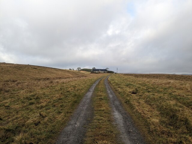
Foulshiels, Settlement 1 ha
🦉 Wildlife🦅 Birds🍄 Fungi
↑ Share
Dogs welcome 1 ha
Places › Scotland › South Scotland › Scottish Borders Getting here
55.21037, -2.79740
Open directionsv Visiting this summer
Seasonal nature notes and what to look for now
▾ 🌞 Midsummer — early morning visits most comfortable; look for deer fawns in quieter clearings 🍄 Mushroom foraging is at its best in summer here 🐕 Dogs welcome — bring water in summer; the site has enough space to find shade on hot days 🌤️ Visiting this summer
🌞 Midsummer — early morning visits most comfortable; look for deer fawns in quieter clearings 🍄 Mushroom foraging is at its best in summer here 🐕 Dogs welcome — bring water in summer; the site has enough space to find shade on hot days 🦉 Wildlife
Very strong match
Multi-group wildlife — Birds, Mammals, Reptiles; Multi-group wildlife — Birds, Mammals, Reptiles
Free
🦅 Bird watching
Very strong match
Birds — Fieldfare, Redwing, Chaffinch +61 more · last seen 2025; Birds — Fieldfare, Redwing, Chaffinch +61 more · last seen 2025
Free
🍄 Mushroom foraging
Strong match
Fungi — Oak Moss, Sprucecone Cap, Pine Powdercap +115 more · last seen 2019; Fungi — Oak Moss, Sprucecone Cap, Pine Powdercap +115 more · last seen 2019
Varies
🦋 Insect spotting
Strong match
Insects — Spruce Carpet, Hebrew Character, Nut-tree Tussock +158 more · last seen 2019; Insects — Spruce Carpet, Hebrew Character, Nut-tree Tussock +158 more · last seen 2019
Free
🍂 Seasonal nature
Strong match
Plants — Giant Hogweed, Japanese Knotweed, Melancholy Thistle +159 more · last seen 2022; Plants — Giant Hogweed, Japanese Knotweed, Melancholy Thistle +159 more · last seen 2022
Free
Trails nearby Within roughly 5 km 7 signed routes nearby
Signed route nearby
Reivers' Route Cycling route ▾
Named route Ref 10 National Cycle Network
Show on map National Byway (County Durham and Northumberland) Cycling route ▾
The National Byway route through County Durham and Northumberland
Named route Ref NB Regional cycle route
Show on map National Byway (SW Scotland) Cycling route ▾
National Byway in the Solway Firth area
Named route Ref NB Regional cycle route
Show on map Main Route Cycling route 504 m ▾
Named route Ref 10 Length 504 m National Cycle Network Traffic-free Surface unsealedfirm
Show on map Main Route Cycling route 2.1 km ▾
Named route Ref 10 Length 2.1 km National Cycle Network Traffic-free Surface unsealedfirm
Show on map Main Route Cycling route 86 m ▾
Named route Ref 10 Length 86 m National Cycle Network Traffic-free Surface unsealedfirm
Show on map 4 signed routes nearby
Signed route nearby
The Red Route Mountain bike route ▾
The Blue Route Mountain bike route ▾
Cross Border MTB Trail Mountain bike route ▾
Great North Trail (Scottish Borders) Mountain bike route 154.8 km ▾
Named route Length 154.8 km National Cycle Network
Show on map
Weather for this location Next 14 days Nearby places Useful places within 5 km
All Historic
Own or manage this place?
Claim this listing to keep details accurate, add photos, and highlight what makes it special — free.
Claim this page→ How useful was the information on this page?
Something wrong on this page?
id: 2e6473d3-480b-473b-9917-d23633d7ce79
UK green spaces mapped from open public data — so anyone can find the woodland, trail, or nature reserve closest to them.
© 2026 Glade · Made with care for UK green spaces
Wildlife to spot
1,861 records · National Biodiversity Network
▾
Wildlife to spot 1,861 records · National Biodiversity Network 🐦 Birds 41 species
winter spring summer autumn
2025 ▾
Fieldfare · Redwing · Buzzard · Brambling · Chaffinch +36
Fieldfare Turdus pilaris Redwing Turdus iliacus Buzzard Buteo buteo Brambling Fringilla montifringilla Chaffinch Fringilla coelebs Tawny Owl Strix aluco2023 Oystercatcher Haematopus ostralegus Chiffchaff Phylloscopus collybita Common Sandpiper Actitis hypoleucos2022 Blackcap Sylvia atricapilla Sand Martin Riparia riparia Wren Troglodytes troglodytes Grey Wagtail Motacilla cinerea Willow Warbler Phylloscopus trochilus Nuthatch Sitta europaea Swallow Hirundo rustica2024 Stock Dove Columba oenas2023 Cuckoo Cuculus canorus2023 Magpie Pica pica2023 House Sparrow Passer domesticus2020 Woodcock Scolopax rusticola2018 Great Spotted Woodpecker Dendrocopos major2017 Spotted Flycatcher Muscicapa striata Robin Erithacus rubecula Goldfinch Carduelis carduelis Skylark Alauda arvensis Blackbird Turdus merula Wheatear Oenanthe oenanthe2023 Linnet Linaria cannabina2023 Mistle Thrush Turdus viscivorus2023 Meadow Pipit Anthus pratensis2022 Swift Apus apus2022 Tyto alba alba Tyto alba alba2019 Snipe Gallinago gallinago2019 Lapwing Vanellus vanellus2019 Short-eared Owl Asio flammeus2019 Goldcrest Regulus regulus2018 Hawfinch Coccothraustes coccothraustes2017 Curlew Numenius arquata2017 Grey Heron Ardea cinerea2017 Sparrowhawk Accipiter nisus2017 🦌 Mammals 3 species
spring summer autumn
2025 ▾
Grey Squirrel · Red Squirrel · Roe Deer
Grey Squirrel Sciurus carolinensis2024 Red Squirrel Sciurus vulgaris2021 Roe Deer Capreolus capreolus Common Lizard
Common Lizard Zootoca vivipara Spruce Carpet · Clouded Drab · Hebrew Character · Rosy Rustic · Canary-shouldered Thorn +149
Spruce Carpet Thera britannica Clouded Drab Orthosia incerta Hebrew Character Orthosia gothica Rosy Rustic Hydraecia micacea Canary-shouldered Thorn Ennomos alniaria Brimstone Moth Opisthograptis luteolata Large Yellow Underwing Sprucecone Cap · Milking Bonnet · Blistered Woodwax · Pine Powdercap · Snakeskin Brownie +36
Sprucecone Cap Strobilurus esculentus Milking Bonnet Mycena galopus var. galopus Blistered Woodwax Hygrophorus pustulatus Pine Powdercap Cystoderma jasonis Snakeskin Brownie Hypholoma marginatum Violet Bramble Rust Phragmidium violaceum Spotted Toughshank Giant Hogweed · Japanese Knotweed · Goldilocks Buttercup · Bush Vetch · Polypodium vulgare +193
Giant Hogweed Heracleum mantegazzianum2022 Japanese Knotweed Reynoutria japonica2022 Goldilocks Buttercup Ranunculus auricomus2019 Bush Vetch Vicia sepium2019 Polypodium vulgare Polypodium vulgare2019 Pignut Species observations from the last 10 years via NBN Atlas
Noctua pronuba
Noctua pronuba
Nut-tree Tussock Colocasia coryli
Nut-tree Tussock Colocasia coryli
Four-dotted Footman Cybosia mesomella
Four-dotted Footman Cybosia mesomella
Beautiful Golden Y Autographa pulchrina
Beautiful Golden Y Autographa pulchrina
Elephant Hawk-moth Deilephila elpenor
Elephant Hawk-moth Deilephila elpenor
Buff Ermine Spilosoma lutea
Buff Ermine Spilosoma lutea
Burnished Brass Diachrysia chrysitis
Burnished Brass Diachrysia chrysitis
Flame Shoulder Ochropleura plecta
Flame Shoulder Ochropleura plecta
Clouded-bordered Brindle Apamea crenata
Clouded-bordered Brindle Apamea crenata
Small Square-spot Diarsia rubi
Small Square-spot Diarsia rubi
Broom Moth Ceramica pisi
Broom Moth Ceramica pisi
Red Chestnut Cerastis rubricosa
Red Chestnut Cerastis rubricosa
Powdered Quaker Orthosia gracilis
Powdered Quaker Orthosia gracilis
Common Quaker Orthosia cerasi
Common Quaker Orthosia cerasi
Pine Carpet Pennithera firmata
Pine Carpet Pennithera firmata
Peppered Moth Biston betularia
Peppered Moth Biston betularia
Buff-tip Phalera bucephala
Buff-tip Phalera bucephala
Dotted Clay Xestia baja
Dotted Clay Xestia baja
Drinker Euthrix potatoria
Drinker Euthrix potatoria
Poplar Hawk-moth Laothoe populi
Poplar Hawk-moth Laothoe populi
Common White Wave Cabera pusaria
Common White Wave Cabera pusaria
Snout Hypena proboscidalis
Snout Hypena proboscidalis
Purple Clay Diarsia brunnea
Purple Clay Diarsia brunnea
Common Marbled Carpet Dysstroma truncata
Common Marbled Carpet Dysstroma truncata
Twin-spotted Quaker Anorthoa munda
Twin-spotted Quaker Anorthoa munda
Silver Y Autographa gamma2018
Silver Y Autographa gamma2018
Flame Carpet Xanthorhoe designata2018
Flame Carpet Xanthorhoe designata2018
Centre-barred Sallow Atethmia centrago2018
Centre-barred Sallow Atethmia centrago2018
Autumnal Rustic Eugnorisma glareosa2018
Autumnal Rustic Eugnorisma glareosa2018
Common Carpet Epirrhoe alternata2017
Common Carpet Epirrhoe alternata2017
Smoky Wainscot Mythimna impura2017
Smoky Wainscot Mythimna impura2017
Lesser Swallow Prominent Pheosia gnoma2017
Lesser Swallow Prominent Pheosia gnoma2017
Pebble Prominent Notodonta ziczac2017
Pebble Prominent Notodonta ziczac2017
Sallow Cirrhia icteritia
Sallow Cirrhia icteritia
Frosted Orange Gortyna flavago
Frosted Orange Gortyna flavago
Yellow-Line Quaker Leptologia macilenta
Yellow-Line Quaker Leptologia macilenta
Straw Dot Rivula sericealis
Straw Dot Rivula sericealis
Green Carpet Colostygia pectinataria
Green Carpet Colostygia pectinataria
Scalloped Hook-tip Falcaria lacertinaria
Scalloped Hook-tip Falcaria lacertinaria
Small Dotted Buff Photedes minima
Small Dotted Buff Photedes minima
Iron Prominent Notodonta dromedarius
Iron Prominent Notodonta dromedarius
Dark Arches Apamea monoglypha
Dark Arches Apamea monoglypha
Flame Axylia putris
Flame Axylia putris
Campion Sideridis rivularis
Campion Sideridis rivularis
Garden Tiger Arctia caja
Garden Tiger Arctia caja
Barred Straw Gandaritis pyraliata
Barred Straw Gandaritis pyraliata
Purple Bar Cosmorhoe ocellata
Purple Bar Cosmorhoe ocellata
Small Rivulet Perizoma alchemillata
Small Rivulet Perizoma alchemillata
Double-square Spot Xestia triangulum
Double-square Spot Xestia triangulum
Antler Moth Cerapteryx graminis
Antler Moth Cerapteryx graminis
Dusky Brocade Apamea remissa
Dusky Brocade Apamea remissa
Pale-shouldered Brocade Lacanobia thalassina
Pale-shouldered Brocade Lacanobia thalassina
Red Sword-grass Xylena vetusta
Red Sword-grass Xylena vetusta
Small Quaker Orthosia cruda
Small Quaker Orthosia cruda
March Moth Alsophila aescularia
March Moth Alsophila aescularia
Small Wainscot Denticucullus pygmina2018
Small Wainscot Denticucullus pygmina2018
Dark Marbled Carpet Dysstroma citrata2018
Dark Marbled Carpet Dysstroma citrata2018
Lesser Yellow Underwing Noctua comes2018
Lesser Yellow Underwing Noctua comes2018
White Ermine Spilosoma lubricipeda2018
White Ermine Spilosoma lubricipeda2018
Scalloped Hazel Odontopera bidentata2018
Scalloped Hazel Odontopera bidentata2018
Brown Rustic Rusina ferruginea2018
Brown Rustic Rusina ferruginea2018
Garden Carpet Xanthorhoe fluctuata2018
Garden Carpet Xanthorhoe fluctuata2018
Small Phoenix Ecliptopera silaceata2018
Small Phoenix Ecliptopera silaceata2018
Gold Spot Plusia festucae2017
Gold Spot Plusia festucae2017
Chevron Eulithis testata2017
Chevron Eulithis testata2017
Square-spot Rustic Xestia xanthographa2017
Square-spot Rustic Xestia xanthographa2017
Lesser Broad-bordered Yellow Underwing Noctua janthe2017
Lesser Broad-bordered Yellow Underwing Noctua janthe2017
Gold Spangle Autographa bractea2017
Gold Spangle Autographa bractea2017
Coxcomb Prominent Ptilodon capucina2017
Coxcomb Prominent Ptilodon capucina2017
Silver-ground Carpet Xanthorhoe montanata2017
Silver-ground Carpet Xanthorhoe montanata2017
Common Wave Cabera exanthemata2017
Common Wave Cabera exanthemata2017
Sandy Carpet Perizoma flavofasciata2017
Sandy Carpet Perizoma flavofasciata2017
Alder Moth Acronicta alni2017
Alder Moth Acronicta alni2017
Least Black Arches Nola confusalis2017
Least Black Arches Nola confusalis2017
Lunar Thorn Selenia lunularia2017
Lunar Thorn Selenia lunularia2017
Scarce Prominent Odontosia carmelita2017
Scarce Prominent Odontosia carmelita2017
Pale Prominent Pterostoma palpina2017
Pale Prominent Pterostoma palpina2017
Angle Shades Phlogophora meticulosa2016
Angle Shades Phlogophora meticulosa2016
Green-brindled Crescent Allophyes oxyacanthae
Green-brindled Crescent Allophyes oxyacanthae
Merveille du Jour Griposia aprilina
Merveille du Jour Griposia aprilina
Blue-bordered Carpet Plemyria rubiginata
Blue-bordered Carpet Plemyria rubiginata
True Lover's Knot Lycophotia porphyrea
True Lover's Knot Lycophotia porphyrea
Marbled Minor Oligia strigilis
Marbled Minor Oligia strigilis
Cinnabar Tyria jacobaeae
Cinnabar Tyria jacobaeae
Red-necked Footman Atolmis rubricollis
Red-necked Footman Atolmis rubricollis
Spectacle Abrostola tripartita
Spectacle Abrostola tripartita
Heart & Dart Agrotis exclamationis
Heart & Dart Agrotis exclamationis
Latticed Heath Chiasmia clathrata
Latticed Heath Chiasmia clathrata
Green Pug Pasiphila rectangulata
Green Pug Pasiphila rectangulata
Lempke's Gold Spot Plusia putnami
Lempke's Gold Spot Plusia putnami
Foxglove Pug Eupithecia pulchellata
Foxglove Pug Eupithecia pulchellata
Rufous Minor Oligia versicolor
Rufous Minor Oligia versicolor
Bright-line Brown-eye Lacanobia oleracea
Bright-line Brown-eye Lacanobia oleracea
Coronet Craniophora ligustri
Coronet Craniophora ligustri
Clouded Magpie Abraxas sylvata
Clouded Magpie Abraxas sylvata
Middle-barred Minor Oligia fasciuncula
Middle-barred Minor Oligia fasciuncula
Mottled Beauty Alcis repandata
Mottled Beauty Alcis repandata
Small Elephant Hawk-moth Deilephila porcellus
Small Elephant Hawk-moth Deilephila porcellus
Tawny-barred Angle Macaria liturata
Tawny-barred Angle Macaria liturata
Muslin Footman Nudaria mundana
Muslin Footman Nudaria mundana
Gothic Naenia typica
Gothic Naenia typica
Lychnis Hadena bicruris
Lychnis Hadena bicruris
Green Arches Anaplectoides prasina
Green Arches Anaplectoides prasina
Common Lutestring Ochropacha duplaris
Common Lutestring Ochropacha duplaris
Puss Moth Cerura vinula
Puss Moth Cerura vinula
Brindled Pug Eupithecia abbreviata
Brindled Pug Eupithecia abbreviata
Emperor Moth Saturnia pavonia
Emperor Moth Saturnia pavonia
Pale Pinion Lithophane socia
Pale Pinion Lithophane socia
Engrailed Ectropis crepuscularia
Engrailed Ectropis crepuscularia
Lunar Marbled Brown Drymonia ruficornis
Lunar Marbled Brown Drymonia ruficornis
Early Tooth-striped Trichopteryx carpinata
Early Tooth-striped Trichopteryx carpinata
Oak Beauty Biston strataria
Oak Beauty Biston strataria
Dotted Border Agriopis marginaria
Dotted Border Agriopis marginaria
Early Grey Xylocampa areola
Early Grey Xylocampa areola
Mottled Grey Colostygia multistrigaria
Mottled Grey Colostygia multistrigaria
July Highflyer Hydriomena furcata2018
July Highflyer Hydriomena furcata2018
Setaceous Hebrew Character Xestia c-nigrum2018
Setaceous Hebrew Character Xestia c-nigrum2018
Fox Moth Macrothylacia rubi2018
Fox Moth Macrothylacia rubi2018
Smoky Wave Scopula ternata2018
Smoky Wave Scopula ternata2018
Miller Acronicta leporina2018
Miller Acronicta leporina2018
Early Thorn Selenia dentaria2018
Early Thorn Selenia dentaria2018
Haworth's Minor Celaena haworthii2017
Haworth's Minor Celaena haworthii2017
Flounced Rustic Luperina testacea2017
Flounced Rustic Luperina testacea2017
Broad-bordered Yellow Underwing Noctua fimbriata2017
Broad-bordered Yellow Underwing Noctua fimbriata2017
Double Dart Graphiphora augur2017
Double Dart Graphiphora augur2017
Clay Mythimna ferrago2017
Clay Mythimna ferrago2017
Plain Golden Y Autographa jota2017
Plain Golden Y Autographa jota2017
Small Fan-footed Wave Idaea biselata2017
Small Fan-footed Wave Idaea biselata2017
Mottled Pug Eupithecia exiguata2017
Mottled Pug Eupithecia exiguata2017
Clouded Border Lomaspilis marginata2017
Clouded Border Lomaspilis marginata2017
Ingrailed Clay Diarsia mendica2017
Ingrailed Clay Diarsia mendica2017
Ghost Moth Hepialus humuli2017
Ghost Moth Hepialus humuli2017
Pebble Hook-tip Drepana falcataria2017
Pebble Hook-tip Drepana falcataria2017
Map-winged Swift Korscheltellus fusconebulosa2017
Map-winged Swift Korscheltellus fusconebulosa2017
Brown Silver-line Petrophora chlorosata2017
Brown Silver-line Petrophora chlorosata2017
Grey/Dark Dagger Acronicta psi/tridens2017
Grey/Dark Dagger Acronicta psi/tridens2017
Scorched Wing Plagodis dolabraria2017
Scorched Wing Plagodis dolabraria2017
Satyr Pug Eupithecia satyrata2017
Satyr Pug Eupithecia satyrata2017
Brindled Ochre Dasypolia templi2016
Brindled Ochre Dasypolia templi2016
November Moth agg. Epirrita dilutata agg.2016
November Moth agg. Epirrita dilutata agg.2016
Red-green Carpet Chloroclysta siterata2016
Red-green Carpet Chloroclysta siterata2016
Red-Line Quaker Leptologia lota2016
Red-Line Quaker Leptologia lota2016
Ear Moth agg. Amphipoea oculea agg.2016
Ear Moth agg. Amphipoea oculea agg.2016
Pink-barred Sallow Xanthia togata2016
Pink-barred Sallow Xanthia togata2016
Rivulet Perizoma affinitata2016
Rivulet Perizoma affinitata2016
Chinese Character Cilix glaucata2016
Chinese Character Cilix glaucata2016
Common Rustic agg. Mesapamea secalis agg.2016
Common Rustic agg. Mesapamea secalis agg.2016
Barred Chestnut Diarsia dahlii2016
Barred Chestnut Diarsia dahlii2016 Rhodocollybia maculata
Rhodocollybia maculata
Common Puffball Lycoperdon perlatum
Common Puffball Lycoperdon perlatum
Rufous Milkcap Lactarius rufus
Rufous Milkcap Lactarius rufus
Deceiver Laccaria laccata
Deceiver Laccaria laccata
Ochre Brittlegill Russula ochroleuca
Ochre Brittlegill Russula ochroleuca
Conifer Tuft Hypholoma capnoides
Conifer Tuft Hypholoma capnoides
Coconut Milkcap Lactarius glyciosmus
Coconut Milkcap Lactarius glyciosmus
Plums And Custard Tricholomopsis rutilans
Plums And Custard Tricholomopsis rutilans
Slimy Webcap Cortinarius mucifluus
Slimy Webcap Cortinarius mucifluus
Pinkedge Bonnet Mycena capillaripes
Pinkedge Bonnet Mycena capillaripes
Sickener Russula emetica
Sickener Russula emetica
Jellybaby Leotia lubrica
Jellybaby Leotia lubrica
Fruity Brittlegill Russula queletii
Fruity Brittlegill Russula queletii
Yellowleg Bonnet Mycena epipterygia
Yellowleg Bonnet Mycena epipterygia
Blusher Amanita rubescens var. rubescens
Blusher Amanita rubescens var. rubescens
Cinnamon Webcap Cortinarius cinnamomeus
Cinnamon Webcap Cortinarius cinnamomeus
Amethyst Deceiver Laccaria amethystina
Amethyst Deceiver Laccaria amethystina
Snowy Waxcap Cuphophyllus virgineus var. virgineus
Snowy Waxcap Cuphophyllus virgineus var. virgineus
Butter Cap Rhodocollybia butyracea
Butter Cap Rhodocollybia butyracea
Honey Pinkgill Entoloma cetratum
Honey Pinkgill Entoloma cetratum
Candlesnuff Fungus Xylaria hypoxylon
Candlesnuff Fungus Xylaria hypoxylon
Blackening Waxcap Hygrocybe conica
Blackening Waxcap Hygrocybe conica
Mealy Bonnet Mycena cinerella
Mealy Bonnet Mycena cinerella
Dusky Puffball Lycoperdon nigrescens
Dusky Puffball Lycoperdon nigrescens
Pelargonium Webcap Cortinarius flabellus
Pelargonium Webcap Cortinarius flabellus
Big Bellied Webcap Cortinarius largus
Big Bellied Webcap Cortinarius largus
Mountain Brownie Deconica montana
Mountain Brownie Deconica montana
Parasiwt Bresych Gymnopus brassicolens
Parasiwt Bresych Gymnopus brassicolens
Yellow Stagshorn Calocera viscosa
Yellow Stagshorn Calocera viscosa
Common Bonnet Mycena galericulata
Common Bonnet Mycena galericulata
Nitrous Bonnet Mycena leptocephala
Nitrous Bonnet Mycena leptocephala
Saffron Webcap Cortinarius croceus
Saffron Webcap Cortinarius croceus
Sulphur Tuft Hypholoma fasciculare var. fasciculare
Sulphur Tuft Hypholoma fasciculare var. fasciculare
Peaked Webcap Cortinarius acutus
Peaked Webcap Cortinarius acutus
Smoky Roundhead Stropharia inuncta
Smoky Roundhead Stropharia inuncta Conopodium majus2019
Conopodium majus2019
Ramsons Allium ursinum2019
Ramsons Allium ursinum2019
Alder Alnus glutinosa2019
Alder Alnus glutinosa2019
Wood Avens Geum urbanum2019
Wood Avens Geum urbanum2019
Opposite-leaved Golden-saxifrage Chrysosplenium oppositifolium2019
Opposite-leaved Golden-saxifrage Chrysosplenium oppositifolium2019
Lesser Celandine Ficaria verna2019
Lesser Celandine Ficaria verna2019
Red Campion Silene dioica2019
Red Campion Silene dioica2019
Primrose Primula vulgaris2019
Primrose Primula vulgaris2019
Butterbur Petasites hybridus2019
Butterbur Petasites hybridus2019
Sycamore Acer pseudoplatanus2019
Sycamore Acer pseudoplatanus2019
Common Nettle Urtica dioica2019
Common Nettle Urtica dioica2019
Barren Strawberry Potentilla sterilis2019
Barren Strawberry Potentilla sterilis2019
Tufted Hair-grass Deschampsia cespitosa2019
Tufted Hair-grass Deschampsia cespitosa2019
Snowdrop Galanthus nivalis
Snowdrop Galanthus nivalis
Melancholy Thistle Cirsium heterophyllum2019
Melancholy Thistle Cirsium heterophyllum2019
Bird Cherry Prunus padus2019
Bird Cherry Prunus padus2019
Cuckooflower Cardamine pratensis2019
Cuckooflower Cardamine pratensis2019
Selfheal Prunella vulgaris2019
Selfheal Prunella vulgaris2019
Marsh Hawk's-beard Crepis paludosa2019
Marsh Hawk's-beard Crepis paludosa2019
Hedge Woundwort Stachys sylvatica2019
Hedge Woundwort Stachys sylvatica2019
Creeping Buttercup Ranunculus repens2019
Creeping Buttercup Ranunculus repens2019
Hazel Corylus avellana2019
Hazel Corylus avellana2019
Meadow Buttercup Ranunculus acris2019
Meadow Buttercup Ranunculus acris2019
Wood Anemone Anemone nemorosa2019
Wood Anemone Anemone nemorosa2019
Wild Angelica Angelica sylvestris2019
Wild Angelica Angelica sylvestris2019
Creeping Soft-grass Holcus mollis2019
Creeping Soft-grass Holcus mollis2019
Cleavers Galium aparine2019
Cleavers Galium aparine2019
Dog's Mercury Mercurialis perennis2019
Dog's Mercury Mercurialis perennis2019
Hogweed Heracleum sphondylium2019
Hogweed Heracleum sphondylium2019
Moschatel Adoxa moschatellina2019
Moschatel Adoxa moschatellina2019
Alternate-leaved Golden-saxifrage Chrysosplenium alternifolium2019
Alternate-leaved Golden-saxifrage Chrysosplenium alternifolium2019
Herb-Robert Geranium robertianum2019
Herb-Robert Geranium robertianum2019
Germander Speedwell Veronica chamaedrys2019
Germander Speedwell Veronica chamaedrys2019
Dandelion Taraxacum2019
Dandelion Taraxacum2019
Meadowsweet Filipendula ulmaria2019
Meadowsweet Filipendula ulmaria2019
Crosswort Cruciata laevipes2019
Crosswort Cruciata laevipes2019
Dryopteris filix-mas Dryopteris filix-mas2019
Dryopteris filix-mas Dryopteris filix-mas2019
Procumbent Pearlwort Sagina procumbens2019
Procumbent Pearlwort Sagina procumbens2019
Rosebay Willowherb Chamaenerion angustifolium2019
Rosebay Willowherb Chamaenerion angustifolium2019
Common Sorrel Rumex acetosa2019
Common Sorrel Rumex acetosa2019
Cock's-foot Dactylis glomerata2019
Cock's-foot Dactylis glomerata2019
Crested Dog's-tail Cynosurus cristatus2019
Crested Dog's-tail Cynosurus cristatus2019
Yellow Iris Iris pseudacorus2019
Yellow Iris Iris pseudacorus2019
Cow Parsley Anthriscus sylvestris2019
Cow Parsley Anthriscus sylvestris2019
Greater Stitchwort Stellaria holostea2019
Greater Stitchwort Stellaria holostea2019
Reed Canary-grass Phalaris arundinacea2019
Reed Canary-grass Phalaris arundinacea2019
Coltsfoot Tussilago farfara2019
Coltsfoot Tussilago farfara2019
Ash Fraxinus excelsior2019
Ash Fraxinus excelsior2019
Meadow Saxifrage Saxifraga granulata2019
Meadow Saxifrage Saxifraga granulata2019
Daisy Bellis perennis2019
Daisy Bellis perennis2019
Hart's-Tongue Asplenium scolopendrium2019
Hart's-Tongue Asplenium scolopendrium2019
Raspberry Rubus idaeus2019
Raspberry Rubus idaeus2019
Marsh-marigold Caltha palustris2019
Marsh-marigold Caltha palustris2019
Centaurea nigra Centaurea nigra2019
Centaurea nigra Centaurea nigra2019
Water Avens Geum rivale2019
Water Avens Geum rivale2019
Ribwort Plantain Plantago lanceolata2019
Ribwort Plantain Plantago lanceolata2019
White Clover Trifolium repens2019
White Clover Trifolium repens2019
Wood-sedge Carex sylvatica2019
Wood-sedge Carex sylvatica2019
Great Wood-rush Luzula sylvatica2019
Great Wood-rush Luzula sylvatica2019
Blackthorn Prunus spinosa2019
Blackthorn Prunus spinosa2019
Field Horsetail Equisetum arvense2019
Field Horsetail Equisetum arvense2019
Nipplewort Lapsana communis2019
Nipplewort Lapsana communis2019
Broad Buckler-fern Dryopteris dilatata2019
Broad Buckler-fern Dryopteris dilatata2019
Field Wood-rush Luzula campestris2019
Field Wood-rush Luzula campestris2019
Hawthorn Crataegus monogyna2019
Hawthorn Crataegus monogyna2019
Common Valerian Valeriana officinalis2019
Common Valerian Valeriana officinalis2019
Wood Speedwell Veronica montana2019
Wood Speedwell Veronica montana2019
Common Dog-violet Viola riviniana2019
Common Dog-violet Viola riviniana2019
Ground-elder Aegopodium podagraria2019
Ground-elder Aegopodium podagraria2019
Wood-sorrel Oxalis acetosella2019
Wood-sorrel Oxalis acetosella2019
Burnet-saxifrage Pimpinella saxifraga2019
Burnet-saxifrage Pimpinella saxifraga2019
Gooseberry Ribes uva-crispa2019
Gooseberry Ribes uva-crispa2019
Soft-rush Juncus effusus2019
Soft-rush Juncus effusus2019
Yarrow Achillea millefolium2019
Yarrow Achillea millefolium2019
Slender Speedwell Veronica filiformis2019
Slender Speedwell Veronica filiformis2019
Creeping Thistle Cirsium arvense2019
Creeping Thistle Cirsium arvense2019
Wavy Bitter-cress Cardamine flexuosa2019
Wavy Bitter-cress Cardamine flexuosa2019
Wych Elm Ulmus glabra2019
Wych Elm Ulmus glabra2019
Wild Strawberry Fragaria vesca2019
Wild Strawberry Fragaria vesca2019
Annual Meadow-grass Poa annua2019
Annual Meadow-grass Poa annua2019
Wood Stitchwort Stellaria nemorum2019
Wood Stitchwort Stellaria nemorum2019
Tutsan Hypericum androsaemum2019
Tutsan Hypericum androsaemum2019
Wall-rue Asplenium ruta-muraria2019
Wall-rue Asplenium ruta-muraria2019
Bugle Ajuga reptans2019
Bugle Ajuga reptans2019
Brooklime Veronica beccabunga2019
Brooklime Veronica beccabunga2019
Heath Bedstraw Galium saxatile2019
Heath Bedstraw Galium saxatile2019
Hairy Wood-rush Luzula pilosa2019
Hairy Wood-rush Luzula pilosa2019
Beech Fagus sylvatica2019
Beech Fagus sylvatica2019
Hairy Sedge Carex hirta2019
Hairy Sedge Carex hirta2019
Broad-leaved Dock Rumex obtusifolius2019
Broad-leaved Dock Rumex obtusifolius2019
Common Bird's-foot-trefoil Lotus corniculatus2019
Common Bird's-foot-trefoil Lotus corniculatus2019
Remote Sedge Carex remota2019
Remote Sedge Carex remota2019
Sitka Spruce Picea sitchensis2019
Sitka Spruce Picea sitchensis2019
Cranberry Vaccinium oxycoccos2019
Cranberry Vaccinium oxycoccos2019
Lesser Burdock Arctium minus2019
Lesser Burdock Arctium minus2019
Tormentil Potentilla erecta2019
Tormentil Potentilla erecta2019
Purple Moor-grass Molinia caerulea2019
Purple Moor-grass Molinia caerulea2019
Lesser Spearwort Ranunculus flammula2019
Lesser Spearwort Ranunculus flammula2019
Norway Spruce Picea abies2019
Norway Spruce Picea abies2019
Common Cottongrass Eriophorum angustifolium2019
Common Cottongrass Eriophorum angustifolium2019
Marsh Thistle Cirsium palustre2019
Marsh Thistle Cirsium palustre2019
Bramble Rubus fruticosus2019
Bramble Rubus fruticosus2019
Foxglove Digitalis purpurea2019
Foxglove Digitalis purpurea2019
Harebell Campanula rotundifolia2019
Harebell Campanula rotundifolia2019
Heath Rush Juncus squarrosus2019
Heath Rush Juncus squarrosus2019
Bracken Pteridium aquilinum2019
Bracken Pteridium aquilinum2019
Scots Pine Pinus sylvestris2019
Scots Pine Pinus sylvestris2019
Welsh Poppy Papaver cambricum2019
Welsh Poppy Papaver cambricum2019
Greater Plantain Plantago major2019
Greater Plantain Plantago major2019
Rowan Sorbus aucuparia2019
Rowan Sorbus aucuparia2019
Japanese Larch Larix kaempferi2019
Japanese Larch Larix kaempferi2019
Mat-grass Nardus stricta2019
Mat-grass Nardus stricta2019
Hare's-tail Cottongrass Eriophorum vaginatum2019
Hare's-tail Cottongrass Eriophorum vaginatum2019
Hard-fern Blechnum spicant2019
Hard-fern Blechnum spicant2019
Blinks Montia fontana2019
Blinks Montia fontana2019
Oxeye Daisy Leucanthemum vulgare2019
Oxeye Daisy Leucanthemum vulgare2019
Common Sallow Salix cinerea2019
Common Sallow Salix cinerea2019
Bearded Couch Elymus caninus2019
Bearded Couch Elymus caninus2019
Common Whitlowgrass Erophila verna2019
Common Whitlowgrass Erophila verna2019
Pyrenean Valerian Valeriana pyrenaica2019
Pyrenean Valerian Valeriana pyrenaica2019
Snowberry Symphoricarpos albus2019
Snowberry Symphoricarpos albus2019
Lady-fern Athyrium filix-femina2019
Lady-fern Athyrium filix-femina2019
Maidenhair Spleenwort Asplenium trichomanes2019
Maidenhair Spleenwort Asplenium trichomanes2019
Purple Willow Salix purpurea2019
Purple Willow Salix purpurea2019
Devil's-bit Scabious Succisa pratensis2019
Devil's-bit Scabious Succisa pratensis2019
Meadow Crane's-bill Geranium pratense2019
Meadow Crane's-bill Geranium pratense2019
Hard Rush Juncus inflexus2019
Hard Rush Juncus inflexus2019
Large Bitter-cress Cardamine amara2019
Large Bitter-cress Cardamine amara2019
Wall Speedwell Veronica arvensis2019
Wall Speedwell Veronica arvensis2019
Thale Cress Arabidopsis thaliana2019
Thale Cress Arabidopsis thaliana2019
Broom Cytisus scoparius2019
Broom Cytisus scoparius2019
Groundsel Senecio vulgaris2019
Groundsel Senecio vulgaris2019
Common Figwort Scrophularia nodosa2019
Common Figwort Scrophularia nodosa2019
Fen Bedstraw Galium uliginosum2019
Fen Bedstraw Galium uliginosum2019
Honeysuckle Lonicera periclymenum2019
Honeysuckle Lonicera periclymenum2019
Garlic Mustard Alliaria petiolata2019
Garlic Mustard Alliaria petiolata2019
Creeping Bent Agrostis stolonifera2019
Creeping Bent Agrostis stolonifera2019
Lesser Pond-sedge Carex acutiformis2019
Lesser Pond-sedge Carex acutiformis2019
Gorse Ulex europaeus2019
Gorse Ulex europaeus2019
Bitter-vetch Lathyrus linifolius2019
Bitter-vetch Lathyrus linifolius2019
New Zealand Willowherb Epilobium brunnescens2019
New Zealand Willowherb Epilobium brunnescens2019
Spring-sedge Carex caryophyllea2019
Spring-sedge Carex caryophyllea2019
Downy Birch Betula pubescens2019
Downy Birch Betula pubescens2019
Bluebell Hyacinthoides non-scripta2019
Bluebell Hyacinthoides non-scripta2019
Marsh-bedstraw Galium palustre2019
Marsh-bedstraw Galium palustre2019
Common Yellow-sedge Carex demissa2019
Common Yellow-sedge Carex demissa2019
Lemon-scented Fern Oreopteris limbosperma2019
Lemon-scented Fern Oreopteris limbosperma2019
Sweet Vernal-grass Anthoxanthum odoratum2019
Sweet Vernal-grass Anthoxanthum odoratum2019
Heather Calluna vulgaris2019
Heather Calluna vulgaris2019
Marsh Arrowgrass Triglochin palustris2019
Marsh Arrowgrass Triglochin palustris2019
Quaking-grass Briza media2019
Quaking-grass Briza media2019
Bilberry Vaccinium myrtillus2019
Bilberry Vaccinium myrtillus2019
Round-leaved Crowfoot Ranunculus omiophyllus2019
Round-leaved Crowfoot Ranunculus omiophyllus2019
Water Mint Mentha aquatica2019
Water Mint Mentha aquatica2019
Cowberry Vaccinium vitis-idaea2019
Cowberry Vaccinium vitis-idaea2019
Goat Willow Salix caprea2019
Goat Willow Salix caprea2019
Bog Stitchwort Stellaria alsine2019
Bog Stitchwort Stellaria alsine2019
Marsh Horsetail Equisetum palustre2019
Marsh Horsetail Equisetum palustre2019
Elder Sambucus nigra2019
Elder Sambucus nigra2019
Wild Cherry Prunus avium2019
Wild Cherry Prunus avium2019
Cat's-ear Hypochaeris radicata2019
Cat's-ear Hypochaeris radicata2019
Wild Thyme Thymus drucei2019
Wild Thyme Thymus drucei2019
Pedunculate Oak Quercus robur2019
Pedunculate Oak Quercus robur2019
Pendulous Sedge Carex pendula2019
Pendulous Sedge Carex pendula2019
Creeping Cinquefoil Potentilla reptans2019
Creeping Cinquefoil Potentilla reptans2019
Douglas Fir Pseudotsuga menziesii2019
Douglas Fir Pseudotsuga menziesii2019
Hairy-brome Bromopsis ramosa2019
Hairy-brome Bromopsis ramosa2019
Bulbous Rush Juncus bulbosus2019
Bulbous Rush Juncus bulbosus2019
Wood Crane's-bill Geranium sylvaticum2019
Wood Crane's-bill Geranium sylvaticum2019
Red Currant Ribes rubrum2019
Red Currant Ribes rubrum2019
Sweet Violet Viola odorata2019
Sweet Violet Viola odorata2019
Yellow Archangel Lamiastrum galeobdolon2019
Yellow Archangel Lamiastrum galeobdolon2019
Cross-leaved Heath Erica tetralix2019
Cross-leaved Heath Erica tetralix2019
Fairy Flax Linum catharticum2019
Fairy Flax Linum catharticum2019
Marsh Speedwell Veronica scutellata2019
Marsh Speedwell Veronica scutellata2019
Viola odorata var. dumetorum Viola odorata var. dumetorum2019
Viola odorata var. dumetorum Viola odorata var. dumetorum2019
Three-nerved Sandwort Moehringia trinervia2019
Three-nerved Sandwort Moehringia trinervia2019
Sheep's Fescue agg. Festuca ovina2019
Sheep's Fescue agg. Festuca ovina2019
Meadow Vetchling Lathyrus pratensis2019
Meadow Vetchling Lathyrus pratensis2019
Yellow Pimpernel Lysimachia nemorum2019
Yellow Pimpernel Lysimachia nemorum2019
Mouse-ear-hawkweed Pilosella officinarum2019
Mouse-ear-hawkweed Pilosella officinarum2019
Brittle Bladder-fern Cystopteris fragilis2019
Brittle Bladder-fern Cystopteris fragilis2019
Lamiastrum galeobdolon subsp. argentatum Lamiastrum galeobdolon subsp. argentatum2019
Lamiastrum galeobdolon subsp. argentatum Lamiastrum galeobdolon subsp. argentatum2019
Garden Solomon's-seal Polygonatum multiflorum x odoratum = P. x hybridum2019
Garden Solomon's-seal Polygonatum multiflorum x odoratum = P. x hybridum2019
Great Horsetail Equisetum telmateia2019
Great Horsetail Equisetum telmateia2019
Lawson Cypress Cupressus lawsoniana2019
Lawson Cypress Cupressus lawsoniana2019
Deergrass Trichophorum cespitosum2019
Deergrass Trichophorum cespitosum2019
Few-flowered Garlic Allium paradoxum2019
Few-flowered Garlic Allium paradoxum2019
Carex viridula Carex viridula2019
Carex viridula Carex viridula2019
Sharp-flowered Rush Juncus acutiflorus2019
Sharp-flowered Rush Juncus acutiflorus2019
False-brome Brachypodium sylvaticum2019
False-brome Brachypodium sylvaticum2019
Hairy Bitter-cress Cardamine hirsuta2019
Hairy Bitter-cress Cardamine hirsuta2019
Lenten-rose Helleborus orientalis2019
Lenten-rose Helleborus orientalis2019 Events & activities nearby Switch provider to compare local events, tours and bookable activities.
Bookable tours GetYourGuide Promote here