Gibbsneese Plantation 46 ha
🦉 Wildlife🦅 Birds🦋 Insects
↑ Share
Public access Free entry Dogs welcome 46 ha
Places › England › North East › County Durham Getting here
54.61597, -1.85638
Open directionsv Visiting this summer
Seasonal nature notes and what to look for now
▾ 🌞 Midsummer — early morning visits most comfortable; look for deer fawns in quieter clearings 🐕 Early mornings are best for dog walks in summer — visit before 9am to avoid the heat and find quieter trails 🅿️ Parking on site — 2 car parks within reach 🌤️ Visiting this summer
🌞 Midsummer — early morning visits most comfortable; look for deer fawns in quieter clearings 🐕 Early mornings are best for dog walks in summer — visit before 9am to avoid the heat and find quieter trails 🅿️ Parking on site — 2 car parks within reach £ Free to visit — no entry charge🐕 Dogs welcome🦉 Wildlife
Very strong match
Multi-group wildlife — Birds, Mammals, Reptiles; Multi-group wildlife — Birds, Mammals, Reptiles
Free
🦅 Bird watching
Very strong match
Birds — Goldfinch, Chaffinch, Greenfinch +55 more · last seen 2025; Birds — Goldfinch, Chaffinch, Greenfinch +55 more · last seen 2025
Free
🦋 Insect spotting
Strong match
Insects — Hebrew Character, Green-veined White, Large Yellow Underwing +103 more · last seen 2023; Insects — Hebrew Character, Green-veined White, Large Yellow Underwing +103 more · last seen 2023
Free
Dogs allowed — public woodland
Free
Deciduous woodland — fungi, berries and wild garlic
Varies
Trails nearby Within roughly 5 km 2 signed routes nearby · 22 public paths nearby
Signed route nearby Public paths
Spurlswood Walk Walking route 7.2 km ▾
Named route Ref Spurlswood Length 7.2 km Round trip Local walking route
Show on map Gaunless Valley Heritage Walk Walking route 9 km ▾
Named route Length 9 km Round trip Local walking route
Show on map 8 signed routes nearby
Signed route nearby
Walney to Wear Cycle Route Cycling route ▾
Named route Ref 70 National Cycle Network
Show on map Former NCN 70 around Barnard Castle Cycling route ▾
Named route Point-to-point Regional cycle route
Show on map National Byway (County Durham and Northumberland) Cycling route ▾
The National Byway route through County Durham and Northumberland
Named route Ref NB Regional cycle route
Show on map Main Route Cycling route 36 m ▾
Named route Ref 70 Length 36 m National Cycle Network On-road Surface asphalt
Show on map Main Route Cycling route 2.9 km ▾
Named route Ref 70 Length 2.9 km National Cycle Network Traffic-free Surface unsealedfirm
Show on map Main Route Cycling route 1.3 km ▾
Named route Ref 70 Length 1.3 km National Cycle Network Traffic-free Surface asphalt
Show on map 4 signed routes nearby
Signed route nearby
Red route (difficult) Mountain bike route 23.5 km ▾
Named route Ref Red Length 23.5 km Round trip
Show on map Black (Severe) Mountain bike route 13 km ▾
Named route Ref Black Length 13 km Round trip
Show on map Blue route (moderate) Mountain bike route 14.5 km ▾
Named route Ref Blue Length 14.5 km Round trip
Show on map Hamsterley Common Circuit Mountain bike route 38 km ▾
Named route Ref CDW13 Length 38 km Round trip Local cycle route
Show on map 2 public paths nearby
Public paths
No named routes yet. Public paths are shown on the map.
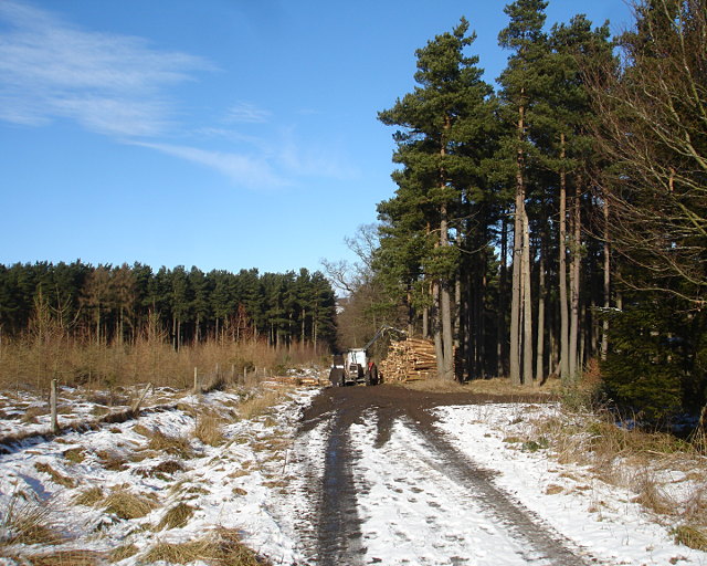
Photos Forestry operations in Gibbsneese plantation
‹ ›
Weather for this location Next 14 days Nearby places Useful places within 5 km
All Historic
Own or manage this place?
Claim this listing to keep details accurate, add photos, and highlight what makes it special — free.
Claim this page→ How useful was the information on this page?
Something wrong on this page?
id: e9c01faa-b517-4e34-996f-4fa97d9bfaff
UK green spaces mapped from open public data — so anyone can find the woodland, trail, or nature reserve closest to them.
© 2026 Glade · Made with care for UK green spaces
Wildlife to spot
2,331 records · National Biodiversity Network
▾
Wildlife to spot 2,331 records · National Biodiversity Network 🐦 Birds 32 species
winter spring summer
2025 ▾
Starling · Dunnock · Blue Tit · Swallow · Chaffinch +27
Starling Sturnus vulgaris2024 Dunnock Prunella modularis2023 Blue Tit Cyanistes caeruleus Swallow Hirundo rustica Chaffinch Fringilla coelebs2024 Jackdaw Coloeus monedula Carrion Crow Corvus corone2024 Robin Erithacus rubecula2024 Blackbird Turdus merula2024 Siskin Spinus spinus2022 House Martin Delichon urbicum2024 Pied Wagtail Motacilla alba yarrellii2024 Great Tit Parus major2024 Woodpigeon Columba palumbus2024 Stock Dove Columba oenas2023 House Sparrow Passer domesticus2022 Lesser Redpoll Acanthis flammea cabaret2022 Woodcock Scolopax rusticola Goldfinch Carduelis carduelis2024 Skylark Alauda arvensis2024 Curlew Numenius arquata2024 Black-headed Gull Chroicocephalus ridibundus2024 Common Gull Larus canus2024 Lapwing Vanellus vanellus2024 Herring Gull Larus argentatus2024 Wren Troglodytes troglodytes2024 Great Spotted Woodpecker Dendrocopos major2023 Pheasant Phasianus colchicus2023 Grey Partridge Perdix perdix2023 Pied Flycatcher Ficedula hypoleuca2023 Collared Dove Streptopelia decaocto2022 Greenfinch Chloris chloris2022 Common Lizard
Common Lizard Zootoca vivipara Orange-tip · Speckled Wood · Small White · Green-veined White · Common Carder Bee
Orange-tip Anthocharis cardamines Speckled Wood Pararge aegeria Small White Pieris rapae Green-veined White Pieris napi Common Carder Bee Bombus pascuorum Dog's Mercury · Red Campion · Wood Speedwell · Meadow Buttercup · Norway Spruce +87
Dog's Mercury Mercurialis perennis Red Campion Silene dioica Wood Speedwell Veronica montana Meadow Buttercup Ranunculus acris Norway Spruce Picea abies Creeping Buttercup Ranunculus repens Sessile Oak Quercus petraea Species observations from the last 10 years via NBN Atlas
Holly Ilex aquifolium
Holly Ilex aquifolium
Cow Parsley Anthriscus sylvestris
Cow Parsley Anthriscus sylvestris
Ramsons Allium ursinum
Ramsons Allium ursinum
Cock's-foot Dactylis glomerata
Cock's-foot Dactylis glomerata
Wood Avens Geum urbanum
Wood Avens Geum urbanum
Lesser Celandine Ficaria verna
Lesser Celandine Ficaria verna
Herb-Robert Geranium robertianum
Herb-Robert Geranium robertianum
Great Wood-rush Luzula sylvatica
Great Wood-rush Luzula sylvatica
Scots Pine Pinus sylvestris
Scots Pine Pinus sylvestris
Broad Buckler-fern Dryopteris dilatata
Broad Buckler-fern Dryopteris dilatata
Cleavers Galium aparine
Cleavers Galium aparine
Silver Birch Betula pendula
Silver Birch Betula pendula
Soft-rush Juncus effusus
Soft-rush Juncus effusus
Bulbous Buttercup Ranunculus bulbosus
Bulbous Buttercup Ranunculus bulbosus
Beech Fagus sylvatica
Beech Fagus sylvatica
Bramble Rubus fruticosus
Bramble Rubus fruticosus
Hard-fern Blechnum spicant
Hard-fern Blechnum spicant
Opposite-leaved Golden-saxifrage Chrysosplenium oppositifolium
Opposite-leaved Golden-saxifrage Chrysosplenium oppositifolium
Broad-leaved Everlasting-pea Lathyrus latifolius2023
Broad-leaved Everlasting-pea Lathyrus latifolius2023
Meadow Vetchling Lathyrus pratensis2023
Meadow Vetchling Lathyrus pratensis2023
Heath Speedwell Veronica officinalis2023
Heath Speedwell Veronica officinalis2023
Water Avens Geum rivale
Water Avens Geum rivale
Bluebell Hyacinthoides non-scripta
Bluebell Hyacinthoides non-scripta
Early Dog-violet Viola reichenbachiana
Early Dog-violet Viola reichenbachiana
Germander Speedwell Veronica chamaedrys
Germander Speedwell Veronica chamaedrys
Common Whitlowgrass Erophila verna
Common Whitlowgrass Erophila verna
Great Mullein Verbascum thapsus
Great Mullein Verbascum thapsus
Lamiastrum galeobdolon subsp. argentatum Lamiastrum galeobdolon subsp. argentatum
Lamiastrum galeobdolon subsp. argentatum Lamiastrum galeobdolon subsp. argentatum
Compact Rush Juncus conglomeratus
Compact Rush Juncus conglomeratus
Meadowsweet Filipendula ulmaria
Meadowsweet Filipendula ulmaria
Foxglove Digitalis purpurea
Foxglove Digitalis purpurea
Asplenium trichomanes subsp. quadrivalens Asplenium trichomanes subsp. quadrivalens
Asplenium trichomanes subsp. quadrivalens Asplenium trichomanes subsp. quadrivalens
Ivy Hedera helix
Ivy Hedera helix
Bilberry Vaccinium myrtillus
Bilberry Vaccinium myrtillus
Ribwort Plantain Plantago lanceolata
Ribwort Plantain Plantago lanceolata
Pignut Conopodium majus
Pignut Conopodium majus
Lawson Cypress Cupressus lawsoniana
Lawson Cypress Cupressus lawsoniana
Yorkshire-fog Holcus lanatus
Yorkshire-fog Holcus lanatus
Tufted Hair-grass Deschampsia cespitosa
Tufted Hair-grass Deschampsia cespitosa
Ground-elder Aegopodium podagraria
Ground-elder Aegopodium podagraria
Alternate-leaved Golden-saxifrage Chrysosplenium alternifolium
Alternate-leaved Golden-saxifrage Chrysosplenium alternifolium
Selfheal Prunella vulgaris
Selfheal Prunella vulgaris
Alder Alnus glutinosa
Alder Alnus glutinosa
Snowdrop Galanthus nivalis
Snowdrop Galanthus nivalis
Bush Vetch Vicia sepium
Bush Vetch Vicia sepium
Common Nettle Urtica dioica
Common Nettle Urtica dioica
Aubretia Aubrieta deltoidea
Aubretia Aubrieta deltoidea
Daisy Bellis perennis
Daisy Bellis perennis
Common Ragwort Jacobaea vulgaris
Common Ragwort Jacobaea vulgaris
Purple Toadflax Linaria purpurea
Purple Toadflax Linaria purpurea
Yellow Corydalis Pseudofumaria lutea
Yellow Corydalis Pseudofumaria lutea
Lords-and-Ladies Arum maculatum
Lords-and-Ladies Arum maculatum
Male-fern Dryopteris filix-mas
Male-fern Dryopteris filix-mas
Ash Fraxinus excelsior
Ash Fraxinus excelsior
Hawthorn Crataegus monogyna
Hawthorn Crataegus monogyna
Heather Calluna vulgaris
Heather Calluna vulgaris
Lady-fern Athyrium filix-femina
Lady-fern Athyrium filix-femina
Wall-rue Asplenium ruta-muraria
Wall-rue Asplenium ruta-muraria
Dame's-violet Hesperis matronalis
Dame's-violet Hesperis matronalis
Common Figwort Scrophularia nodosa
Common Figwort Scrophularia nodosa
Feverfew Tanacetum parthenium
Feverfew Tanacetum parthenium
American Willowherb Epilobium ciliatum
American Willowherb Epilobium ciliatum
Wood Burdock Arctium nemorosum
Wood Burdock Arctium nemorosum
White Clover Trifolium repens
White Clover Trifolium repens
Heath Bedstraw Galium saxatile
Heath Bedstraw Galium saxatile
Hogweed Heracleum sphondylium
Hogweed Heracleum sphondylium
Common Dog-violet Viola riviniana
Common Dog-violet Viola riviniana
Wood-sorrel Oxalis acetosella
Wood-sorrel Oxalis acetosella
Gorse Ulex europaeus
Gorse Ulex europaeus
Slender St John's-wort Hypericum pulchrum
Slender St John's-wort Hypericum pulchrum
Common Mouse-ear Cerastium fontanum
Common Mouse-ear Cerastium fontanum
Garlic Mustard Alliaria petiolata
Garlic Mustard Alliaria petiolata
Bracken Pteridium aquilinum
Bracken Pteridium aquilinum
Tormentil Potentilla erecta
Tormentil Potentilla erecta
Honeysuckle Lonicera periclymenum
Honeysuckle Lonicera periclymenum
Hybrid Larch Larix decidua x kaempferi = L. x marschlinsii
Hybrid Larch Larix decidua x kaempferi = L. x marschlinsii
Black Medick Medicago lupulina
Black Medick Medicago lupulina
Thyme-leaved Speedwell Veronica serpyllifolia
Thyme-leaved Speedwell Veronica serpyllifolia
Biting Stonecrop Sedum acre
Biting Stonecrop Sedum acre
Hairy Wood-rush Luzula pilosa
Hairy Wood-rush Luzula pilosa
Hard Shield-fern Polystichum aculeatum
Hard Shield-fern Polystichum aculeatum
Barren Strawberry Potentilla sterilis
Barren Strawberry Potentilla sterilis
Hairy Bitter-cress Cardamine hirsuta
Hairy Bitter-cress Cardamine hirsuta
Quaking-grass Briza media2023
Quaking-grass Briza media2023
Hart's-Tongue Asplenium scolopendrium2023
Hart's-Tongue Asplenium scolopendrium2023 Events & activities nearby Switch provider to compare local events, tours and bookable activities.
Bookable tours GetYourGuide Promote here