Grange Wood ✦ Ancient woodland 28 ha
🦉 Wildlife🦅 Birds🍂 Seasonal
↑ Share
Public access Free entry Dogs welcome 28 ha
Places › England › North East › County Durham Getting here
54.79664, -1.54082
Open directionsv Visiting this summer
Seasonal nature notes and what to look for now
▾ 🌞 Midsummer — early morning visits most comfortable; look for deer fawns in quieter clearings 🐕 Early mornings are best for dog walks in summer — visit before 9am to avoid the heat and find quieter trails 🅿️ Belmont Car Park 11m away — 20 car parks within reach 🌤️ Visiting this summer
🌞 Midsummer — early morning visits most comfortable; look for deer fawns in quieter clearings 🐕 Early mornings are best for dog walks in summer — visit before 9am to avoid the heat and find quieter trails 🅿️ Belmont Car Park 11m away — 20 car parks within reach £ Free to visit — no entry charge🐕 Dogs welcome🌿 Ancient woodland — rare wildlife habitat🚲 Bike parking🅿️ Parking· Paid
🦉 Wildlife
Very strong match
Multi-group wildlife — Amphibians, Birds, Mammals; Multi-group wildlife — Amphibians, Birds, Mammals
Free
🦅 Bird watching
Very strong match
Birds — Robin, Blue Tit, Mallard +65 more · last seen 2026; Birds — Robin, Blue Tit, Mallard +65 more · last seen 2026
Free
🍂 Seasonal nature
Strong match
Ancient woodland — bluebells, fungi and autumn colour; Plants — Gorse, Groundsel, Daisy +83 more · last seen 2026
Free
🦋 Insect spotting
Strong match
Lowland heathland — silver-studded blue and heath fritillary butterflies; Insects — Common Blue Damselfly, Blue-tailed Damselfly, Small Red-eyed Damselfly +39 more · last seen 2025
Free
Dogs allowed — public woodland
Free
Plants — White Dead-nettle, Red Dead-nettle, Common Nettle +8 more foraging species; Deciduous woodland — fungi, berries and wild garlic
Varies
Trails nearby Within roughly 5 km 26 signed routes nearby · 34 public paths nearby
Signed route nearby Public paths
Weardale Way Walking route 124 km ▾
Named route Length 124 km Regional walking route
Show on map Small Pilgrim Places Walking route 14.5 km ▾
Named route Length 14.5 km Round trip Local walking route
Show on map Jubilee Walk Walking route ▾
Named route Round trip Local walking route
Show on map Houghall Discovery Trail Walking route ▾
Named route Round trip Local walking route
Show on map Battle of Neville's Cross Walking route ▾
Named route Round trip Local walking route
Show on map 66 signed routes nearby
Signed route nearby
Walney to Wear Cycle Route Cycling route ▾
Named route Ref 70 National Cycle Network
Show on map Route 14 Cycling route ▾
Named route Ref 14 National Cycle Network
Show on map Great North Cycleway Cycling route ▾
Named route Ref 725 National Cycle Network
Show on map Great North Cycleway Cycling route ▾
Named route Ref 725 National Cycle Network
Show on map Langley Park to Sniperly Link Cycling route ▾
Named route Local cycle route
Show on map National Byway (County Durham and Northumberland) Cycling route ▾
The National Byway route through County Durham and Northumberland
Named route Ref NB Regional cycle route
Show on map 4 public paths nearby
Public paths
Frankland Lane bridleway · 1 km ▾
Public path bridleway Length 1 km Surface asphalt Path type: bridleway
Show on map ✦ Ancient woodland — continuously wooded since at least 1600 AD. A rare and irreplaceable habitat, rich in biodiversity and historical character.
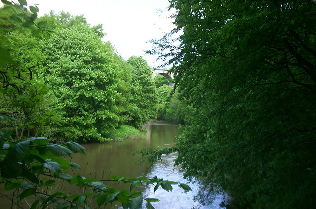
Photos Kepier Wood & Belmont Viaduct
‹ ›
Weather for this location Next 14 days Nearby places Useful places within 5 km
All Historic
Own or manage this place?
Claim this listing to keep details accurate, add photos, and highlight what makes it special — free.
Claim this page→ How useful was the information on this page?
Something wrong on this page?
id: 147a0a83-9c96-4603-95cb-c56c77ac05f3
UK green spaces mapped from open public data — so anyone can find the woodland, trail, or nature reserve closest to them.
© 2026 Glade · Made with care for UK green spaces
Wildlife to spot
36,380 records · National Biodiversity Network
▾
Wildlife to spot 36,380 records · National Biodiversity Network Robin · Blue Tit · Woodpigeon · Mallard · Redwing +37
Robin Erithacus rubecula Blue Tit Cyanistes caeruleus Woodpigeon Columba palumbus Mallard Anas platyrhynchos Redwing Turdus iliacus Blackbird Turdus merula Tufted Duck Aythya fuligula Long-tailed Tit Aegithalos caudatus Chaffinch Fringilla coelebs Little Grebe Tachybaptus ruficollis Coot Fulica atra Mute Swan Cygnus olor Magpie Pica pica Black-headed Gull Chroicocephalus ridibundus Dunnock Prunella modularis Greylag Goose Anser anser2025 Bullfinch Pyrrhula pyrrhula House Sparrow Passer domesticus Great Tit Parus major Coal Tit Periparus ater2025 Goldfinch Carduelis carduelis2025 Jackdaw Coloeus monedula2025 Treecreeper Certhia familiaris Wren Troglodytes troglodytes2025 Moorhen Gallinula chloropus2025 Collared Dove Streptopelia decaocto2025 Starling Sturnus vulgaris2025 Goldcrest Regulus regulus Carrion Crow Corvus corone2025 Lesser Redpoll Acanthis flammea cabaret2025 Kestrel Falco tinnunculus2025 Lapwing Vanellus vanellus Greenfinch Chloris chloris Grey Heron Ardea cinerea2025 Cormorant Phalacrocorax carbo2025 Mandarin Duck Aix galericulata2025 Song Thrush Turdus philomelos2025 Goldeneye Bucephala clangula2025 Jay Garrulus glandarius2025 Canada Goose Branta canadensis2025 Gadwall Mareca strepera2025 Woodcock Scolopax rusticola2025 Grey Squirrel
Grey Squirrel Sciurus carolinensis 7-spot Ladybird · Harlequin Ladybird
7-spot Ladybird Coccinella septempunctata Harlequin Ladybird Harmonia axyridis 🌿 Plants 20 species
winter spring
2026 ▾
Holly · Gorse · Ivy · Spear Thistle · Hart's-Tongue +15
Holly Ilex aquifolium2025 Gorse Ulex europaeus Ivy Hedera helix Spear Thistle Cirsium vulgare Hart's-Tongue Asplenium scolopendrium Great Wood-rush Luzula sylvatica Species observations from the last 10 years via NBN Atlas
Lesser Celandine
Lesser Celandine
Ficaria verna
Ficaria verna
Dog's Mercury Mercurialis perennis
Dog's Mercury Mercurialis perennis
Red Dead-nettle Lamium purpureum
Red Dead-nettle Lamium purpureum
Ramsons Allium ursinum
Ramsons Allium ursinum
Coltsfoot Tussilago farfara
Coltsfoot Tussilago farfara
Opposite-leaved Golden-saxifrage Chrysosplenium oppositifolium
Opposite-leaved Golden-saxifrage Chrysosplenium oppositifolium
Primrose Primula vulgaris
Primrose Primula vulgaris
Hazel Corylus avellana
Hazel Corylus avellana
Daisy Bellis perennis
Daisy Bellis perennis
Feverfew Tanacetum parthenium
Feverfew Tanacetum parthenium
Petty Spurge Euphorbia peplus
Petty Spurge Euphorbia peplus
White Dead-nettle Lamium album
White Dead-nettle Lamium album
Common Nettle Urtica dioica2025
Common Nettle Urtica dioica2025
Heather Calluna vulgaris2025
Heather Calluna vulgaris2025 Events & activities nearby Switch provider to compare local events, tours and bookable activities.
Bookable tours GetYourGuide Promote here