Plan your visit
🦅 Birds🦉 Wildlife✦ Heritage
Public access Dogs welcome 42 ha
Getting here
53.77315, -2.69848
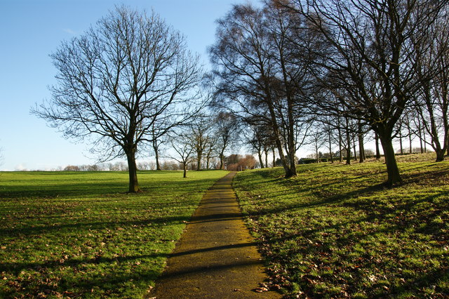
Open directionsv Moor Park is a large park to the north of the city centre of Preston, Lancashire, England. Moor Park is also the name of the electoral ward covering the park and the surrounding area. The ward borders the traditional boundary of Fulwood.
Read more on Wikipedia → Park Grade II* listed park and garden
Visiting this summer
Seasonal nature notes and what to look for now
▾ 🐦 42+ species recorded in this area — summer evenings are best for activity; watch for Rock Dove and Woodpigeon ✦ Historic character is a year-round quality here — summer brings its own atmosphere to the setting 🛝 Playground 135m away — built-in entertainment for younger visitors alongside the wider site 🌤️ Visiting this summer
🐦 42+ species recorded in this area — summer evenings are best for activity; watch for Rock Dove and Woodpigeon ✦ Historic character is a year-round quality here — summer brings its own atmosphere to the setting 🛝 Playground 135m away — built-in entertainment for younger visitors alongside the wider site 🦅 Bird watching
Very strong match
Birds — Rock Dove, Woodpigeon, Magpie +39 more · last seen 2025; Deciduous woodland — woodpeckers, warblers and woodland birds
Free
Birds — Rock Dove, Woodpigeon, Magpie +39 more · last seen 2025; Deciduous woodland priority habitat
Free
Historic site with public access
Free
🦋 Insect spotting
Strong match
Insects — Western Honey Bee, 7-spot Ladybird, Harmonia axyridis form succinea +43 more · last seen 2026
Free
🍂 Seasonal nature
Strong match
Plants — Butterfly-bush, Herb-Robert, Oxford Ragwort +199 more · last seen 2026
Free
Trails nearby Within roughly 5 km 2 signed routes nearby · 9 public paths nearby
Signed route nearby Public paths
Ribble Way Walking route 114 km ▾
The Ribble Way follows the valley of the River Ribble from the mouth to the source near to the Pennine Way National Trail on Gayle Moor.
Named route Length 114 km Regional walking route
Show on map Preston Guild Wheel Walking route ▾
Relation for walking route. The Cycling relation is separately mapped as NCN 622
Named route Round trip Local walking route
Show on map Porter Street Footbridge public footpath · 11 m ▾
Public path public footpath Length 11 m Path type: footway
Show on map Alan Kelly Walk public footpath · 74 m ▾
Public path public footpath Length 74 m Path type: footway
Show on map Alan Kelly Walk public footpath · 185 m ▾
Public path public footpath Length 185 m Path type: service
Show on map 259 signed routes nearby
Signed route nearby
Penwortham to Leyland Cycling route ▾
Named route Local cycle route
Show on map NCN 622 Preston Guild Wheel Cycling route ▾
Named route Ref 622 National Cycle Network
Show on map Route 62 Cycling route ▾
Named route Ref 62 National Cycle Network
Show on map NCN 622 (Low gradient route avoiding steep slope) Cycling route ▾
Named route Ref 622 National Cycle Network
Show on map NCN 622 (Steep gradient route) Cycling route ▾
Named route Ref 622 National Cycle Network
Show on map Route 6 Cycling route ▾
Named route Ref 6 National Cycle Network
Show on map
Weather for this location Next 14 days Nearby places Useful places within 5 km
All Historic
UK green spaces mapped from open public data — so anyone can find the woodland, trail, or nature reserve closest to them.
© 2026 Glade · Made with care for UK green spaces
Events & activities nearby Switch provider to compare local events, tours and bookable activities.
Bookable tours GetYourGuide Tripadvisor
Wildlife to spot
17,583 records · National Biodiversity Network
▾
Wildlife to spot 17,583 records · National Biodiversity Network 🐦 Birds 25 species
autumn winter
2025 ▾
Rock Dove · Black-headed Gull · Herring Gull · Woodpigeon · Magpie +20
Rock Dove Columba livia Black-headed Gull Chroicocephalus ridibundus Herring Gull Larus argentatus Woodpigeon Columba palumbus Magpie Pica pica Carrion Crow Corvus corone Lesser Black-backed Gull Larus fuscus Starling Sturnus vulgaris Jackdaw Coloeus monedula Robin Erithacus rubecula Blue Tit Cyanistes caeruleus Blackbird Turdus merula Goldfinch Carduelis carduelis Great Tit Parus major Grey Wagtail Motacilla cinerea Long-tailed Tit Aegithalos caudatus Mute Swan Cygnus olor House Sparrow Passer domesticus Wren Troglodytes troglodytes Chaffinch Fringilla coelebs Lapwing Vanellus vanellus Raven Corvus corax Pied Wagtail Motacilla alba yarrellii Redwing Turdus iliacus Collared Dove Streptopelia decaocto Grey Squirrel
Grey Squirrel Sciurus carolinensis 7-spot Ladybird · Harlequin Ladybird · Eristalis pertinax · Harmonia axyridis form conspicua · Harmonia axyridis form spectabilis +2
7-spot Ladybird Coccinella septempunctata Harlequin Ladybird Harmonia axyridis2025 Eristalis pertinax Eristalis pertinax2025 Harmonia axyridis form conspicua Harmonia axyridis form conspicua2025 Harmonia axyridis form spectabilis Harmonia axyridis form spectabilis2025 Lords-and-Ladies · Lesser Celandine · Herb-Robert · Ramsons · Ivy +32
Lords-and-Ladies Arum maculatum Lesser Celandine Ficaria verna Herb-Robert Geranium robertianum Ramsons Allium ursinum Ivy Hedera helix Garlic Mustard Alliaria petiolata Coltsfoot Tussilago farfara Species observations from the last 10 years via NBN Atlas
Harmonia axyridis form succinea
Harmonia axyridis form succinea
Harmonia axyridis form succinea2025
Harmonia axyridis form succinea2025
2-spot Ladybird Adalia bipunctata2025
2-spot Ladybird Adalia bipunctata2025
Snowdrop Galanthus nivalis
Snowdrop Galanthus nivalis
Cleavers Galium aparine
Cleavers Galium aparine
Field Forget-me-not Myosotis arvensis
Field Forget-me-not Myosotis arvensis
Common Field-speedwell Veronica persica
Common Field-speedwell Veronica persica
Shining Crane's-bill Geranium lucidum
Shining Crane's-bill Geranium lucidum
Hairy Bitter-cress Cardamine hirsuta
Hairy Bitter-cress Cardamine hirsuta
Shepherd's-purse Capsella bursa-pastoris
Shepherd's-purse Capsella bursa-pastoris
Wavy Bitter-cress Cardamine flexuosa
Wavy Bitter-cress Cardamine flexuosa
Ivy-leaved Toadflax Cymbalaria muralis
Ivy-leaved Toadflax Cymbalaria muralis
Common Whitlowgrass Erophila verna
Common Whitlowgrass Erophila verna
Cut-leaved Dead-nettle Lamium hybridum
Cut-leaved Dead-nettle Lamium hybridum
Senecio vulgaris subsp. vulgaris Senecio vulgaris subsp. vulgaris
Senecio vulgaris subsp. vulgaris Senecio vulgaris subsp. vulgaris
Hedge Mustard Sisymbrium officinale
Hedge Mustard Sisymbrium officinale
Daisy Bellis perennis
Daisy Bellis perennis
Cow Parsley Anthriscus sylvestris
Cow Parsley Anthriscus sylvestris
Broad-leaved Dock Rumex obtusifolius
Broad-leaved Dock Rumex obtusifolius
Prunus cerasifera var. cerasifera Prunus cerasifera var. cerasifera
Prunus cerasifera var. cerasifera Prunus cerasifera var. cerasifera
Beech Fagus sylvatica
Beech Fagus sylvatica
Hemlock Water-dropwort Oenanthe crocata
Hemlock Water-dropwort Oenanthe crocata
Soft Shield-fern Polystichum setiferum
Soft Shield-fern Polystichum setiferum
Lamiastrum galeobdolon subsp. argentatum Lamiastrum galeobdolon subsp. argentatum
Lamiastrum galeobdolon subsp. argentatum Lamiastrum galeobdolon subsp. argentatum
Purple Toadflax Linaria purpurea
Purple Toadflax Linaria purpurea
Opposite-leaved Golden-saxifrage Chrysosplenium oppositifolium
Opposite-leaved Golden-saxifrage Chrysosplenium oppositifolium
Dandelion Taraxacum
Dandelion Taraxacum
Butterfly-bush Buddleja davidii
Butterfly-bush Buddleja davidii
Creeping Buttercup Ranunculus repens
Creeping Buttercup Ranunculus repens
Marsh-marigold Caltha palustris
Marsh-marigold Caltha palustris
Common Chickweed Stellaria media
Common Chickweed Stellaria media
Hazel Corylus avellana
Hazel Corylus avellana
Himalayan Balsam Impatiens glandulifera
Himalayan Balsam Impatiens glandulifera