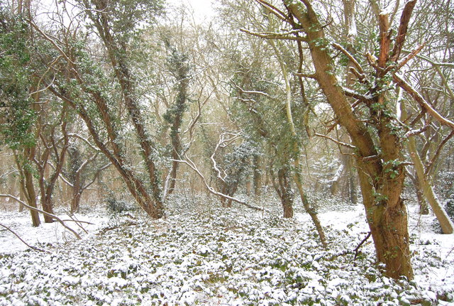
New England Wood ✦ Ancient woodland 24 ha
🦉 Wildlife🍂 Seasonal🦅 Birds
↑ Share
Public access Free entry Dogs welcome 24 ha
Places › England › Eastern › Rochford Getting here
51.58096, 0.63741
Open directionsv Visiting this summer
Seasonal nature notes and what to look for now
▾ 🌞 Midsummer — early morning visits most comfortable; look for deer fawns in quieter clearings 🐕 Early mornings are best for dog walks in summer — visit before 9am to avoid the heat and find quieter trails 🛝 Playground 286m away — built-in entertainment for younger visitors alongside the wider site 🌤️ Visiting this summer
🌞 Midsummer — early morning visits most comfortable; look for deer fawns in quieter clearings 🐕 Early mornings are best for dog walks in summer — visit before 9am to avoid the heat and find quieter trails 🛝 Playground 286m away — built-in entertainment for younger visitors alongside the wider site £ Free to visit — no entry charge🐕 Dogs welcome🌿 Ancient woodland — rare wildlife habitat🅿️ Parking· Free 🛝 Playground
🦉 Wildlife
Very strong match
Multi-group wildlife — Amphibians, Birds, Mammals, Reptiles; Multi-group wildlife — Amphibians, Birds, Mammals, Reptiles
Free
🍂 Seasonal nature
Strong match
Ancient woodland — bluebells, fungi and autumn colour; Plants — Corky-fruited Water-dropwort, Common Knapweed, Oxeye Daisy +6 more · last seen 2025
Free
🦅 Bird watching
Strong match
Birds — Magpie, Robin, Jay +46 more · last seen 2026; Birds — Magpie, Robin, Jay +46 more · last seen 2026
Free
🦋 Insect spotting
Strong match
Insects — Gatekeeper, Speckled Wood, Meadow Brown +137 more · last seen 2026; Insects — Gatekeeper, Speckled Wood, Meadow Brown +137 more · last seen 2026
Free
Dogs allowed — public woodland
Free
Trails nearby Within roughly 5 km 5 signed routes nearby · 17 public paths nearby
Signed route nearby Public paths
Accessible Route, Rayleigh Mount Walking route 600 m ▾
Gravel path with inclines around Rayleigh Mount.
AccessAble: https://www.accessable.co.uk/national-trust/access-guides/rayleigh-mount-the-mount-national-trust
Named route Length 600 m Duration 00:30 Round trip Local walking route
Show on map Blue Walk Walking route ▾
Roach Valley Walk Walking route ▾
Named route Local walking route
Show on map King Charles III England Coast Path: Tilbury to Southend-on-Sea Walking route ▾
Named route Ref ECP National walking route
Show on map Southend Ring Walking route ▾
Named route Local walking route
Show on map Eastwood Rise public footpath · 99 m ▾
Public path public footpath Length 99 m Surface compacted Path type: service
Show on map Eastwood Rise public footpath · 21 m ▾
Public path public footpath Length 21 m Surface concrete Path type: service
Show on map Eastwood Rise public footpath · 8 m ▾
Public path public footpath Length 8 m Surface asphalt Path type: service
Show on map 16 signed routes nearby
Signed route nearby
Prittle Brook Cycleway Cycling route ▾
Named route Local cycle route
Show on map National Cycle Route 16 (proposed) Cycling route ▾
Named route Ref 16 National Cycle Network
Show on map National Cycle Route 16 Cycling route ▾
Named route Ref 16 National Cycle Network
Show on map Route 53 Cycling route ▾
Named route Ref 53 Local cycle route
Show on map Route 57 Cycling route ▾
Named route Ref 57 Local cycle route
Show on map National Cycle Route 16 Cycling route ▾
Named route Ref 16 National Cycle Network
Show on map 2 public paths nearby
Public paths
No named routes yet. Public paths are shown on the map.
✦ Ancient woodland — continuously wooded since at least 1600 AD. A rare and irreplaceable habitat, rich in biodiversity and historical character.
Weather for this location Next 14 days Nearby places Useful places within 5 km
All Historic
Own or manage this place?
Claim this listing to keep details accurate, add photos, and highlight what makes it special — free.
Claim this page→ How useful was the information on this page?
Something wrong on this page?
id: 62b471fa-6b29-469d-a9c4-5163a2ae27a7
UK green spaces mapped from open public data — so anyone can find the woodland, trail, or nature reserve closest to them.
© 2026 Glade · Made with care for UK green spaces
Wildlife to spot
16,628 records · National Biodiversity Network
▾
Wildlife to spot 16,628 records · National Biodiversity Network 🐦 Birds 20 species
winter spring
2026 ▾
Robin · Magpie · Blackbird · Mallard · Long-tailed Tit +15
Robin Erithacus rubecula Magpie Pica pica Blackbird Turdus merula Mallard Anas platyrhynchos Long-tailed Tit Aegithalos caudatus Great Tit Parus major Great Spotted Woodpecker Dendrocopos major Blue Tit Cyanistes caeruleus Black-headed Gull Chroicocephalus ridibundus Jay Garrulus glandarius Goldfinch Carduelis carduelis2025 Wren Troglodytes troglodytes House Sparrow Passer domesticus Woodpigeon Columba palumbus Kestrel Falco tinnunculus Chaffinch Fringilla coelebs Pied Wagtail Motacilla alba Starling Sturnus vulgaris2025 Dunnock Prunella modularis2025 Blackcap Sylvia atricapilla2025 🦌 Mammals 5 species
winter spring summer autumn
2026 ▾
Grey Squirrel · Badger · Mole · Red Fox · Muntjac
Grey Squirrel Sciurus carolinensis Badger Meles meles Mole Talpa europaea2025 Red Fox Vulpes vulpes2025 Muntjac Muntiacus reevesi2025 🐸 Amphibians 2 species
spring summer
2026 ▾
Common Frog · Smooth Newt
Common Frog Rana temporaria Smooth Newt Lissotriton vulgaris 🐝 Insects 73 species
spring summer autumn
2026 ▾
7-spot Ladybird · Marmalade Hoverfly · Speckled Bush-cricket · Greater Bulb-Fly · Dock Bug +68
7-spot Ladybird Coccinella septempunctata Marmalade Hoverfly Episyrphus balteatus2025 Speckled Bush-cricket Leptophyes punctatissima2025 Greater Bulb-Fly Merodon equestris2025 Dock Bug Coreus marginatus Red Clover · Corky-fruited Water-dropwort · Common Knapweed · Oxeye Daisy · Goat's-beard
Red Clover Trifolium pratense Corky-fruited Water-dropwort Oenanthe pimpinelloides Common Knapweed Centaurea nigra Oxeye Daisy Leucanthemum vulgare Goat's-beard Tragopogon pratensis Species observations from the last 10 years via NBN Atlas
2025
2025
Batman Hoverfly Myathropa florea2025
Batman Hoverfly Myathropa florea2025
Cow Wheat Shieldbug Adomerus biguttatus
Cow Wheat Shieldbug Adomerus biguttatus
Hornet Hoverfly Volucella zonaria2025
Hornet Hoverfly Volucella zonaria2025
Orange Ladybird Halyzia sedecimguttata2025
Orange Ladybird Halyzia sedecimguttata2025
Hairy Shieldbug Dolycoris baccarum2025
Hairy Shieldbug Dolycoris baccarum2025
Dark Bush-cricket Pholidoptera griseoaptera2025
Dark Bush-cricket Pholidoptera griseoaptera2025
Glow-worm Lampyris noctiluca2025
Glow-worm Lampyris noctiluca2025
Red Wood Ant Formica rufa2025
Red Wood Ant Formica rufa2025
Rhopalus (Rhopalus) subrufus Rhopalus (Rhopalus) subrufus2025
Rhopalus (Rhopalus) subrufus Rhopalus (Rhopalus) subrufus2025
Green Shieldbug Palomena prasina2025
Green Shieldbug Palomena prasina2025
Tortoise Bug Eurygaster testudinaria2025
Tortoise Bug Eurygaster testudinaria2025
Eristalis pertinax Eristalis pertinax2025
Eristalis pertinax Eristalis pertinax2025
Meadow Grasshopper Pseudochorthippus parallelus2025
Meadow Grasshopper Pseudochorthippus parallelus2025
Syrphus Syrphus2025
Syrphus Syrphus2025
Sicus ferrugineus Sicus ferrugineus2025
Sicus ferrugineus Sicus ferrugineus2025
Red-headed Cardinal Beetle Pyrochroa serraticornis2025
Red-headed Cardinal Beetle Pyrochroa serraticornis2025
Cantharis rustica Cantharis rustica2025
Cantharis rustica Cantharis rustica2025
Red-legged Shieldbug Pentatoma rufipes2025
Red-legged Shieldbug Pentatoma rufipes2025
Green Nettle Weevil Phyllobius pomaceus2025
Green Nettle Weevil Phyllobius pomaceus2025
Calathus rotundicollis Calathus rotundicollis
Calathus rotundicollis Calathus rotundicollis
Stomis pumicatus Stomis pumicatus
Stomis pumicatus Stomis pumicatus
Leistus fulvibarbis Leistus fulvibarbis
Leistus fulvibarbis Leistus fulvibarbis
Leistus rufomarginatus Leistus rufomarginatus
Leistus rufomarginatus Leistus rufomarginatus
Cabbage Bug Eurydema (Eurydema) oleracea2025
Cabbage Bug Eurydema (Eurydema) oleracea2025
Andrion regensteinense Andrion regensteinense2025
Andrion regensteinense Andrion regensteinense2025
Empicoris rubromaculatus Empicoris rubromaculatus2025
Empicoris rubromaculatus Empicoris rubromaculatus2025
Gorse Shieldbug Piezodorus lituratus2025
Gorse Shieldbug Piezodorus lituratus2025
Acalypta parvula Acalypta parvula2025
Acalypta parvula Acalypta parvula2025
Harlequin Ladybird Harmonia axyridis2025
Harlequin Ladybird Harmonia axyridis2025
Drymus (Sylvadrymus) brunneus Drymus (Sylvadrymus) brunneus2025
Drymus (Sylvadrymus) brunneus Drymus (Sylvadrymus) brunneus2025
Scarce 7-spot Ladybird Coccinella magnifica2025
Scarce 7-spot Ladybird Coccinella magnifica2025
Orthotylus (Litocoris) ericetorum Orthotylus (Litocoris) ericetorum2025
Orthotylus (Litocoris) ericetorum Orthotylus (Litocoris) ericetorum2025
Pea-leaf Weevil Sitona lineatus2025
Pea-leaf Weevil Sitona lineatus2025
Ant Damsel Bug Himacerus (Aptus) mirmicoides2025
Ant Damsel Bug Himacerus (Aptus) mirmicoides2025
14-spot Ladybird Propylea quattuordecimpunctata2025
14-spot Ladybird Propylea quattuordecimpunctata2025
Nysius senecionis Nysius senecionis2025
Nysius senecionis Nysius senecionis2025
Nysius graminicola Nysius graminicola2025
Nysius graminicola Nysius graminicola2025
Conops quadrifasciatus Conops quadrifasciatus2025
Conops quadrifasciatus Conops quadrifasciatus2025
22-spot Ladybird Psyllobora vigintiduopunctata2025
22-spot Ladybird Psyllobora vigintiduopunctata2025
Eupeodes Eupeodes2025
Eupeodes Eupeodes2025
Volucella inanis Volucella inanis2025
Volucella inanis Volucella inanis2025
Marbled White Melanargia galathea2025
Marbled White Melanargia galathea2025
Kidney-spot Ladybird Chilocorus renipustulatus2025
Kidney-spot Ladybird Chilocorus renipustulatus2025
Common Red Soldier Beetle Rhagonycha fulva2025
Common Red Soldier Beetle Rhagonycha fulva2025
Volucella pellucens Volucella pellucens2025
Volucella pellucens Volucella pellucens2025
Red Admiral Vanessa atalanta2025
Red Admiral Vanessa atalanta2025
Cuckoo-Spit Insect Philaenus spumarius2025
Cuckoo-Spit Insect Philaenus spumarius2025
Chrysogaster solstitialis Chrysogaster solstitialis2025
Chrysogaster solstitialis Chrysogaster solstitialis2025
Heath Fritillary Melitaea athalia2025
Heath Fritillary Melitaea athalia2025
16-spot Ladybird Tytthaspis sedecimpunctata2025
16-spot Ladybird Tytthaspis sedecimpunctata2025
Clytra quadripunctata Clytra quadripunctata2025
Clytra quadripunctata Clytra quadripunctata2025
Meliscaeva auricollis Meliscaeva auricollis2025
Meliscaeva auricollis Meliscaeva auricollis2025
Dark-edged Bee-fly Bombylius major2025
Dark-edged Bee-fly Bombylius major2025
Athous haemorrhoidalis Athous haemorrhoidalis2025
Athous haemorrhoidalis Athous haemorrhoidalis2025
Black-headed Cardinal Beetle Pyrochroa coccinea2025
Black-headed Cardinal Beetle Pyrochroa coccinea2025
Xylota segnis Xylota segnis2025
Xylota segnis Xylota segnis2025
Nettle Pollen Beetle Brachypterus urticae2025
Nettle Pollen Beetle Brachypterus urticae2025
Western Honey Bee Apis mellifera2025
Western Honey Bee Apis mellifera2025
Oncopsis flavicollis Oncopsis flavicollis2025
Oncopsis flavicollis Oncopsis flavicollis2025
Cymus melanocephalus Cymus melanocephalus2025
Cymus melanocephalus Cymus melanocephalus2025
Rhyzobius litura Rhyzobius litura2025
Rhyzobius litura Rhyzobius litura2025
Bishop's Mitre Aelia acuminata2025
Bishop's Mitre Aelia acuminata2025
Stenodema (Stenodema) laevigata Stenodema (Stenodema) laevigata2025
Stenodema (Stenodema) laevigata Stenodema (Stenodema) laevigata2025
St Marks Fly Bibio marci2025
St Marks Fly Bibio marci2025
Bibio leucopterus Bibio leucopterus2025
Bibio leucopterus Bibio leucopterus2025
Empis tessellata Empis tessellata2025
Empis tessellata Empis tessellata2025
Platycheirus scutatus Platycheirus scutatus2025
Platycheirus scutatus Platycheirus scutatus2025
Cantharis pellucida Cantharis pellucida2025
Cantharis pellucida Cantharis pellucida2025 Events & activities nearby Switch provider to compare local events, tours and bookable activities.
Bookable tours GetYourGuide Promote here