Arnfield Covert - Open water
1 ha
〰Water🦉Wildlife🦅Birds
Public accessFree entryDogs welcome1 ha
Getting here
53.47566, -1.98928
Open directionsv
Visiting this summer
Seasonal nature notes and what to look for now
- 🌞Midsummer — dragonfly and damselfly activity peaks along water edges
- 🥾Walking is best here in early morning in summer — quiet trails and good light before the heat
- 🐕Dogs welcome — bring water in summer; the site has enough space to find shade on hot days
🌤️ Visiting this summer
- 🌞Midsummer — dragonfly and damselfly activity peaks along water edges
- 🥾Walking is best here in early morning in summer — quiet trails and good light before the heat
- 🐕Dogs welcome — bring water in summer; the site has enough space to find shade on hot days
- £Free to visit — no entry charge
- 🐕Dogs welcome
〰Waterside walks
Strong match
Open water — lake or pond with public access
Varies
Deciduous woodland priority habitat
Free
🦅Bird watching
Strong match
Deciduous woodland — woodpeckers, warblers and woodland birds
Free
Dogs allowed with public access
Free
Named hiking route nearby: Pennine Bridleway Interim Route for Walkers
Free
Deciduous woodland — fungi, berries and wild garlic
Varies
Trails nearby
Within roughly 5 km12 signed routes nearby · 5 public paths nearby
Signed route nearbyPublic paths
Tameside Trail (West - Broadbottom to Mossley)Walking route▾
Named routeLocal walking route
Oldham WayWalking route▾
Named routeLocal walking route
Tameside Trail (East - Broadbottom to Mossley)Walking route▾
Named routeLocal walking route
Pennine Way (Edale to Crowden)Walking route▾
Named routeNational walking route
Pennine Way (Crowden to Standedge)Walking route▾
Named routeNational walking route
48 signed routes nearby
Signed route nearby
Stalybridge & Diggle Loop LineCycling route▾
Named routeLocal cycle route
Trans Pennine TrailCycling route▾
Named routeRef 62National Cycle Network
Trans-Pennine TrailCycling route▾
Named routeRef TPTRegional cycle route
Saddleworth LinearCycling route▾
Named routeLocal cycle route
Trans Pennine TrailCycling route▾
Named routeRef 62National Cycle Network
Trans Pennine TrailCycling route▾
Named routeRef 62National Cycle Network
2 signed routes nearby
Signed route nearby
Great North Trail (Peak District and South Pennines)Mountain bike route130.4 km▾
Named routeLength 130.4 kmNational Cycle Network
Tame Valley LoopMountain bike route29 km▾
Named routeRef AdvancedLength 29 kmLocal cycle route
Photos
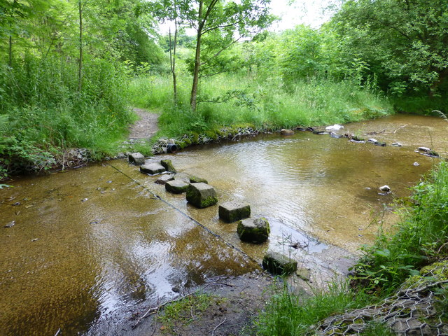
Stepping stones cross a feeder channel for Arnfield Reservoir
Weather for this location
Next 14 daysNearby places
Useful places within 5 km
Own or manage this place?
Claim this listing to keep details accurate, add photos, and highlight what makes it special — free.
Claim this page→How useful was the information on this page?
id: 6825dea6-1aad-444c-a3ac-573482bf934d
Sciurus carolinensis2025
Sciurus carolinensis2025
Brown HareLepus europaeus2025Brown HareLepus europaeus2025RabbitOryctolagus cuniculus2025RabbitOryctolagus cuniculus20252025
2025
Limnephilus lunatusLimnephilus lunatus2025Limnephilus lunatusLimnephilus lunatus2025Roesel's Bush-cricketRoeseliana roeselii2025Roesel's Bush-cricketRoeseliana roeselii2025Eristalis tenaxEristalis tenax2025Eristalis tenaxEristalis tenax2025Eupeodes lunigerEupeodes luniger2025Eupeodes lunigerEupeodes luniger2025Cuckoo-Spit InsectPhilaenus spumarius2025Cuckoo-Spit InsectPhilaenus spumarius2025Common Green GrasshopperOmocestus viridulus2025Common Green GrasshopperOmocestus viridulus2025Broad CenturionChloromyia formosa2025Broad CenturionChloromyia formosa2025Common Red Soldier BeetleRhagonycha fulva2025Common Red Soldier BeetleRhagonycha fulva2025Common Blue DamselflyEnallagma cyathigerum2025Common Blue DamselflyEnallagma cyathigerum2025Scoliocentra villosaScoliocentra villosaScoliocentra villosaScoliocentra villosaHairy ShieldbugDolycoris baccarumHairy ShieldbugDolycoris baccarumOdontocerum albicorneOdontocerum albicorneOdontocerum albicorneOdontocerum albicorneWestern Conifer Seed BugLeptoglossus occidentalis2025Western Conifer Seed BugLeptoglossus occidentalis2025Southern HawkerAeshna cyanea2025Southern HawkerAeshna cyanea2025Helina evectaHelina evecta2025Helina evectaHelina evecta2025Curved Birch Mining SawflyScolioneura betuleti2025Curved Birch Mining SawflyScolioneura betuleti2025Clay-coloured WeevilOtiorhynchus singularis2025Clay-coloured WeevilOtiorhynchus singularis2025Brown HawkerAeshna grandis2025Brown HawkerAeshna grandis2025Black DarterSympetrum danae2025Black DarterSympetrum danae2025Common DarterSympetrum striolatum2025Common DarterSympetrum striolatum2025Vine WeevilOtiorhynchus sulcatus2025Vine WeevilOtiorhynchus sulcatus2025Bibio pomonaeBibio pomonae2025Bibio pomonaeBibio pomonae2025Platycheirus scutatusPlatycheirus scutatus2025Platycheirus scutatusPlatycheirus scutatus2025Volucella inanisVolucella inanis2025Volucella inanisVolucella inanis2025Yellow-legged Black LegionnaireBeris morrisii2025Yellow-legged Black LegionnaireBeris morrisii2025Dasysyrphus albostriatusDasysyrphus albostriatus2025Dasysyrphus albostriatusDasysyrphus albostriatus2025Banded ClubhornAbia fasciata2025Banded ClubhornAbia fasciata2025Platycheirus albimanusPlatycheirus albimanus2025Platycheirus albimanusPlatycheirus albimanus2025Batman HoverflyMyathropa florea2025Batman HoverflyMyathropa florea2025Cicadella viridisCicadella viridis2025Cicadella viridisCicadella viridis2025Green ShieldbugPalomena prasina2025Green ShieldbugPalomena prasina2025Blue-tailed DamselflyIschnura elegans2025Blue-tailed DamselflyIschnura elegans2025Emerald DamselflyLestes sponsa2025Emerald DamselflyLestes sponsa2025Chrysotoxum bicinctumChrysotoxum bicinctum2025Chrysotoxum bicinctumChrysotoxum bicinctum2025Scaeva pyrastriScaeva pyrastri2025Scaeva pyrastriScaeva pyrastri202510-spot LadybirdAdalia decempunctata202510-spot LadybirdAdalia decempunctata20252-spot LadybirdAdalia bipunctata20252-spot LadybirdAdalia bipunctata2025Chrysogaster solstitialisChrysogaster solstitialis2025Chrysogaster solstitialisChrysogaster solstitialis2025Syrphus torvusSyrphus torvus2025Syrphus torvusSyrphus torvus2025Sericomyia silentisSericomyia silentis2025Sericomyia silentisSericomyia silentis2025Cercopis vulnerataCercopis vulnerata2025Cercopis vulnerataCercopis vulnerata2025Swollen-thighed BeetleOedemera nobilis2025Swollen-thighed BeetleOedemera nobilis2025Green Tiger BeetleCicindela campestris2025Green Tiger BeetleCicindela campestris2025CheilosiaCheilosia2025CheilosiaCheilosia2025Red-legged ShieldbugPentatoma rufipes2025Red-legged ShieldbugPentatoma rufipes2025Eristalis pertinaxEristalis pertinax2025Eristalis pertinaxEristalis pertinax2025Larder BeetleDermestes lardarius2025Larder BeetleDermestes lardarius2025Sorbus aucuparia2025
Sorbus aucuparia2025
Purple ToadflaxLinaria purpurea2025Purple ToadflaxLinaria purpurea2025Lady-fernAthyrium filix-femina2025Lady-fernAthyrium filix-femina2025TutsanHypericum androsaemum2025TutsanHypericum androsaemum2025Himalayan BalsamImpatiens glandulifera2025Himalayan BalsamImpatiens glandulifera2025Guelder-roseViburnum opulus2025Guelder-roseViburnum opulus2025HazelCorylus avellana2025HazelCorylus avellana2025Herb-RobertGeranium robertianum2025Herb-RobertGeranium robertianum2025Broad-leaved HelleborineEpipactis helleborine2025Broad-leaved HelleborineEpipactis helleborine2025Opium PoppyPapaver somniferum2025Opium PoppyPapaver somniferum2025Black MedickMedicago lupulina2025Black MedickMedicago lupulina2025ColumbineAquilegia vulgaris2025ColumbineAquilegia vulgaris2025BlackthornPrunus spinosaBlackthornPrunus spinosaBlack NightshadeSolanum nigrum2025Black NightshadeSolanum nigrum2025Zigzag CloverTrifolium medium2025Zigzag CloverTrifolium medium2025Wood AvensGeum urbanum2025Wood AvensGeum urbanum2025Wall CotoneasterCotoneaster horizontalis2025Wall CotoneasterCotoneaster horizontalis2025Common NettleUrtica dioica2025Common NettleUrtica dioica2025AshFraxinus excelsior2025AshFraxinus excelsior2025Alsike CloverTrifolium hybridum2025Alsike CloverTrifolium hybridum2025NipplewortLapsana communis2025NipplewortLapsana communis2025SnapdragonAntirrhinum majus2025SnapdragonAntirrhinum majus2025Red ValerianCentranthus ruber2025Red ValerianCentranthus ruber2025Cherry LaurelPrunus laurocerasus2025Cherry LaurelPrunus laurocerasus2025Yellow LoosestrifeLysimachia vulgaris2025Yellow LoosestrifeLysimachia vulgaris2025Marsh WoundwortStachys palustris2025Marsh WoundwortStachys palustris2025Wall SpeedwellVeronica arvensis2025Wall SpeedwellVeronica arvensis2025Creeping ThistleCirsium arvense2025Creeping ThistleCirsium arvense2025MeadowsweetFilipendula ulmaria2025MeadowsweetFilipendula ulmaria2025Hedge WoundwortStachys sylvatica2025Hedge WoundwortStachys sylvatica2025Perforate St John's-wortHypericum perforatum2025Perforate St John's-wortHypericum perforatum2025HeatherCalluna vulgaris2025HeatherCalluna vulgaris2025Dotted LoosestrifeLysimachia punctata2025Dotted LoosestrifeLysimachia punctata2025Common FigwortScrophularia nodosa2025Common FigwortScrophularia nodosa2025Reflexed StonecropPetrosedum rupestre2025Reflexed StonecropPetrosedum rupestre2025Heath BedstrawGalium saxatile2025Heath BedstrawGalium saxatile2025Hemp-agrimonyEupatorium cannabinum2025Hemp-agrimonyEupatorium cannabinum2025Black SpleenwortAsplenium adiantum-nigrum2025Black SpleenwortAsplenium adiantum-nigrum2025Great BurnetSanguisorba officinalis2025Great BurnetSanguisorba officinalis2025Rosebay WillowherbChamaenerion angustifolium2025Rosebay WillowherbChamaenerion angustifolium2025Common Field-speedwellVeronica persica2025Common Field-speedwellVeronica persica2025Petty SpurgeEuphorbia peplus2025Petty SpurgeEuphorbia peplus2025Bush VetchVicia sepium2025Bush VetchVicia sepium2025Lady's BedstrawGalium verum2025Lady's BedstrawGalium verum2025Curled DockRumex crispus2025Curled DockRumex crispus2025Marsh RagwortJacobaea aquatica2025Marsh RagwortJacobaea aquatica2025Perennial Rye-grassLolium perenne2025Perennial Rye-grassLolium perenne2025RaspberryRubus idaeus2025RaspberryRubus idaeus2025WoodruffGalium odoratum2025WoodruffGalium odoratum2025French Crane's-billGeranium endressii2025French Crane's-billGeranium endressii2025DogwoodCornus sanguinea2025DogwoodCornus sanguinea2025Dryopteris filix-masDryopteris filix-mas2025Dryopteris filix-masDryopteris filix-mas2025Polygonum avicularePolygonum aviculare2025Polygonum avicularePolygonum aviculare2025YewTaxus baccata2025YewTaxus baccata2025AlderAlnus glutinosa2025AlderAlnus glutinosa2025Hedge MustardSisymbrium officinale2025Hedge MustardSisymbrium officinale2025Fox-and-cubsPilosella aurantiaca2025Fox-and-cubsPilosella aurantiaca2025Red CloverTrifolium pratense2025Red CloverTrifolium pratense2025Common Bird's-foot-trefoilLotus corniculatus2025Common Bird's-foot-trefoilLotus corniculatus2025Japanese KnotweedReynoutria japonica2025Japanese KnotweedReynoutria japonica2025Lesser CelandineFicaria verna2025Lesser CelandineFicaria verna2025BugleAjuga reptans2025BugleAjuga reptans2025HoneysuckleLonicera periclymenum2025HoneysuckleLonicera periclymenum2025Wild StrawberryFragaria vesca2025Wild StrawberryFragaria vesca2025Opposite-leaved Golden-saxifrageChrysosplenium oppositifolium2025Opposite-leaved Golden-saxifrageChrysosplenium oppositifolium2025BluebellHyacinthoides non-scripta2025BluebellHyacinthoides non-scripta2025BrooklimeVeronica beccabunga2025BrooklimeVeronica beccabunga2025Events & activities nearby
Switch provider to compare local events, tours and bookable activities.