Plan your visit
🦅Birds✦Heritage🦉Wildlife
Public accessDogs welcome98 ha
Getting here
50.63086, -3.51437
Open directionsv
Visiting this summer
Seasonal nature notes and what to look for now
- 🐦61+ species recorded in this area — summer evenings are best for activity; watch for Woodpigeon and Blackbird
- ✦Historic character is a year-round quality here — summer brings its own atmosphere to the setting
- 🐕Dogs welcome — bring water in summer; the site has enough space to find shade on hot days
🌤️ Visiting this summer
- 🐦61+ species recorded in this area — summer evenings are best for activity; watch for Woodpigeon and Blackbird
- ✦Historic character is a year-round quality here — summer brings its own atmosphere to the setting
- 🐕Dogs welcome — bring water in summer; the site has enough space to find shade on hot days
🦅Bird watching
Very strong match
Birds — Woodpigeon, Blackbird, Chaffinch +58 more · last seen 2026; Deciduous woodland — woodpeckers, warblers and woodland birds
Free
Historic site with public access; Grade II* listed building: THE WHITE BRIDGE
Free
Birds — Woodpigeon, Blackbird, Chaffinch +58 more · last seen 2026; Deciduous woodland priority habitat
Free
🍄Mushroom foraging
Strong match
Fungi — Opegrapha vermicellifera, Melanohalea exasperatula, Ramalina calicaris +86 more · last seen 2014
Varies
🦋Insect spotting
Strong match
Insects — Meadow Brown, Speckled Wood, Red Admiral +125 more · last seen 2026
Free
🍂Seasonal nature
Strong match
Plants — Bluebell, Holly, Hazel +157 more · last seen 2019
Free
Trails nearby
Within roughly 5 km13 signed routes nearby
Signed route nearby
Two Counties WayWalking route90 km▾
A long distance walk of 56 miles (90km) from Taunton to Starcross on the Exe estuary.
Named routeRef TCWLength 90 kmRegional walking route
Exe Valley WayWalking route▾
Named routeRef EVWRegional walking route
South West Coast Path (Section 43: Babbacombe to Exmouth)Walking route▾
Named routeRef SWCPNational walking route
Teignmouth & Dawlish WayWalking route▾
Named routeRef TDWLocal walking route
Exminster to KentonWalking route▾
Named routeRef EXK
36 signed routes nearby
Signed route nearby
National Cycle Route 2 Axminster to DawlishCycling route▾
Named routeRef 2National Cycle Network
Main RouteCycling route2.1 km▾
Named routeRef 2Length 2.1 kmNational Cycle NetworkOn-roadSurface asphalt
Main RouteCycling route52 m▾
Named routeRef 2Length 52 mNational Cycle NetworkTraffic-freeSurface asphalt
Main RouteCycling route82 m▾
Named routeRef 2Length 82 mNational Cycle NetworkTraffic-freeSurface asphalt
Main RouteCycling route345 m▾
Named routeRef 2Length 345 mNational Cycle NetworkOn-roadSurface asphalt
Main RouteCycling route85 m▾
Named routeRef 2Length 85 mNational Cycle NetworkTraffic-freeSurface asphalt
5 signed routes nearby
Signed route nearby
Ridge Ride Trail (Red - Difficult)Mountain bike route▾
Named routeRef Ridge Ride Red
Discovery Trail (Green - Easy)Mountain bike route▾
Named routeRef Discovery - green easy
Ridge Ride Extreme (Black - Severe)Mountain bike route▾
Named routeRef Ridge Ride BlackLocal cycle route
Spicers Trail (Blue - moderate)Mountain bike route▾
Named routeRef Spicers - blue moderate
Kiddens Trail (Blue - moderate)Mountain bike route▾
Named routeRef Kiddens Trail (Blue - moderate)
5 public paths nearby
Public paths
Holloway Lanebridleway · 79 m▾
Public pathbridlewayLength 79 mSurface mudPath type: track
Holloway Lanebridleway · 898 m▾
Public pathbridlewayLength 898 mPath type: track
Holloway Lanebridleway · 74 m▾
Public pathbridlewayLength 74 mPath type: track
Holloway Lanebridleway · 400 m▾
Public pathbridlewayLength 400 mPath type: track
Photos
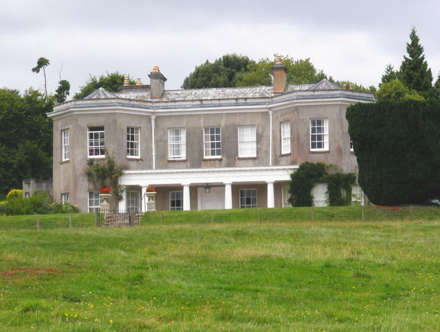
Front elevation, Oxton House
Weather for this location
Next 14 daysNearby places
Useful places within 5 km
Events & activities nearby
Switch provider to compare local events, tours and bookable activities.
Wildlife to spot
2,223 records · National Biodiversity Network
Wildlife to spot
2,223 records · National Biodiversity Network🐦Birds35 species
springautumn
2026▾
Chaffinch · Blackbird · Robin · Coal Tit · Treecreeper +30
- ChaffinchFringilla coelebs2025
- BlackbirdTurdus merula2025
- RobinErithacus rubecula2025
- Coal TitPeriparus ater2025
- TreecreeperCerthia familiaris2025
- WrenTroglodytes troglodytes
- GoldcrestRegulus regulus2025
- ChiffchaffPhylloscopus collybita2025
- CrossbillLoxia curvirostra2025
- Great Spotted WoodpeckerDendrocopos major2025
- Blue TitCyanistes caeruleus2025
- FirecrestRegulus ignicapilla2025
- WoodpigeonColumba palumbus2025
- PheasantPhasianus colchicus2025
- Carrion CrowCorvus corone2025
- SiskinSpinus spinus2025
- Tawny OwlStrix aluco2024
- DunnockPrunella modularis2025
- Long-tailed TitAegithalos caudatus2025
- BlackcapSylvia atricapilla2025
- NuthatchSitta europaea2025
- CootFulica atra
- MoorhenGallinula chloropus
- MallardAnas platyrhynchos
- MagpiePica pica
- Mute SwanCygnus olor
- RavenCorvus corax2025
- Herring GullLarus argentatus2025
- Spotted FlycatcherMuscicapa striata2025
- BullfinchPyrrhula pyrrhula2025
- Mistle ThrushTurdus viscivorus2025
- Willow WarblerPhylloscopus trochilus2025
- Great TitParus major2023
- GoldfinchCarduelis carduelis2023
- StonechatSaxicola rubicola2023
Common Pipistrelle · Hazel Dormouse · Soprano Pipistrelle · Nyctalus/Eptesicus agg.
- Common PipistrellePipistrellus pipistrellus
- Hazel DormouseMuscardinus avellanarius
- Soprano PipistrellePipistrellus pygmaeus
- Nyctalus/Eptesicus agg.Nyctalus/Eptesicus agg.
Slow-worm
🐸Amphibians1 species
autumn
2021▾
Common Toad
Marmalade Hoverfly · Leptura aurulenta · Black Oil-beetle · Helophilus pendulus · Glow-worm +3
- Marmalade HoverflyEpisyrphus balteatus
- Leptura aurulentaLeptura aurulenta2025
- Black Oil-beetleMeloe proscarabaeus2025
- Helophilus pendulusHelophilus pendulus2024
- Glow-wormLampyris noctiluca2024
- Harlequin LadybirdHarmonia axyridis
Rough Chervil · Sweet Chestnut · Broad Buckler-fern · Trailing St John's-wort · Broad-leaved Willowherb +82
- Rough ChervilChaerophyllum temulum
- Sweet ChestnutCastanea sativa
- Broad Buckler-fernDryopteris dilatata
- Trailing St John's-wortHypericum humifusum
- Broad-leaved WillowherbEpilobium montanum
- Cock's-footDactylis glomerata
- Dog-rose
Species observations from the last 10 years via NBN Atlas
2022
2022
Wasp BeetleClytus arietis2021Wasp BeetleClytus arietis2021Common Red Soldier BeetleRhagonycha fulva2021Common Red Soldier BeetleRhagonycha fulva2021Rosa canina
Rosa canina
Hedge BedstrawGalium albumHedge BedstrawGalium albumHoneysuckleLonicera periclymenumHoneysuckleLonicera periclymenumHazelCorylus avellanaHazelCorylus avellanaRadishRaphanus raphanistrumRadishRaphanus raphanistrumGermander SpeedwellVeronica chamaedrysGermander SpeedwellVeronica chamaedrysCommon NettleUrtica dioicaCommon NettleUrtica dioicaGround-ivyGlechoma hederaceaGround-ivyGlechoma hederaceaElderSambucus nigraElderSambucus nigraPerennial Rye-grassLolium perennePerennial Rye-grassLolium perenneHedge BindweedCalystegia sepiumHedge BindweedCalystegia sepiumCommon BentAgrostis capillarisCommon BentAgrostis capillarisDryopteris affinisDryopteris affinisDryopteris affinisDryopteris affinisWood SpeedwellVeronica montanaWood SpeedwellVeronica montanaThyme-leaved SpeedwellVeronica serpyllifoliaThyme-leaved SpeedwellVeronica serpyllifoliaWood Meadow-grassPoa nemoralisWood Meadow-grassPoa nemoralisSheep's SorrelRumex acetosellaSheep's SorrelRumex acetosellaRibwort PlantainPlantago lanceolataRibwort PlantainPlantago lanceolataGreater PlantainPlantago majorGreater PlantainPlantago majorLady-fernAthyrium filix-feminaLady-fernAthyrium filix-feminaCommon Hemp-Nettle agg.Galeopsis tetrahitCommon Hemp-Nettle agg.Galeopsis tetrahitNavelwortUmbilicus rupestrisNavelwortUmbilicus rupestrisSnowberrySymphoricarpos albusSnowberrySymphoricarpos albusTansyTanacetum vulgareTansyTanacetum vulgareIntermediate PolypodyPolypodium interjectumIntermediate PolypodyPolypodium interjectumWild CherryPrunus aviumWild CherryPrunus aviumCreeping ThistleCirsium arvenseCreeping ThistleCirsium arvenseHard-fernBlechnum spicantHard-fernBlechnum spicantYorkshire-fogHolcus lanatusYorkshire-fogHolcus lanatusSilver BirchBetula pendulaSilver BirchBetula pendulaSycamoreAcer pseudoplatanusSycamoreAcer pseudoplatanusHogweedHeracleum sphondyliumHogweedHeracleum sphondyliumHerb-RobertGeranium robertianumHerb-RobertGeranium robertianumHedge WoundwortStachys sylvaticaHedge WoundwortStachys sylvaticaBrackenPteridium aquilinumBrackenPteridium aquilinumSoft Shield-fernPolystichum setiferumSoft Shield-fernPolystichum setiferumField MadderSherardia arvensisField MadderSherardia arvensisToad RushJuncus bufoniusToad RushJuncus bufoniusCow ParsleyAnthriscus sylvestrisCow ParsleyAnthriscus sylvestrisNipplewortLapsana communisNipplewortLapsana communisShining Crane's-billGeranium lucidumShining Crane's-billGeranium lucidumCommon FigwortScrophularia nodosaCommon FigwortScrophularia nodosaFrench Crane's-billGeranium endressiiFrench Crane's-billGeranium endressiiGreat WillowherbEpilobium hirsutumGreat WillowherbEpilobium hirsutumHedera helixHedera helixHedera helixHedera helixBroad-leaved DockRumex obtusifoliusBroad-leaved DockRumex obtusifoliusKnotgrassPolygonum aviculareKnotgrassPolygonum aviculareScentless MayweedTripleurospermum inodorumScentless MayweedTripleurospermum inodorumHollyIlex aquifoliumHollyIlex aquifoliumLesser Swine-cressLepidium didymumLesser Swine-cressLepidium didymumCommon ToadflaxLinaria vulgarisCommon ToadflaxLinaria vulgarisCreeping ButtercupRanunculus repensCreeping ButtercupRanunculus repensPignutConopodium majusPignutConopodium majusPineappleweedMatricaria discoideaPineappleweedMatricaria discoideaHart's-TongueAsplenium scolopendriumHart's-TongueAsplenium scolopendriumFoxgloveDigitalis purpureaFoxgloveDigitalis purpureaPedunculate OakQuercus roburPedunculate OakQuercus roburRowanSorbus aucupariaRowanSorbus aucupariaRed FescueFestuca rubraRed FescueFestuca rubraBlackthornPrunus spinosaBlackthornPrunus spinosaCreeping Soft-grassHolcus mollisCreeping Soft-grassHolcus mollisBluebellHyacinthoides non-scriptaBluebellHyacinthoides non-scriptaPrimrosePrimula vulgarisPrimrosePrimula vulgarisMontbretiaCrocosmia aurea x pottsii = C. x crocosmiifloraMontbretiaCrocosmia aurea x pottsii = C. x crocosmiifloraSmooth Hawk's-beardCrepis capillarisSmooth Hawk's-beardCrepis capillarisHawthornCrataegus monogynaHawthornCrataegus monogynaAnnual Meadow-grassPoa annuaAnnual Meadow-grassPoa annuaCherry LaurelPrunus laurocerasusCherry LaurelPrunus laurocerasusAshFraxinus excelsiorAshFraxinus excelsiorWood DockRumex sanguineusWood DockRumex sanguineusGreater StitchwortStellaria holosteaGreater StitchwortStellaria holosteaGarlic MustardAlliaria petiolataGarlic MustardAlliaria petiolataWild StrawberryFragaria vescaWild StrawberryFragaria vescaSlender St John's-wortHypericum pulchrumSlender St John's-wortHypericum pulchrumBox-leaved HoneysuckleLonicera pileataBox-leaved HoneysuckleLonicera pileataFalse Oat-grassArrhenatherum elatiusFalse Oat-grassArrhenatherum elatiusWilson's HoneysuckleLonicera nitidaWilson's HoneysuckleLonicera nitidaMugwortArtemisia vulgarisMugwortArtemisia vulgarisBarren StrawberryPotentilla sterilisBarren StrawberryPotentilla sterilisMarsh CudweedGnaphalium uliginosumMarsh CudweedGnaphalium uliginosumSlender RushJuncus tenuisSlender RushJuncus tenuis