Pennyslait Wood ✦ Ancient woodland 16 ha
Plan your visit
🦅 Birds🦉 Wildlife🦋 Insects
Public access Free entry Dogs welcome 16 ha
Places › England › South West › Bath and North East Somerset Getting here
51.42176, -2.32991
Open directionsv Visiting this summer
Seasonal nature notes and what to look for now
▾ 🐦 61+ species recorded in this area — summer evenings are best for activity; watch for Robin and Blackbird 🐕 Early mornings are best for dog walks in summer — visit before 9am to avoid the heat and find quieter trails 📍 Open access throughout summer — no booking required 🌤️ Visiting this summer
🐦 61+ species recorded in this area — summer evenings are best for activity; watch for Robin and Blackbird 🐕 Early mornings are best for dog walks in summer — visit before 9am to avoid the heat and find quieter trails 📍 Open access throughout summer — no booking required £ Free to visit — no entry charge🐕 Dogs welcome🌿 Ancient woodland — rare wildlife habitat🦅 Bird watching
Very strong match
Birds — Robin, Blackbird, Goldfinch +58 more · last seen 2026; Birds — Robin, Blackbird, Goldfinch +58 more · last seen 2026
Free
🦉 Wildlife
Very strong match
Multi-group wildlife — Birds, Mammals; Multi-group wildlife — Birds, Mammals
Free
🦋 Insect spotting
Strong match
Chalk and limestone grassland — chalkhill blue, adonis blue and rare moths; Insects — Myrmica sabuleti, Myrmica scabrinodis, Small White +216 more · last seen 2025
Free
🍂 Seasonal nature
Strong match
Ancient woodland — bluebells, fungi and autumn colour; Plants — Bramble, Hogweed, Ground-ivy +16 more · last seen 2025
Free
Dogs allowed — public woodland
Free
Deciduous woodland — fungi, berries and wild garlic; Plants — Bramble, Hogweed, Common Nettle +2 more foraging species
Varies
Trails nearby Within roughly 5 km 5 signed routes nearby · 27 public paths nearby
Signed route nearby Public paths
Cotswold Way Walking route 164 km ▾
Named route Ref CW Length 164 km National walking route
Show on map Kennet and Avon Canal Trail Walking route 140 km ▾
Rivers linked by a canal. The name refers to the entire navigable length. From Bristol the way is the Avon. The canal is from Bath to Newbury. From there to Reading the way is the Kennet. 53 locks to Summit Pound (150 m asl) and 54 down to Reading.
Named route Ref K&A Length 140 km Regional walking route
Show on map Bath Skyline Walk Walking route 9.6 km ▾
An elevated clockwise circular with panoramic views of the Bath landscape. The contrast of the city, so close to this rural haven, has earned the area World Heritage Site status. Roads, surfaced paths, steep hills, a rocky uneven section, steps & a stile.
Named route Ref BS Length 9.6 km Duration 03:30-04:00 Round trip Local walking route
Show on map Limestone Link Walking route 58 km ▾
Named route Ref LL Length 58 km Regional walking route
Show on map River Avon Trail Walking route ▾
Named route Ref RAT Regional walking route
Show on map 79 signed routes nearby
Signed route nearby
Bristol & Bath Railway Path Cycling route ▾
Named route Ref B&BRP Local cycle route
Show on map EuroVelo 2 - Capitals Route - part United Kingdom 4 Cycling route ▾
Named route Ref EV2 International cycle route
Show on map Bath Two Tunnels Circuit Cycling route ▾
Named route Local cycle route
Show on map EuroVelo 2 - Capitals Route - part United Kingdom 3 Cycling route ▾
Named route Ref EV2 International cycle route
Show on map National Cycle Network Route 4 Cycling route ▾
Named route Ref 4 National Cycle Network
Show on map Two Tunnels Greenway Cycling route ▾
Named route Ref 244 National Cycle Network
Show on map 4 public paths nearby
Public paths
Stony Lane byway open to all traffic · 544 m ▾
Public path byway open to all traffic Length 544 m Path type: track
Show on map Hollies Lane byway open to all traffic · 108 m ▾
Public path byway open to all traffic Length 108 m Path type: unclassified
Show on map Holtsdown Lane byway open to all traffic · 1 km ▾
Public path byway open to all traffic Length 1 km Path type: track
Show on map ✦ Ancient woodland — continuously wooded since at least 1600 AD. A rare and irreplaceable habitat, rich in biodiversity and historical character.
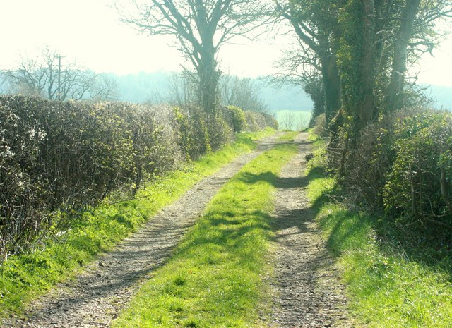
Photos 2008 : Track on Holts Down
‹ ›
Weather for this location Next 14 days Nearby places Useful places within 5 km
All Historic
Own or manage this place?
Claim this listing to keep details accurate, add photos, and highlight what makes it special — free.
Claim this page→ How useful was the information on this page?
id: bb761d18-6ce7-489b-a1d4-6321db96b24b
UK green spaces mapped from open public data — so anyone can find the woodland, trail, or nature reserve closest to them.
© 2026 Glade · Made with care for UK green spaces
Wildlife to spot
25,987 records · National Biodiversity Network
▾
Wildlife to spot 25,987 records · National Biodiversity Network Robin · Blackbird · Blue Tit · Carrion Crow · Woodpigeon +36
Robin Erithacus rubecula2025 Blackbird Turdus merula2025 Blue Tit Cyanistes caeruleus2025 Carrion Crow Corvus corone2025 Woodpigeon Columba palumbus2025 Great Tit Parus major2025 Goldfinch Carduelis carduelis2025 Kestrel Falco tinnunculus2025 Wren Troglodytes troglodytes2025 Magpie Pica pica2025 Canada Goose Branta canadensis Jackdaw Coloeus monedula2025 Skylark Alauda arvensis2025 Swallow Hirundo rustica2025 Mandarin Duck Aix galericulata2025 Starling Sturnus vulgaris2025 Pheasant Phasianus colchicus2025 Golden Plover Pluvialis apricaria2025 Rook Corvus frugilegus2025 Redwing Turdus iliacus2025 Chiffchaff Phylloscopus collybita2025 Long-tailed Tit Aegithalos caudatus2025 Goldcrest Regulus regulus2025 Great Spotted Woodpecker Dendrocopos major2025 Blackcap Sylvia atricapilla2025 Dunnock Prunella modularis2025 Grey Heron Ardea cinerea2025 Mallard Anas platyrhynchos2025 Herring Gull Larus argentatus2025 Fieldfare Turdus pilaris2025 Jay Garrulus glandarius2025 Pied Wagtail Motacilla alba2025 Raven Corvus corax2025 Linnet Linaria cannabina2025 Chaffinch Fringilla coelebs2025 Yellowhammer Emberiza citrinella2025 Siskin Spinus spinus2025 Meadow Pipit Anthus pratensis2025 House Martin Delichon urbicum2025 Cormorant Phalacrocorax carbo2025 Kingfisher Alcedo atthis2025 Mesembrina meridiana · Eristalis tenax · Aphrophora alni · Broad-bodied Chaser · Myrmica sabuleti +37
Mesembrina meridiana Mesembrina meridiana2024 Eristalis tenax Eristalis tenax2024 Aphrophora alni Aphrophora alni Broad-bodied Chaser Libellula depressa Myrmica sabuleti Myrmica sabuleti2024 Calathus fuscipes Calathus fuscipes Common Nettle · Dittander · Rambling Tail-moss · Bramble · Cleavers +22
Common Nettle Urtica dioica Dittander Lepidium latifolium Rambling Tail-moss Anomodon viticulosus Bramble Rubus fruticosus Cleavers Galium aparine Hogweed Heracleum sphondylium Lords-and-Ladies Arum maculatum Species observations from the last 10 years via NBN Atlas
2024
2024
Carabus problematicus Carabus problematicus2024
Carabus problematicus Carabus problematicus2024
Myrmica scabrinodis Myrmica scabrinodis2024
Myrmica scabrinodis Myrmica scabrinodis2024
Rhodaphodius foetens Rhodaphodius foetens2024
Rhodaphodius foetens Rhodaphodius foetens2024
Large White Pieris brassicae2024
Large White Pieris brassicae2024
Cuckoo-Spit Insect Philaenus spumarius2024
Cuckoo-Spit Insect Philaenus spumarius2024
Platycheirus clypeatus agg. Platycheirus clypeatus agg.
Platycheirus clypeatus agg. Platycheirus clypeatus agg.
Glow-worm Lampyris noctiluca
Glow-worm Lampyris noctiluca
Hawthorn Shieldbug Acanthosoma haemorrhoidale
Hawthorn Shieldbug Acanthosoma haemorrhoidale
Iris Weevil Mononychus punctumalbum
Iris Weevil Mononychus punctumalbum
Red-headed Cardinal Beetle Pyrochroa serraticornis
Red-headed Cardinal Beetle Pyrochroa serraticornis
Scathophaga stercoraria Scathophaga stercoraria2024
Scathophaga stercoraria Scathophaga stercoraria2024
Dock Bug Coreus marginatus2024
Dock Bug Coreus marginatus2024
Twin-spot Centurion Sargus bipunctatus2024
Twin-spot Centurion Sargus bipunctatus2024
Phaonia signata Phaonia signata2024
Phaonia signata Phaonia signata2024
Neomyia cornicina Neomyia cornicina2024
Neomyia cornicina Neomyia cornicina2024
Nimbus contaminatus Nimbus contaminatus2024
Nimbus contaminatus Nimbus contaminatus2024
Melinopterus prodromus Melinopterus prodromus2024
Melinopterus prodromus Melinopterus prodromus2024
Deer Ked Lipoptena cervi2024
Deer Ked Lipoptena cervi2024
Polietes lardarius Polietes lardarius2024
Polietes lardarius Polietes lardarius2024
Lasius alienus Lasius alienus2024
Lasius alienus Lasius alienus2024
Small Black Ant Lasius niger2024
Small Black Ant Lasius niger2024
Poecilus versicolor Poecilus versicolor2024
Poecilus versicolor Poecilus versicolor2024
Yellow Meadow Ant Lasius flavus2024
Yellow Meadow Ant Lasius flavus2024
Black Clock Pterostichus madidus2024
Black Clock Pterostichus madidus2024
Meadow Brown Maniola jurtina2024
Meadow Brown Maniola jurtina2024
Speckled Wood Pararge aegeria2024
Speckled Wood Pararge aegeria2024
Sarcophaga carnaria Sarcophaga carnaria2024
Sarcophaga carnaria Sarcophaga carnaria2024
Kite-tailed Robberfly Machimus atricapillus2024
Kite-tailed Robberfly Machimus atricapillus2024
Euscelis incisus Euscelis incisus2024
Euscelis incisus Euscelis incisus2024
Opomyza germinationis Opomyza germinationis2024
Opomyza germinationis Opomyza germinationis2024
Eupeodes latifasciatus Eupeodes latifasciatus2024
Eupeodes latifasciatus Eupeodes latifasciatus2024
Cortinicara gibbosa Cortinicara gibbosa2024
Cortinicara gibbosa Cortinicara gibbosa2024
Grass Ant Myrmecina graminicola2024
Grass Ant Myrmecina graminicola2024
Stictopleurus abutilon Stictopleurus abutilon2024
Stictopleurus abutilon Stictopleurus abutilon2024
Pea-leaf Weevil Sitona lineatus2024
Pea-leaf Weevil Sitona lineatus2024
Mecinus pyraster Mecinus pyraster2024
Mecinus pyraster Mecinus pyraster2024
Hart's-Tongue Asplenium scolopendrium
Hart's-Tongue Asplenium scolopendrium
Cow Parsley Anthriscus sylvestris
Cow Parsley Anthriscus sylvestris
Ground-ivy Glechoma hederacea
Ground-ivy Glechoma hederacea
Hawthorn Crataegus monogyna
Hawthorn Crataegus monogyna
Wood Avens Geum urbanum
Wood Avens Geum urbanum
Blackthorn Prunus spinosa
Blackthorn Prunus spinosa
Ivy Hedera helix
Ivy Hedera helix
Ragged-Robin Silene flos-cuculi
Ragged-Robin Silene flos-cuculi
Common Twayblade Neottia ovata
Common Twayblade Neottia ovata
Common Spotted-orchid Dactylorhiza fuchsii
Common Spotted-orchid Dactylorhiza fuchsii
Yellow Iris Iris pseudacorus
Yellow Iris Iris pseudacorus
Bluebell Hyacinthoides non-scripta
Bluebell Hyacinthoides non-scripta
Dog's Mercury Mercurialis perennis
Dog's Mercury Mercurialis perennis
Bugle Ajuga reptans
Bugle Ajuga reptans
Lamiastrum galeobdolon subsp. montanum Lamiastrum galeobdolon subsp. montanum
Lamiastrum galeobdolon subsp. montanum Lamiastrum galeobdolon subsp. montanum
Fool's Water-Cress Helosciadium nodiflorum
Fool's Water-Cress Helosciadium nodiflorum
Cuckooflower Cardamine pratensis
Cuckooflower Cardamine pratensis
Red Dead-nettle Lamium purpureum2024
Red Dead-nettle Lamium purpureum2024
Cowslip Primula veris2024
Cowslip Primula veris2024
Wall Scalewort Porella platyphylla2024
Wall Scalewort Porella platyphylla2024 Events & activities nearby Switch provider to compare local events, tours and bookable activities.
Bookable tours GetYourGuide Promote here