Peveril Castle eleventh to fourteenth century tower keep castle
2 ha
Plan your visit
🦅Birds✦Heritage🦉Wildlife
Public accessFree entryDogs welcome2 ha
Getting here
53.34054, -1.77733
Open directionsv
Visiting this summer
Seasonal nature notes and what to look for now
- 🐦58+ species recorded in this area — summer evenings are best for activity; watch for Jackdaw and Carrion Crow
- ✦Historic character is a year-round quality here — summer brings its own atmosphere to the setting
- ☕Dollys Tearooms — makes this an easy full-day family visit without needing to pack food
🌤️ Visiting this summer
- 🐦58+ species recorded in this area — summer evenings are best for activity; watch for Jackdaw and Carrion Crow
- ✦Historic character is a year-round quality here — summer brings its own atmosphere to the setting
- ☕Dollys Tearooms — makes this an easy full-day family visit without needing to pack food
- £Free to visit — no entry charge
- 🐕Dogs welcome
🦅Bird watching
Very strong match
Birds — Jackdaw, Carrion Crow, Robin +55 more · last seen 2026; Deciduous woodland — woodpeckers, warblers and woodland birds
Free
✦Heritage
Very strong match
Grade I listed building: PEVERIL CASTLE CURTAIN WALLS AND FRAGMENTARY FOUNDATIONS; Historic site with public access
Free
Birds — Jackdaw, Carrion Crow, Robin +55 more · last seen 2026; Deciduous woodland priority habitat
Free
🦋Insect spotting
Strong match
Insects — 7-spot Ladybird, Hairy Shieldbug, Slender Ant +66 more · last seen 2026; Acid grassland — heathland butterflies and rare invertebrates
Free
🍂Seasonal nature
Strong match
Plants — Common Bird's-foot-trefoil, Harebell, Wild Marjoram +179 more · last seen 2026
Free
🛝Family friendly
Good match
café
Free
Trails nearby
Within roughly 5 km10 signed routes nearby · 22 public paths nearby
Signed route nearbyPublic paths
Limestone WayWalking route74 km▾
Castleton to Rocester
Named routeLength 74 kmPoint-to-pointRegional walking route
Derwent Valley Heritage WayWalking route89 km▾
Named routeLength 89 kmRegional walking route
Edale Circular Walk, High PeakWalking route5.4 km▾
Low level circular walk which includes part of the Pennine Way, following streams and stone-flagged paths. Dogs must be kept on leads.
Named routeLength 5.4 kmDuration 02:00Round tripLocal walking route
Crook Hill Circular (Ethel), High PeakWalking route11.5 km▾
Named routeLength 11.5 kmDuration 03:30Round tripLocal walking route
Peak District Boundary Walk Stage 2Walking route15.6 km▾
Named routeLength 15.6 kmRegional walking route
Dirty Lanepublic footpath · 44 m▾
Public pathpublic footpathLength 44 mSurface gravelPath type: track
Dirty Lanepublic footpath · 7 m▾
Public pathpublic footpathLength 7 mSurface asphaltPath type: service
Mill Lanepublic footpath · 110 m▾
Public pathpublic footpathLength 110 mSurface fine_gravelPath type: track
13 signed routes nearby
Signed route nearby
Thornhill TrailCycling route▾
Named routeLocal cycle route
Route 6Cycling route▾
Named routeRef 6National Cycle Network
Main RouteCycling route454 m▾
Named routeRef 6Length 454 mNational Cycle NetworkOn-roadSurface asphalt
Main RouteCycling route119 m▾
Named routeRef 6Length 119 mNational Cycle NetworkOn-roadSurface asphalt
Main RouteCycling route252 m▾
Named routeRef 6Length 252 mNational Cycle NetworkTraffic-freeSurface asphalt
Main RouteCycling route347 m▾
Named routeRef 6Length 347 mNational Cycle NetworkTraffic-freeSurface unsealedfirm
1 signed route nearby
Signed route nearby
Great North Trail (Peak District and South Pennines)Mountain bike route130.4 km▾
Named routeLength 130.4 kmNational Cycle Network
3 public paths nearby
Public paths
Cave Dalebridleway · 49 m▾
Public pathbridlewayLength 49 mSurface asphaltPath type: bridleway
Cave Dalebridleway · 579 m▾
Public pathbridlewayLength 579 mSurface rockIncline steepPath type: bridleway
Photos
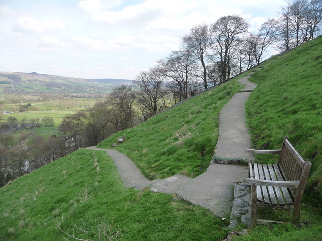
Castleton: path to Peveril Castle
Weather for this location
Next 14 daysNearby places
Useful places within 5 km
Events & activities nearby
Switch provider to compare local events, tours and bookable activities.
Wildlife to spot
10,296 records · National Biodiversity Network
Wildlife to spot
10,296 records · National Biodiversity Network🐦Birds36 species
summerautumn
2026▾
Jackdaw · Chaffinch · Carrion Crow · Wren · Swallow +31
- JackdawColoeus monedula2025
- ChaffinchFringilla coelebs
- Carrion CrowCorvus corone2025
- WrenTroglodytes troglodytes2025
- SwallowHirundo rustica2025
- RookCorvus frugilegus2025
- GoldcrestRegulus regulus2025
- RobinErithacus rubecula2025
- MagpiePica pica2025
- ChiffchaffPhylloscopus collybita2025
- Blue TitCyanistes caeruleus2025
- MallardAnas platyrhynchos2025
- NuthatchSitta europaea2025
- WoodpigeonColumba palumbus2025
- BlackbirdTurdus merula2025
- Golden PloverPluvialis apricaria2025
- Coal TitPeriparus ater2025
- TreecreeperCerthia familiaris2025
- DunnockPrunella modularis2025
- Collared DoveStreptopelia decaocto
- StarlingSturnus vulgaris2025
- FieldfareTurdus pilaris2025
- LinnetLinaria cannabina2025
- Lesser Black-backed GullLarus fuscus2025
- Long-tailed TitAegithalos caudatus2025
- CormorantPhalacrocorax carbo2025
- Pied WagtailMotacilla alba yarrellii2025
- WheatearOenanthe oenanthe2025
- Stock DoveColumba oenas2025
- KestrelFalco tinnunculus2025
- House MartinDelichon urbicum2025
- MoorhenGallinula chloropus2025
- Grey WagtailMotacilla cinerea2025
- PheasantPhasianus colchicus2025
- GoldfinchCarduelis carduelis2025
- Meadow PipitAnthus pratensis2025
Common Lizard
- Common LizardZootoca vivipara
🐸Amphibians2 species
spring
2026▾
Common Frog · Common Toad
- Common FrogRana temporaria
- Common ToadBufo bufo
Hairy Shieldbug · 7-spot Ladybird · Herina nigrina · Brachypera zoilus · Mecinus pyraster +20
- Hairy ShieldbugDolycoris baccarum2025
- 7-spot LadybirdCoccinella septempunctata
- Herina nigrinaHerina nigrina2025
- Brachypera zoilusBrachypera zoilus
- Mecinus pyrasterMecinus pyraster
- Back-SwimmerNotonecta
Meadow Vetchling · Common Bird's-foot-trefoil · Harebell · Wild Strawberry · Lesser Celandine +53
- Meadow VetchlingLathyrus pratensis2025
- Common Bird's-foot-trefoilLotus corniculatus2025
- HarebellCampanula rotundifolia2025
- Wild StrawberryFragaria vesca2025
- Lesser CelandineFicaria verna
- Tufted VetchVicia cracca
Species observations from the last 10 years via NBN Atlas
Elaphrus cupreus
Elaphrus cupreus
Elaphrus cupreus
Elaphrus cupreus
Dull Four-spined LegionnaireChorisops tibialis2025Dull Four-spined LegionnaireChorisops tibialis2025Herina lugubrisHerina lugubris2025Herina lugubrisHerina lugubris2025Sciara hemerobioidesSciara hemerobioides2025Sciara hemerobioidesSciara hemerobioides2025Tipula fulvipennisTipula fulvipennis2025Tipula fulvipennisTipula fulvipennis2025Tipula paludosaTipula paludosa2025Tipula paludosaTipula paludosa2025Limonia nubeculosaLimonia nubeculosa2025Limonia nubeculosaLimonia nubeculosa2025Rhopalus (Rhopalus) subrufusRhopalus (Rhopalus) subrufus2025Rhopalus (Rhopalus) subrufusRhopalus (Rhopalus) subrufus2025Syritta pipiensSyritta pipiens2025Syritta pipiensSyritta pipiens2025Red-legged ShieldbugPentatoma rufipes2025Red-legged ShieldbugPentatoma rufipes2025Green ShieldbugPalomena prasina2025Green ShieldbugPalomena prasina2025Ant Damsel BugHimacerus (Aptus) mirmicoides2025Ant Damsel BugHimacerus (Aptus) mirmicoides2025Sicus ferrugineusSicus ferrugineus2025Sicus ferrugineusSicus ferrugineus2025Eriozona syrphoidesEriozona syrphoides2025Eriozona syrphoidesEriozona syrphoides2025Yellow Meadow AntLasius flavus2025Yellow Meadow AntLasius flavus2025Tree HopperCentrotus cornutus2025Tree HopperCentrotus cornutus2025Hornet HoverflyVolucella zonaria2025Hornet HoverflyVolucella zonaria2025Small Black AntLasius niger2025Small Black AntLasius niger2025Sphaerophoria scriptaSphaerophoria scripta2025Sphaerophoria scriptaSphaerophoria scripta20252025
2025
Common ValerianValeriana officinalis2025Common ValerianValeriana officinalis2025ColtsfootTussilago farfara2025ColtsfootTussilago farfara2025Small ScabiousScabiosa columbaria2025Small ScabiousScabiosa columbaria2025Meadow ButtercupRanunculus acris2025Meadow ButtercupRanunculus acris2025Common Spotted-orchidDactylorhiza fuchsii2025Common Spotted-orchidDactylorhiza fuchsii2025EyebrightEuphrasia2025EyebrightEuphrasia2025Wild MarjoramOriganum vulgare2025Wild MarjoramOriganum vulgare2025Glaucous SedgeCarex flacca2025Glaucous SedgeCarex flacca2025Maidenhair SpleenwortAsplenium trichomanesMaidenhair SpleenwortAsplenium trichomanesBarren StrawberryPotentilla sterilisBarren StrawberryPotentilla sterilisCrested Dog's-tailCynosurus cristatus2025Crested Dog's-tailCynosurus cristatus2025Green SpleenwortAsplenium viride2025Green SpleenwortAsplenium viride2025Opposite-leaved Golden-saxifrageChrysosplenium oppositifolium2025Opposite-leaved Golden-saxifrageChrysosplenium oppositifolium2025Wood-sorrelOxalis acetosella2025Wood-sorrelOxalis acetosella2025CrosswortCruciata laevipes2025CrosswortCruciata laevipes2025Annual Meadow-grassPoa annua2025Annual Meadow-grassPoa annua2025Dame's-violetHesperis matronalis2025Dame's-violetHesperis matronalis2025Mouse-ear-hawkweedPilosella officinarum2025Mouse-ear-hawkweedPilosella officinarum2025Spring SandwortSabulina verna2025Spring SandwortSabulina verna2025Western GorseUlex gallii2025Western GorseUlex gallii2025Hemp-agrimonyEupatorium cannabinum2025Hemp-agrimonyEupatorium cannabinum2025Meadow Crane's-billGeranium pratense2025Meadow Crane's-billGeranium pratense2025Water HorsetailEquisetum fluviatile2025Water HorsetailEquisetum fluviatile2025Ground-elderAegopodium podagraria2025Ground-elderAegopodium podagraria2025Soft-rushJuncus effusus2025Soft-rushJuncus effusus2025Common Fragrant-orchidGymnadenia conopsea2025Common Fragrant-orchidGymnadenia conopsea2025Quaking-grassBriza media2025Quaking-grassBriza media2025IvyHedera helix2025IvyHedera helix2025Lady's BedstrawGalium verum2025Lady's BedstrawGalium verum2025Common KnapweedCentaurea nigra2025Common KnapweedCentaurea nigra2025Ribwort PlantainPlantago lanceolata2025Ribwort PlantainPlantago lanceolata2025Rough HawkbitLeontodon hispidus2025Rough HawkbitLeontodon hispidus2025BeechFagus sylvatica2025BeechFagus sylvatica2025BulrushTypha latifolia2025BulrushTypha latifolia2025Grey AlderAlnus incana2025Grey AlderAlnus incana2025St. John's-WortHypericum2025St. John's-WortHypericum2025CuckooflowerCardamine pratensis2025CuckooflowerCardamine pratensis2025MeadowsweetFilipendula ulmaria2025MeadowsweetFilipendula ulmaria2025BrambleRubus fruticosus2025BrambleRubus fruticosus2025Common Spike-rushEleocharis palustris2025Common Spike-rushEleocharis palustris2025Lords-and-LadiesArum maculatum2025Lords-and-LadiesArum maculatum2025Great WillowherbEpilobium hirsutum2025Great WillowherbEpilobium hirsutum2025SedumSedum2025SedumSedum2025Common TwaybladeNeottia ovata2025Common TwaybladeNeottia ovata2025SycamoreAcer pseudoplatanus2025SycamoreAcer pseudoplatanus2025Brittle Bladder-fernCystopteris fragilis2025Brittle Bladder-fernCystopteris fragilis2025Wood SageTeucrium scorodonia2025Wood SageTeucrium scorodonia2025Sweet Vernal-grassAnthoxanthum odoratum2025Sweet Vernal-grassAnthoxanthum odoratum2025Burnet-saxifragePimpinella saxifraga2025Burnet-saxifragePimpinella saxifraga2025Jointed RushJuncus articulatus2025Jointed RushJuncus articulatus2025Gymnadenia conopseaGymnadenia conopsea2025Gymnadenia conopseaGymnadenia conopsea2025AshFraxinus excelsior2025AshFraxinus excelsior2025