Plan your visit
🦅 Birds🧺 Picnic✦ Heritage
Public access Free entry Dogs welcome 0 ha
Getting here
54.77093, -1.57946
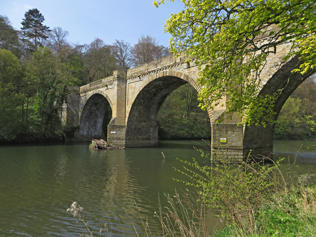
Open directionsv Prebends Bridge, along with Framwellgate and Elvet bridges, is one of three stone-arch bridges in the centre of Durham, England, that cross the River Wear. The bridge forms part of the Durham Castle and Cathedral UNESCO World Heritage Site.
Read more on Wikipedia → Bridge scheduled monument c. 1772
Visiting this summer
Seasonal nature notes and what to look for now
▾ 🐦 49+ species recorded in this area — summer evenings are best for activity; watch for Woodpigeon and Magpie 🧺 Good picnic destination in summer — open space and facilities for a relaxed day out ☕ Undercroft restaurant — makes this an easy full-day family visit without needing to pack food 🌤️ Visiting this summer
🐦 49+ species recorded in this area — summer evenings are best for activity; watch for Woodpigeon and Magpie 🧺 Good picnic destination in summer — open space and facilities for a relaxed day out ☕ Undercroft restaurant — makes this an easy full-day family visit without needing to pack food £ Free to visit — no entry charge🐕 Dogs welcome☕ Café🅿️ Parking· Paid 🧺 Picnic spot🚻 Toilets
🦅 Bird watching
Very strong match
Birds — Woodpigeon, Magpie, Moorhen +46 more · last seen 2026; Deciduous woodland — woodpeckers, warblers and woodland birds
Free
🧺 Picnic day out
Very strong match
picnic area, café, toilets, car park
Free
✦ Heritage
Very strong match
Grade I listed building: PREBENDS BRIDGE; Historic site with public access
Free
Mammals — Rabbit, Grey Squirrel, Red Fox +11 more · last seen 2025; Deciduous woodland priority habitat
Free
🛝 Family friendly
Strong match
café, toilets, picnic area
Free
🍂 Seasonal nature
Strong match
Plants — Garlic Mustard, Snowdrop, Ivy +49 more · last seen 2026
Free
Trails nearby Within roughly 5 km 23 signed routes nearby · 73 public paths nearby
Signed route nearby Public paths
Weardale Way Walking route 124 km ▾
Named route Length 124 km Regional walking route
Show on map Small Pilgrim Places Walking route 14.5 km ▾
Named route Length 14.5 km Round trip Local walking route
Show on map Cassop-cum-Quarrington circular walk Walking route ▾
Named route Local walking route
Show on map Jubilee Walk Walking route ▾
Named route Round trip Local walking route
Show on map Houghall Discovery Trail Walking route ▾
Named route Round trip Local walking route
Show on map Clay Lane public footpath · 130 m ▾
Public path public footpath Length 130 m Surface asphalt Path type: service
Show on map School Lane public footpath · 135 m ▾
Public path public footpath Length 135 m Surface dirt Path type: footway
Show on map Windy Gap public footpath · 52 m ▾
Public path public footpath Length 52 m Surface paving_stones Path type: footway
Show on map 66 signed routes nearby
Signed route nearby
Walney to Wear Cycle Route Cycling route ▾
Named route Ref 70 National Cycle Network
Show on map Route 14 Cycling route ▾
Named route Ref 14 National Cycle Network
Show on map Great North Cycleway Cycling route ▾
Named route Ref 725 National Cycle Network
Show on map Great North Cycleway Cycling route ▾
Named route Ref 725 National Cycle Network
Show on map Langley Park to Sniperly Link Cycling route ▾
Named route Local cycle route
Show on map National Byway (County Durham and Northumberland) Cycling route ▾
The National Byway route through County Durham and Northumberland
Named route Ref NB Regional cycle route
Show on map
Weather for this location Next 14 days Nearby places Useful places within 5 km
All Historic
UK green spaces mapped from open public data — so anyone can find the woodland, trail, or nature reserve closest to them.
© 2026 Glade · Made with care for UK green spaces
Wildlife to spot
49,100 records · National Biodiversity Network
▾
Wildlife to spot 49,100 records · National Biodiversity Network 🐦 Birds 36 species
spring autumn winter
2026 ▾
Magpie · Long-tailed Tit · Robin · Blackbird · Nuthatch +31
Magpie Pica pica Long-tailed Tit Aegithalos caudatus Robin Erithacus rubecula Blackbird Turdus merula Nuthatch Sitta europaea Bullfinch Pyrrhula pyrrhula Great Tit Parus major Jay Garrulus glandarius Redwing Turdus iliacus Moorhen Gallinula chloropus Blue Tit Cyanistes caeruleus Wren Troglodytes troglodytes Chaffinch Fringilla coelebs Kingfisher Alcedo atthis Jackdaw Coloeus monedula Carrion Crow Corvus corone2025 Dunnock Prunella modularis Goldfinch Carduelis carduelis Treecreeper Certhia familiaris Goldcrest Regulus regulus Tawny Owl Strix aluco2025 Woodpigeon Columba palumbus2025 Woodcock Scolopax rusticola2025 Grey Heron Ardea cinerea Mallard Anas platyrhynchos Coal Tit Periparus ater Little Grebe Tachybaptus ruficollis Song Thrush Turdus philomelos2025 Stock Dove Columba oenas2025 Siskin Spinus spinus2025 Pheasant Phasianus colchicus2025 Black-headed Gull Chroicocephalus ridibundus2025 Herring Gull Larus argentatus2025 Pied Wagtail Motacilla alba2025 Cormorant Phalacrocorax carbo2025 Fieldfare Turdus pilaris2025 Otter · Stoat · Roe Deer · Grey Squirrel
Otter Lutra lutra Stoat Mustela erminea Roe Deer Capreolus capreolus Grey Squirrel Sciurus carolinensis 🐸 Amphibians 2 species
winter spring
2026 ▾
Common Frog · Common Toad
Common Frog Rana temporaria Common Toad Bufo bufo 7-spot Ladybird · Harlequin Ladybird · Carabus nemoralis · 10-spot Ladybird · Orange Ladybird +2
7-spot Ladybird Coccinella septempunctata Harlequin Ladybird Harmonia axyridis Carabus nemoralis Carabus nemoralis 10-spot Ladybird Adalia decempunctata Orange Ladybird Halyzia sedecimguttata Syrphus Syrphus2025 Larch Ladybird 🌿 Plants 49 species
winter spring
2026 ▾
Garlic Mustard · Snowdrop · Ivy · Daisy · Creeping Buttercup +44
Garlic Mustard Alliaria petiolata Snowdrop Galanthus nivalis Ivy Hedera helix Daisy Bellis perennis Creeping Buttercup Ranunculus repens Lesser Celandine Ficaria verna Herb-Robert Species observations from the last 10 years via NBN Atlas
Aphidecta obliterata2025
Aphidecta obliterata2025
Geranium robertianum
Geranium robertianum
Wood Avens Geum urbanum
Wood Avens Geum urbanum
Butterbur Petasites hybridus
Butterbur Petasites hybridus
Ramsons Allium ursinum
Ramsons Allium ursinum
Hart's-Tongue Asplenium scolopendrium
Hart's-Tongue Asplenium scolopendrium
Primrose Primula vulgaris
Primrose Primula vulgaris
Lords-and-Ladies Arum maculatum
Lords-and-Ladies Arum maculatum
Dove's-foot Crane's-bill Geranium molle
Dove's-foot Crane's-bill Geranium molle
Honesty Lunaria annua
Honesty Lunaria annua
Spear Thistle Cirsium vulgare
Spear Thistle Cirsium vulgare
Ribwort Plantain Plantago lanceolata
Ribwort Plantain Plantago lanceolata
Holly Ilex aquifolium
Holly Ilex aquifolium
Cleavers Galium aparine
Cleavers Galium aparine
Common Nettle Urtica dioica
Common Nettle Urtica dioica
Winter Aconite Eranthis hyemalis
Winter Aconite Eranthis hyemalis
Marsh-marigold Caltha palustris
Marsh-marigold Caltha palustris
Pineappleweed Matricaria discoidea
Pineappleweed Matricaria discoidea
Feverfew Tanacetum parthenium
Feverfew Tanacetum parthenium
Winter Heliotrope Petasites pyrenaicus
Winter Heliotrope Petasites pyrenaicus
Nipplewort Lapsana communis
Nipplewort Lapsana communis
Common Whitlowgrass Erophila verna
Common Whitlowgrass Erophila verna
Shepherd's-purse Capsella bursa-pastoris
Shepherd's-purse Capsella bursa-pastoris
Groundsel Senecio vulgaris
Groundsel Senecio vulgaris
Bramble Rubus fruticosus
Bramble Rubus fruticosus
Oxeye Daisy Leucanthemum vulgare
Oxeye Daisy Leucanthemum vulgare
False Oat-grass Arrhenatherum elatius
False Oat-grass Arrhenatherum elatius
Common Chickweed Stellaria media
Common Chickweed Stellaria media
Smooth Sow-thistle Sonchus oleraceus
Smooth Sow-thistle Sonchus oleraceus
Common Mouse-ear Cerastium fontanum
Common Mouse-ear Cerastium fontanum
Yarrow Achillea millefolium
Yarrow Achillea millefolium
Hairy Bitter-cress Cardamine hirsuta
Hairy Bitter-cress Cardamine hirsuta
Ivy-leaved Toadflax Cymbalaria muralis
Ivy-leaved Toadflax Cymbalaria muralis
Annual Meadow-grass Poa annua
Annual Meadow-grass Poa annua
Petty Spurge Euphorbia peplus
Petty Spurge Euphorbia peplus
Oxford Ragwort Senecio squalidus
Oxford Ragwort Senecio squalidus
Alder Alnus glutinosa
Alder Alnus glutinosa
Red Dead-nettle Lamium purpureum
Red Dead-nettle Lamium purpureum
White Dead-nettle Lamium album
White Dead-nettle Lamium album
Red Campion Silene dioica
Red Campion Silene dioica
Wavy Bitter-cress Cardamine flexuosa
Wavy Bitter-cress Cardamine flexuosa
Gorse Ulex europaeus
Gorse Ulex europaeus
Yew Taxus baccata2025
Yew Taxus baccata2025
Fig Ficus carica2025
Fig Ficus carica2025 Events & activities nearby Switch provider to compare local events, tours and bookable activities.
Bookable tours GetYourGuide Tripadvisor