Round cairn on Bridge-end Pasture, 600m north-east of Two Thorne Fields Farm 0 ha
🦉 Wildlife🦅 Birds🍂 Seasonal
↑ Share
Free entry Dogs welcome 0 ha
Places › England › East Midlands › High Peak Getting here
53.38625, -1.73617
Open directionsv ✦ Scheduled Ancient Monument — Nationally protected archaeological site on the National Heritage List for England (NHLE). Scheduled monuments represent the best surviving examples of England's irreplaceable archaeological heritage.
Round cairn scheduled monument
Visiting this summer
Seasonal nature notes and what to look for now
▾ 🌞 Midsummer — early morning visits most comfortable; look for deer fawns in quieter clearings ✦ Historic character is a year-round quality here — summer brings its own atmosphere to the setting 🐕 Dogs welcome — bring water in summer; the site has enough space to find shade on hot days 🌤️ Visiting this summer
🌞 Midsummer — early morning visits most comfortable; look for deer fawns in quieter clearings ✦ Historic character is a year-round quality here — summer brings its own atmosphere to the setting 🐕 Dogs welcome — bring water in summer; the site has enough space to find shade on hot days £ Free to visit — no entry charge🐕 Dogs welcome🦉 Wildlife
Very strong match
Multi-group wildlife — Amphibians, Birds, Mammals, Reptiles; Multi-group wildlife — Amphibians, Birds, Mammals, Reptiles
Free
🦅 Bird watching
Very strong match
Birds — Chaffinch, Robin, Mallard +73 more · last seen 2026; Birds — Chaffinch, Robin, Mallard +73 more · last seen 2026
Free
🍂 Seasonal nature
Strong match
Plants — Foxglove, Japanese Knotweed, Betony +38 more · last seen 2026; Plants — Foxglove, Japanese Knotweed, Betony +38 more · last seen 2026
Free
🦋 Insect spotting
Strong match
Insects — Hairy Wood Ant, Anoplotrupes stercorosus, Common Cockchafer +38 more · last seen 2026; Insects — Hairy Wood Ant, Anoplotrupes stercorosus, Common Cockchafer +38 more · last seen 2026
Free
Plants — Wood-sorrel, Barren Strawberry, Mouse-ear-hawkweed +4 more foraging species
Varies
Trails nearby Within roughly 5 km 13 signed routes nearby
Signed route nearby
Limestone Way Walking route 74 km ▾
Castleton to Rocester
Named route Length 74 km Point-to-point Regional walking route
Show on map Derwent Valley Heritage Way Walking route 89 km ▾
Named route Length 89 km Regional walking route
Show on map Derwent Valley and Reservoir Walk, Walking route 7.4 km ▾
Ladybower Reservoir, farmland and wooded cloughs. Views of Derwent Valley and High Peak area. Rough walking through fields, woodland paths, roads and open moorland. Dogs must be on leads.
Named route Length 7.4 km Duration 02:30 Round trip Local walking route
Show on map Crook Hill Circular (Ethel), High Peak Walking route 11.5 km ▾
Named route Length 11.5 km Duration 03:30 Round trip Local walking route
Show on map Lost Lad and Back Tor (Ethels), High Peak Walking route 12.1 km ▾
Named route Length 12.1 km Duration 04:00 Round trip Local walking route
Show on map 15 signed routes nearby
Signed route nearby
Thornhill Trail Cycling route ▾
Named route Local cycle route
Show on map Route 6 Cycling route ▾
Named route Ref 6 National Cycle Network
Show on map Main Route Cycling route 454 m ▾
Named route Ref 6 Length 454 m National Cycle Network On-road Surface asphalt
Show on map Main Route Cycling route 119 m ▾
Named route Ref 6 Length 119 m National Cycle Network On-road Surface asphalt
Show on map Main Route Cycling route 252 m ▾
Named route Ref 6 Length 252 m National Cycle Network Traffic-free Surface asphalt
Show on map Main Route Cycling route 347 m ▾
Named route Ref 6 Length 347 m National Cycle Network Traffic-free Surface unsealedfirm
Show on map 1 signed route nearby
Signed route nearby
Great North Trail (Peak District and South Pennines) Mountain bike route 130.4 km ▾
Named route Length 130.4 km National Cycle Network
Show on map 5 public paths nearby
Public paths
No named routes yet. Public paths are shown on the map.
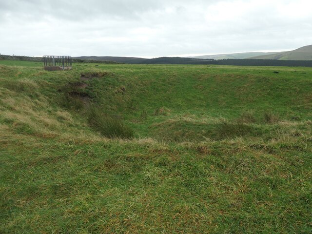
Photos The larger of two small pits, Bridge-end Pasture
‹ ›
Weather for this location Next 14 days Nearby places Useful places within 5 km
All Historic
Own or manage this place?
Claim this listing to keep details accurate, add photos, and highlight what makes it special — free.
Claim this page→ How useful was the information on this page?
Something wrong on this page?
id: ce1d346f-7c99-4257-9ae8-a31cb5908e88
UK green spaces mapped from open public data — so anyone can find the woodland, trail, or nature reserve closest to them.
© 2026 Glade · Made with care for UK green spaces
Events & activities nearby Switch provider to compare local events, tours and bookable activities.
Bookable tours GetYourGuide Promote here
Wildlife to spot
10,062 records · National Biodiversity Network
▾
Wildlife to spot 10,062 records · National Biodiversity Network Kestrel · Robin · Mallard · Blackbird · Jackdaw +20
Kestrel Falco tinnunculus Robin Erithacus rubecula Mallard Anas platyrhynchos Blackbird Turdus merula2025 Jackdaw Coloeus monedula2025 Goldcrest Regulus regulus2025 Great Tit Parus major2025 Redwing Turdus iliacus2025 Mistle Thrush Turdus viscivorus2025 Long-tailed Tit Aegithalos caudatus2025 Grey Heron Ardea cinerea2025 Coal Tit Periparus ater2025 Greylag Goose Anser anser2025 Woodpigeon Columba palumbus2025 Dunnock Prunella modularis2025 Nuthatch Sitta europaea2025 Canada Goose Branta canadensis2025 Rook Corvus frugilegus2025 Carrion Crow Corvus corone2025 Wren Troglodytes troglodytes2025 Chaffinch Fringilla coelebs2025 Mandarin Duck Aix galericulata2025 Blue Tit Cyanistes caeruleus2025 Cormorant Phalacrocorax carbo2025 Fieldfare Turdus pilaris2025 Brown Hare · Grey Squirrel
Brown Hare Lepus europaeus Grey Squirrel Sciurus carolinensis Common Lizard
Common Lizard Zootoca vivipara 🐝 Insects 10 species
winter spring
2026 ▾
Hairy Wood Ant · Larch Ladybird · 10-spot Ladybird · Orange Ladybird · Poecilus versicolor +5
Hairy Wood Ant Formica lugubris Larch Ladybird Aphidecta obliterata 10-spot Ladybird Adalia decempunctata Orange Ladybird Halyzia sedecimguttata Poecilus versicolor Poecilus versicolor Cheilosia albipila Cheilosia albipila Japanese Larch · Foxglove · Autumn Hawkbit · Lady-fern · Bracken +108
Japanese Larch Larix kaempferi Foxglove Digitalis purpurea Autumn Hawkbit Scorzoneroides autumnalis2025 Lady-fern Athyrium filix-femina2025 Bracken Pteridium aquilinum2025 Tutsan Hypericum androsaemum2025 Species observations from the last 10 years via NBN Atlas
Helina evecta Helina evecta
Helina evecta Helina evecta
Bembidion properans Bembidion properans
Bembidion properans Bembidion properans
Drymus (Sylvadrymus) sylvaticus Drymus (Sylvadrymus) sylvaticus
Drymus (Sylvadrymus) sylvaticus Drymus (Sylvadrymus) sylvaticus
Dicyphus (Idolocoris) pallicornis Dicyphus (Idolocoris) pallicornis
Dicyphus (Idolocoris) pallicornis Dicyphus (Idolocoris) pallicornis
Bog Stitchwort Stellaria alsine2025
Bog Stitchwort Stellaria alsine2025
Coltsfoot Tussilago farfara2025
Coltsfoot Tussilago farfara2025
Male-fern Dryopteris filix-mas2025
Male-fern Dryopteris filix-mas2025
Ribwort Plantain Plantago lanceolata2025
Ribwort Plantain Plantago lanceolata2025
Greater Plantain Plantago major2025
Greater Plantain Plantago major2025
Bluebell Hyacinthoides non-scripta2025
Bluebell Hyacinthoides non-scripta2025
Dryopteris affinis Dryopteris affinis2025
Dryopteris affinis Dryopteris affinis2025
Broad-leaved Dock Rumex obtusifolius2025
Broad-leaved Dock Rumex obtusifolius2025
Broad Buckler-fern Dryopteris dilatata2025
Broad Buckler-fern Dryopteris dilatata2025
Creeping Thistle Cirsium arvense2025
Creeping Thistle Cirsium arvense2025
Opposite-leaved Golden-saxifrage Chrysosplenium oppositifolium2025
Opposite-leaved Golden-saxifrage Chrysosplenium oppositifolium2025
Bulbous Rush Juncus bulbosus2025
Bulbous Rush Juncus bulbosus2025
Common Dog-violet Viola riviniana2025
Common Dog-violet Viola riviniana2025
Spear Thistle Cirsium vulgare2025
Spear Thistle Cirsium vulgare2025
Meadow Buttercup Ranunculus acris2025
Meadow Buttercup Ranunculus acris2025
Broad-leaved Willowherb Epilobium montanum2025
Broad-leaved Willowherb Epilobium montanum2025
Daisy Bellis perennis2025
Daisy Bellis perennis2025
Beech Fagus sylvatica2025
Beech Fagus sylvatica2025
Common Mouse-ear Cerastium fontanum2025
Common Mouse-ear Cerastium fontanum2025
Hazel Corylus avellana2025
Hazel Corylus avellana2025
Mouse-ear-hawkweed Pilosella officinarum2025
Mouse-ear-hawkweed Pilosella officinarum2025
Yarrow Achillea millefolium2025
Yarrow Achillea millefolium2025
Barren Strawberry Potentilla sterilis2025
Barren Strawberry Potentilla sterilis2025
Bush Vetch Vicia sepium2025
Bush Vetch Vicia sepium2025
Silver Birch Betula pendula2025
Silver Birch Betula pendula2025
Curled Dock Rumex crispus2025
Curled Dock Rumex crispus2025
Winter-cress Barbarea vulgaris2025
Winter-cress Barbarea vulgaris2025
Common Mallow Malva sylvestris2025
Common Mallow Malva sylvestris2025
Rowan Sorbus aucuparia2025
Rowan Sorbus aucuparia2025
Selfheal Prunella vulgaris2025
Selfheal Prunella vulgaris2025
Soft-rush Juncus effusus2025
Soft-rush Juncus effusus2025
Water-Starwort Callitriche2025
Water-Starwort Callitriche2025
Garlic Mustard Alliaria petiolata2025
Garlic Mustard Alliaria petiolata2025
Hedera hibernica 'Hibernica' Hedera hibernica 'Hibernica'2025
Hedera hibernica 'Hibernica' Hedera hibernica 'Hibernica'2025
Shoreweed Littorella uniflora2025
Shoreweed Littorella uniflora2025
Short-fruited Willowherb Epilobium obscurum2025
Short-fruited Willowherb Epilobium obscurum2025
Annual Meadow-grass Poa annua2025
Annual Meadow-grass Poa annua2025
Canadian Fleabane Erigeron canadensis2025
Canadian Fleabane Erigeron canadensis2025
Yellow Pimpernel Lysimachia nemorum2025
Yellow Pimpernel Lysimachia nemorum2025
Sycamore Acer pseudoplatanus2025
Sycamore Acer pseudoplatanus2025
Smooth Sow-thistle Sonchus oleraceus2025
Smooth Sow-thistle Sonchus oleraceus2025
Smooth Meadow-grass Poa pratensis2025
Smooth Meadow-grass Poa pratensis2025
Lemon-scented Fern Oreopteris limbosperma2025
Lemon-scented Fern Oreopteris limbosperma2025
Ash Fraxinus excelsior2025
Ash Fraxinus excelsior2025
Large Bitter-cress Cardamine amara2025
Large Bitter-cress Cardamine amara2025
Tormentil Potentilla erecta2025
Tormentil Potentilla erecta2025
Marsh Thistle Cirsium palustre2025
Marsh Thistle Cirsium palustre2025
Common Chickweed Stellaria media2025
Common Chickweed Stellaria media2025
Lawson Cypress Cupressus lawsoniana2025
Lawson Cypress Cupressus lawsoniana2025
Downy Birch Betula pubescens2025
Downy Birch Betula pubescens2025
Sessile Oak Quercus petraea2025
Sessile Oak Quercus petraea2025
Bugle Ajuga reptans2025
Bugle Ajuga reptans2025
Hybrid Larch Larix decidua x kaempferi = L. x marschlinsii2025
Hybrid Larch Larix decidua x kaempferi = L. x marschlinsii2025
Marsh Pennywort Hydrocotyle vulgaris2025
Marsh Pennywort Hydrocotyle vulgaris2025
Hedge Woundwort Stachys sylvatica2025
Hedge Woundwort Stachys sylvatica2025
Euphrasia officinalis Euphrasia officinalis2025
Euphrasia officinalis Euphrasia officinalis2025
Rosebay Willowherb Chamaenerion angustifolium2025
Rosebay Willowherb Chamaenerion angustifolium2025
Knotgrass Polygonum aviculare2025
Knotgrass Polygonum aviculare2025
Harebell Campanula rotundifolia2025
Harebell Campanula rotundifolia2025
Norway Maple Acer platanoides2025
Norway Maple Acer platanoides2025
Wild Cherry Prunus avium2025
Wild Cherry Prunus avium2025
Yellow Dodder Cuscuta campestris2025
Yellow Dodder Cuscuta campestris2025
Common Sorrel Rumex acetosa2025
Common Sorrel Rumex acetosa2025
Upright Hedge-parsley Torilis japonica2025
Upright Hedge-parsley Torilis japonica2025
Heath Rush Juncus squarrosus2025
Heath Rush Juncus squarrosus2025
Elder Sambucus nigra2025
Elder Sambucus nigra2025
Water-pepper Persicaria hydropiper2025
Water-pepper Persicaria hydropiper2025
Wood-sedge Carex sylvatica2025
Wood-sedge Carex sylvatica2025
Italian Alder Alnus cordata2025
Italian Alder Alnus cordata2025
Wavy Bitter-cress Cardamine flexuosa2025
Wavy Bitter-cress Cardamine flexuosa2025
Hawkweed Hieracium2025
Hawkweed Hieracium2025
Goat Willow Salix caprea2025
Goat Willow Salix caprea2025
Wood-sorrel Oxalis acetosella2025
Wood-sorrel Oxalis acetosella2025
Polypodium vulgare Polypodium vulgare2025
Polypodium vulgare Polypodium vulgare2025
Greater Stitchwort Stellaria holostea2025
Greater Stitchwort Stellaria holostea2025
Heath Bedstraw Galium saxatile2025
Heath Bedstraw Galium saxatile2025
Snowberry Symphoricarpos albus2025
Snowberry Symphoricarpos albus2025
Smooth-stalked Sedge Carex laevigata2025
Smooth-stalked Sedge Carex laevigata2025
White Clover Trifolium repens2025
White Clover Trifolium repens2025
Mugwort Artemisia vulgaris2025
Mugwort Artemisia vulgaris2025
Common Bird's-foot-trefoil Lotus corniculatus2025
Common Bird's-foot-trefoil Lotus corniculatus2025
Tufted Hair-grass Deschampsia cespitosa2025
Tufted Hair-grass Deschampsia cespitosa2025
Bramble Rubus fruticosus2025
Bramble Rubus fruticosus2025
Creeping Bent Agrostis stolonifera2025
Creeping Bent Agrostis stolonifera2025
Rosa canina Rosa canina2025
Rosa canina Rosa canina2025
Black Nightshade Solanum nigrum2025
Black Nightshade Solanum nigrum2025
Yorkshire-fog Holcus lanatus2025
Yorkshire-fog Holcus lanatus2025
Perennial Rye-grass Lolium perenne2025
Perennial Rye-grass Lolium perenne2025
Thyme-leaved Speedwell Veronica serpyllifolia2025
Thyme-leaved Speedwell Veronica serpyllifolia2025
Common Bent Agrostis capillaris2025
Common Bent Agrostis capillaris2025
Scots Pine Pinus sylvestris2025
Scots Pine Pinus sylvestris2025
Toad Rush Juncus bufonius2025
Toad Rush Juncus bufonius2025
Salix caprea x cinerea = S. x reichardtii Salix caprea x cinerea = S. x reichardtii2025
Salix caprea x cinerea = S. x reichardtii Salix caprea x cinerea = S. x reichardtii2025
Lesser Spearwort Ranunculus flammula2025
Lesser Spearwort Ranunculus flammula2025
Greater Bird's-foot-trefoil Lotus pedunculatus2025
Greater Bird's-foot-trefoil Lotus pedunculatus2025
New Zealand Pigmyweed Crassula helmsii2025
New Zealand Pigmyweed Crassula helmsii2025
Wood Forget-me-not Myosotis sylvatica2025
Wood Forget-me-not Myosotis sylvatica2025
Wood Dock Rumex sanguineus2025
Wood Dock Rumex sanguineus2025
Marsh Cudweed Gnaphalium uliginosum2025
Marsh Cudweed Gnaphalium uliginosum2025
Festuca rubra Festuca rubra2025
Festuca rubra Festuca rubra2025
Remote Sedge Carex remota2025
Remote Sedge Carex remota2025
Fairy Flax Linum catharticum2025
Fairy Flax Linum catharticum2025
Great Willowherb Epilobium hirsutum2025
Great Willowherb Epilobium hirsutum2025
Common Ragwort Jacobaea vulgaris2025
Common Ragwort Jacobaea vulgaris2025
Germander Speedwell Veronica chamaedrys2025
Germander Speedwell Veronica chamaedrys2025
Guelder-rose Viburnum opulus2025
Guelder-rose Viburnum opulus2025
Hairy Wood-rush Luzula pilosa2025
Hairy Wood-rush Luzula pilosa2025