Plan your visit
🦅Birds🎠Play🛝Family
Public accessFree entryDogs welcome
Getting here
54.64974, -1.74585
Open directionsv
Visiting this summer
Seasonal nature notes and what to look for now
- 🐦51+ species recorded in this area — summer evenings are best for activity; watch for Woodpigeon and Blackbird
- ☀️Summer family visits work well here — arrive early and plan for a longer stay
- 🛝Playground on site — built-in entertainment for younger visitors alongside the wider site
🌤️ Visiting this summer
- 🐦51+ species recorded in this area — summer evenings are best for activity; watch for Woodpigeon and Blackbird
- ☀️Summer family visits work well here — arrive early and plan for a longer stay
- 🛝Playground on site — built-in entertainment for younger visitors alongside the wider site
- £Free to visit — no entry charge
- 🐕Dogs welcome
🅿️Parking🛝Playground🚻Toilets
🦅Bird watching
Very strong match
Birds — Woodpigeon, Blackbird, Jackdaw +48 more · last seen 2025
Free
playground, toilets, parking
Free
🛝Family friendly
Strong match
playground, toilets
Free
Birds — Woodpigeon, Blackbird, Jackdaw +48 more · last seen 2025
Free
🍂Seasonal nature
Good match
Plants — Snowberry, Musk-mallow, Common Mallow +16 more · last seen 2025
Free
Dogs allowed with public access
Free
Trails nearby
Within roughly 5 km6 signed routes nearby · 2 public paths nearby
Signed route nearbyPublic paths
Weardale WayWalking route124 km▾
Named routeLength 124 kmRegional walking route
Witon-le-Wear Circular Walk 2Walking route▾
Named routeLocal walking route
Witton-le-Wear Circular Walk 1Walking route▾
Named routeLocal walking route
Finchale Camino Inglés (Durham to Escomb)Walking route▾
Named routePoint-to-pointRegional walking route
Mineral Valleys Walk - Escomb, Witton Park & EtherleyWalking route▾
Named routeRound tripLocal walking route
44 signed routes nearby
Signed route nearby
Walney to Wear Cycle RouteCycling route▾
Named routeRef 70National Cycle Network
National Cycle Network Route 715Cycling route▾
Walney to Wear (via Bishop Auckland)
Named routeRef 715National Cycle Network
National Byway (County Durham and Northumberland)Cycling route▾
The National Byway route through County Durham and Northumberland
Named routeRef NBRegional cycle route
Main RouteCycling route1.5 km▾
Named routeRef 715Length 1.5 kmNational Cycle NetworkTraffic-freeSurface unsealedfirm
Main RouteCycling route588 m▾
Named routeRef 70Length 588 mNational Cycle NetworkOn-roadSurface asphalt
Main RouteCycling route20 m▾
Named routeRef 70Length 20 mNational Cycle NetworkOn-roadSurface asphalt
2 public paths nearby
Public paths
No named routes yet. Public paths are shown on the map.
Photos
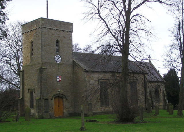
St.Cuthbert's Church : High Etherley
Weather for this location
Next 14 daysNearby places
Useful places within 5 km
Wildlife to spot
3,535 records · National Biodiversity Network
Wildlife to spot
3,535 records · National Biodiversity Network🐦Birds51 species
springsummer
2025▾
Woodpigeon · Blackbird · Jackdaw · Carrion Crow · Wren +46
- WoodpigeonColumba palumbus
- BlackbirdTurdus merula
- JackdawColoeus monedula
- Carrion CrowCorvus corone
- WrenTroglodytes troglodytes
- MagpiePica pica
- Blue TitCyanistes caeruleus
- ChaffinchFringilla coelebs
- RobinErithacus rubecula
- Great TitParus major
- StarlingSturnus vulgaris
- Coal TitPeriparus ater
- PheasantPhasianus colchicus
- RookCorvus frugilegus
- KestrelFalco tinnunculus
- ChiffchaffPhylloscopus collybita2024
- BlackcapSylvia atricapilla2024
- SkylarkAlauda arvensis2024
- Song ThrushTurdus philomelos2024
- NuthatchSitta europaea
- Mistle ThrushTurdus viscivorus
- GoldfinchCarduelis carduelis
- DunnockPrunella modularis
- SwallowHirundo rustica
- Willow WarblerPhylloscopus trochilus2024
- JayGarrulus glandarius
- Pied WagtailMotacilla alba
- GreenfinchChloris chloris
- Long-tailed TitAegithalos caudatus
- Black-headed GullChroicocephalus ridibundus
- House SparrowPasser domesticus
- Herring GullLarus argentatus
- CurlewNumenius arquata2024
- OystercatcherHaematopus ostralegus2024
- WhitethroatCurruca communis2024
- BullfinchPyrrhula pyrrhula2024
- MallardAnas platyrhynchos2024
- RedwingTurdus iliacus
- FieldfareTurdus pilaris
- Great Spotted WoodpeckerDendrocopos major
- GoldcrestRegulus regulus
- Collared DoveStreptopelia decaocto
- YellowhammerEmberiza citrinella2024
- Reed BuntingEmberiza schoeniclus2024
- SwiftApus apus2024
- KingfisherAlcedo atthis2024
- Indian PeafowlPavo cristatus2024
- Grey HeronArdea cinerea2024
- Stock DoveColumba oenas2024
- Lesser Black-backed GullLarus fuscus2024
- SiskinSpinus spinus2024
🦌Mammals2 species
springsummerwinter
2025▾
Grey Squirrel · Roe Deer
- Grey SquirrelSciurus carolinensis
- Roe DeerCapreolus capreolus2024
🐝Insects8 species
summerautumn
2025▾
Mystacides longicornis · Orange Ladybird · Limnephilus lunatus · Acrossus rufipes · Field Grasshopper +3
- Mystacides longicornisMystacides longicornis
- Orange LadybirdHalyzia sedecimguttata
- Limnephilus lunatusLimnephilus lunatus2024
- Acrossus rufipesAcrossus rufipes2024
- Field GrasshopperChorthippus brunneus2023
🌿Plants19 species
summerautumn
2025▾
Snowberry · Musk-mallow · Common Mallow · Spear-leaved Orache · Greater Plantain +14
- SnowberrySymphoricarpos albus2023
- Musk-mallowMalva moschata2023
- Common MallowMalva sylvestris2023
- Spear-leaved OracheAtriplex prostrata2023
- Greater PlantainPlantago major2023
Species observations from the last 10 years via NBN Atlas
2-spot Ladybird
2-spot Ladybird
Adalia bipunctata2023
Adalia bipunctata2023
Marmalade HoverflyEpisyrphus balteatus2023Marmalade HoverflyEpisyrphus balteatus20237-spot LadybirdCoccinella septempunctata20237-spot LadybirdCoccinella septempunctata2023Meadowsweet
Meadowsweet
Filipendula ulmaria
Filipendula ulmaria
Trifolium incarnatumTrifolium incarnatumTrifolium incarnatumTrifolium incarnatumHoneysuckleLonicera periclymenumHoneysuckleLonicera periclymenumCommon FigwortScrophularia nodosaCommon FigwortScrophularia nodosaButterfly-bushBuddleja davidiiButterfly-bushBuddleja davidiiPerennial CornflowerCentaurea montanaPerennial CornflowerCentaurea montanaGroundselSenecio vulgarisGroundselSenecio vulgarisRed CampionSilene dioica2024Red CampionSilene dioica2024Wood Crane's-billGeranium sylvaticum2024Wood Crane's-billGeranium sylvaticum2024Garlic MustardAlliaria petiolata2024Garlic MustardAlliaria petiolata2024Dotted LoosestrifeLysimachia punctata2023Dotted LoosestrifeLysimachia punctata2023Cock's-footDactylis glomerata2023Cock's-footDactylis glomerata2023Blue EryngoEryngium planum2023Blue EryngoEryngium planum2023TansyTanacetum vulgare2023TansyTanacetum vulgare2023Events & activities nearby
Switch provider to compare local events, tours and bookable activities.