Plan your visit
🦅Birds🛝Family🦉Wildlife
Public accessFree entryDogs welcome
Getting here
52.75168, 0.40590
Open directionsv
Visiting this summer
Seasonal nature notes and what to look for now
- 🐦94+ species recorded in this area — summer evenings are best for activity; watch for Woodpigeon and Carrion Crow
- ☀️Summer family visits work well here — arrive early and plan for a longer stay
- 🛝Playground 126m away — built-in entertainment for younger visitors alongside the wider site
🌤️ Visiting this summer
- 🐦94+ species recorded in this area — summer evenings are best for activity; watch for Woodpigeon and Carrion Crow
- ☀️Summer family visits work well here — arrive early and plan for a longer stay
- 🛝Playground 126m away — built-in entertainment for younger visitors alongside the wider site
- £Free to visit — no entry charge
- 🐕Dogs welcome
🅿️Parking· Paid🛝Playground🚻Toilets
🦅Bird watching
Very strong match
Birds — Woodpigeon, Carrion Crow, Magpie +91 more · last seen 2026; Deciduous woodland — woodpeckers, warblers and woodland birds
Free
🛝Family friendly
Strong match
playground, toilets; Urban park — family destination
Free
Birds — Woodpigeon, Carrion Crow, Magpie +91 more · last seen 2026; Deciduous woodland priority habitat
Free
Grade I listed building: RED MOUNT CHAPEL
Free
playground, toilets, parking
Free
🦋Insect spotting
Strong match
Insects — Sicus ferrugineus, Common Cockchafer, 14-spot Ladybird +60 more · last seen 2025
Free
Trails nearby
Within roughly 5 km10 signed routes nearby · 8 public paths nearby
Signed route nearbyPublic paths
Ouse Valley Way 4 (Brandon Creek to King’s Lynn)Walking route▾
Named routePoint-to-pointRegional walking route
King Charles III England Coast Path: Hunstanton to Sutton BridgeWalking route53 km▾
Named routeRef ECPLength 53 kmNational walking route
Peter Scott WalkWalking route▾
Named routePoint-to-pointLocal walking route
King’s Lynn Weird WalkWalking route1.5 km▾
Named routeLength 1.5 kmPoint-to-pointLocal walking route
King’s Lynn Historic Town WalkWalking route2 km▾
Named routeLength 2 kmRound tripLocal walking route
Kettlewell Lanepublic footpath · 134 m▾
Public pathpublic footpathLength 134 mPath type: residential
Devil's Alleypublic footpath · 109 m▾
Public pathpublic footpathLength 109 mPath type: footway
Friars Walkpublic footpath · 144 m▾
Public pathpublic footpathLength 144 mPath type: footway
76 signed routes nearby
Signed route nearby
West WinchCycling route▾
Named routeRef BlueLocal cycle route
FairsteadCycling route▾
Named routeRef PinkLocal cycle route
North LynnCycling route▾
Named routeRef GreenLocal cycle route
North Lynn ↔ Marsh Lane ↔ SpringwoodCycling route▾
Named routeRef NLLocal cycle route
EuroVelo 12 - North Sea Cycle Route - part United Kingdom 2Cycling route▾
Norwich - Lincoln
Named routeRef EV12International cycle route
NCN National Route 1Cycling route▾
Named routeRef 1National Cycle Network
2 public paths nearby
Public paths
No named routes yet. Public paths are shown on the map.
Photos
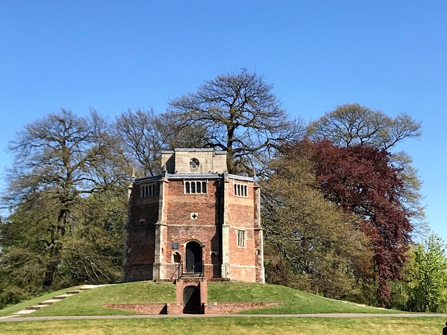
The Red Mount Chapel under a blue sky - King's Lynn
Weather for this location
Next 14 daysNearby places
Useful places within 5 km
Events & activities nearby
Switch provider to compare local events, tours and bookable activities.
Wildlife to spot
20,259 records · National Biodiversity Network
Wildlife to spot
20,259 records · National Biodiversity Network🐦Birds43 species
springsummerautumn
2026▾
Black-headed Gull · Woodpigeon · Mallard · Herring Gull · Rock Dove +38
- Black-headed GullChroicocephalus ridibundus
- WoodpigeonColumba palumbus2025
- MallardAnas platyrhynchos2025
- Herring GullLarus argentatus2025
- Rock DoveColumba livia2025
- BlackbirdTurdus merula2025
- House SparrowPasser domesticus2025
- Lesser Black-backed GullLarus fuscus2025
- JackdawColoeus monedula2025
- Common GullLarus canus2025
- MagpiePica pica2025
- TurnstoneArenaria interpres
- Carrion CrowCorvus corone2025
- Pink-footed GooseAnser brachyrhynchus2025
- RookCorvus frugilegus2025
- Lesser YellowlegsTringa flavipes2025
- Green SandpiperTringa ochropus2025
- Mute SwanCygnus olor2025
- StarlingSturnus vulgaris2025
- Collared DoveStreptopelia decaocto2025
- Blue TitCyanistes caeruleus2025
- Great Spotted WoodpeckerDendrocopos major2025
- Greylag GooseAnser anser2025
- Red-legged PartridgeAlectoris rufa2025
- Song ThrushTurdus philomelos2025
- BullfinchPyrrhula pyrrhula2025
- LinnetLinaria cannabina2025
- SnipeGallinago gallinago2025
- Grey WagtailMotacilla cinerea2025
- SkylarkAlauda arvensis2025
- Pied WagtailMotacilla alba yarrellii2025
- Great Black-backed GullLarus marinus2025
- CormorantPhalacrocorax carbo2025
- RobinErithacus rubecula2025
- SwiftApus apus2025
- KingfisherAlcedo atthis2025
- Little EgretEgretta garzetta2025
- Green WoodpeckerPicus viridis2025
- CuckooCuculus canorus2025
- Tawny OwlStrix aluco2025
- NuthatchSitta europaea2025
- TreecreeperCerthia familiaris2025
- Lesser WhitethroatCurruca curruca2025
Muntjac
Grass Snake
- Grass SnakeNatrix helvetica
🐝Insects25 species
springsummer
2025▾
Harlequin Ladybird · Eristalis tenax · Pine Ladybird · Sicus ferrugineus · Common Cockchafer +20
- Harlequin LadybirdHarmonia axyridis
- Eristalis tenaxEristalis tenax
- Pine LadybirdExochomus quadripustulatus
- Sicus ferrugineusSicus ferrugineus
- Common CockchaferMelolontha melolontha
- 14-spot LadybirdPropylea quattuordecimpunctata
🌿Plants26 species
springsummer
2026▾
Unbranched Bur-reed · Daisy · Cleavers · Arrowhead · Groundsel +21
- Unbranched Bur-reedSparganium emersum2025
- DaisyBellis perennis
- CleaversGalium aparine
- ArrowheadSagittaria sagittifolia2025
- GroundselSenecio vulgaris
- Germander SpeedwellVeronica chamaedrys
Species observations from the last 10 years via NBN Atlas