Plan your visit
🦅Birds🦉Wildlife🦋Insects
Public accessFree entryDogs welcome
Getting here
52.34882, 0.21818
Open directionsv
Visiting this summer
Seasonal nature notes and what to look for now
- 🐦74+ species recorded in this area — summer evenings are best for activity; watch for Woodpigeon and Carrion Crow
- ☀️Summer family visits work well here — arrive early and plan for a longer stay
- 🛝Playground 268m away — built-in entertainment for younger visitors alongside the wider site
🌤️ Visiting this summer
- 🐦74+ species recorded in this area — summer evenings are best for activity; watch for Woodpigeon and Carrion Crow
- ☀️Summer family visits work well here — arrive early and plan for a longer stay
- 🛝Playground 268m away — built-in entertainment for younger visitors alongside the wider site
- £Free to visit — no entry charge
- 🐕Dogs welcome
🦅Bird watching
Very strong match
Birds — Woodpigeon, Carrion Crow, Rook +71 more · last seen 2025
Free
Birds — Woodpigeon, Carrion Crow, Rook +71 more · last seen 2025
Free
🦋Insect spotting
Strong match
Insects — Macrosiphoniella (Phalangomyzus) oblonga, Macrosiphoniella (Macrosiphoniella) subterranea, Betulaphis quadrituberculata +337 more · last seen 2025
Free
Grade II* listed building: CHURCH OF ST JAMES; Religious grounds — local heritage
Free
🍂Seasonal nature
Strong match
Plants — Water Dock, Blunt-fruited Water-starwort, Fringed Water-lily +20 more · last seen 2021
Free
Trails nearby
Within roughly 5 km9 signed routes nearby · 8 public paths nearby
Signed route nearbyPublic paths
Four Lodes Trail at Wicken FenWalking route6.4 km▾
Grass paths following waterways. Made and unmade grass paths. Take care near waterways and ponds. Dogs welcome.
Named routeLength 6.4 kmDuration 01:30Round tripLocal walking route
Via BeataWalking route▾
A pilgrimage with a difference... with a dream to span Great Britain from Lowestoft to St Davids.
Named routeRegional walking route
Rothschild WayWalking route▾
Named routeLocal walking route
Fen Rivers Way (Cambridge to Ely)Walking route▾
Named routeRegional walking route
Ouse Valley Way 3 (Eaton Socon to Brandon Creek)Walking route▾
Named routeRegional walking route
Burying Waypublic footpath · 344 m▾
Public pathpublic footpathLength 344 mPath type: footway
23 signed routes nearby
Signed route nearby
NCN National Route 11Cycling route▾
Named routeRef 11National Cycle Network
Main RouteCycling route1.6 km▾
Named routeRef 11Length 1.6 kmNational Cycle NetworkTraffic-freeSurface unsealedfirm
Main RouteCycling route1.7 km▾
Named routeRef 11Length 1.7 kmNational Cycle NetworkOn-roadSurface asphalt
Main RouteCycling route1.3 km▾
Named routeRef 11Length 1.3 kmNational Cycle NetworkTraffic-freeSurface unsealedfirm
Main RouteCycling route68 m▾
Named routeRef 11Length 68 mNational Cycle NetworkOn-roadSurface asphalt
Main RouteCycling route350 m▾
Named routeRef 11Length 350 mNational Cycle NetworkTraffic-freeSurface asphalt
1 public path nearby
Public paths
Mill Waybyway open to all traffic · 1.4 km▾
Public pathbyway open to all trafficLength 1.4 kmSurface unpavedPath type: track
Photos
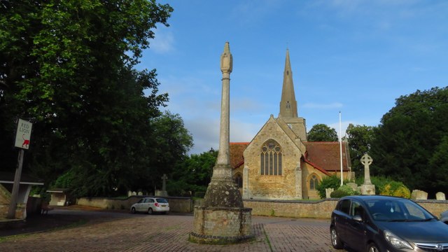
Stretham - St James's Church
Weather for this location
Next 14 daysNearby places
Useful places within 5 km
Events & activities nearby
Switch provider to compare local events, tours and bookable activities.
Wildlife to spot
16,117 records · National Biodiversity Network
Wildlife to spot
16,117 records · National Biodiversity Network🐦Birds27 species
springwinter
2025▾
Carrion Crow · Woodpigeon · Rook · Pheasant · Jackdaw +22
- Carrion CrowCorvus corone
- WoodpigeonColumba palumbus
- RookCorvus frugilegus
- PheasantPhasianus colchicus
- JackdawColoeus monedula
- MagpiePica pica
- StarlingSturnus vulgaris
- Black-headed GullChroicocephalus ridibundus
- Rock DoveColumba livia
- SwallowHirundo rustica
- BlackbirdTurdus merula
- ChaffinchFringilla coelebs
- Blue TitCyanistes caeruleus
- DunnockPrunella modularis
- GreenfinchChloris chloris
- GoldfinchCarduelis carduelis
- Song ThrushTurdus philomelos
- KestrelFalco tinnunculus
- ChiffchaffPhylloscopus collybita
- Mute SwanCygnus olor
- LapwingVanellus vanellus
- MallardAnas platyrhynchos
- WrenTroglodytes troglodytes
- RobinErithacus rubecula
- Mistle ThrushTurdus viscivorus
- Cetti's WarblerCettia cetti
- Reed BuntingEmberiza schoeniclus
Roe Deer · Rabbit · Sika Deer · Brown Hare
- Roe DeerCapreolus capreolus
- RabbitOryctolagus cuniculus2025
- Sika DeerCervus nippon2025
- Brown HareLepus europaeus2025
Macrosiphoniella (Phalangomyzus) oblonga · Macrosiphoniella (Macrosiphoniella) subterranea · Macrosiphoniella (Macrosiphoniella) artemisiae · Betulaphis quadrituberculata · Myzus (Myzus) varians +40
- Macrosiphoniella (Phalangomyzus) oblongaMacrosiphoniella (Phalangomyzus) oblonga2024
- Macrosiphoniella (Macrosiphoniella) subterraneaMacrosiphoniella (Macrosiphoniella) subterranea2024
- Macrosiphoniella (Macrosiphoniella) artemisiaeMacrosiphoniella (Macrosiphoniella) artemisiae2024
- Betulaphis quadrituberculataBetulaphis quadrituberculata2024
- Myzus (Myzus) varians
Species observations from the last 10 years via NBN Atlas
Myzus (Myzus) varians2024
Myzus (Myzus) varians2024
Brachycaudus (Prunaphis) carduiBrachycaudus (Prunaphis) cardui2024Brachycaudus (Prunaphis) carduiBrachycaudus (Prunaphis) cardui2024Dicyphus (Brachyceroea) globuliferDicyphus (Brachyceroea) globulifer2024Dicyphus (Brachyceroea) globuliferDicyphus (Brachyceroea) globulifer2024Macrosiphum (Macrosiphum) geiMacrosiphum (Macrosiphum) gei2024Macrosiphum (Macrosiphum) geiMacrosiphum (Macrosiphum) gei2024Macrosiphoniella (Macrosiphoniella) millefoliiMacrosiphoniella (Macrosiphoniella) millefolii2024Macrosiphoniella (Macrosiphoniella) millefoliiMacrosiphoniella (Macrosiphoniella) millefolii2024Dicyphus (Dicyphus) erransDicyphus (Dicyphus) errans2024Dicyphus (Dicyphus) erransDicyphus (Dicyphus) errans2024Dicranotropis hamataDicranotropis hamata2024Dicranotropis hamataDicranotropis hamata2024Aulacorthum (Aulacorthum) solaniAulacorthum (Aulacorthum) solani2024Aulacorthum (Aulacorthum) solaniAulacorthum (Aulacorthum) solani2024Tinocallis (Sappocallis) nevskyiTinocallis (Sappocallis) nevskyi2024Tinocallis (Sappocallis) nevskyiTinocallis (Sappocallis) nevskyi2024Large Walnut AphidPanaphis juglandis2024Large Walnut AphidPanaphis juglandis2024Euceraphis betulaeEuceraphis betulae2024Euceraphis betulaeEuceraphis betulae2024Chlamydatus (Eurymerocoris) evanescensChlamydatus (Eurymerocoris) evanescens2024Chlamydatus (Eurymerocoris) evanescensChlamydatus (Eurymerocoris) evanescens2024Dicyphus (Brachyceroea) annulatusDicyphus (Brachyceroea) annulatus2024Dicyphus (Brachyceroea) annulatusDicyphus (Brachyceroea) annulatus2024Common DarterSympetrum striolatum2024Common DarterSympetrum striolatum2024Myzocallis (Myzocallis) carpiniMyzocallis (Myzocallis) carpini2024Myzocallis (Myzocallis) carpiniMyzocallis (Myzocallis) carpini2024Walnut AphidChromaphis juglandicola2024Walnut AphidChromaphis juglandicola2024Myzocallis (Myzocallis) coryliMyzocallis (Myzocallis) coryli2024Myzocallis (Myzocallis) coryliMyzocallis (Myzocallis) coryli2024Javesella pellucidaJavesella pellucida2024Javesella pellucidaJavesella pellucida2024Aphidius asterisAphidius asteris2024Aphidius asterisAphidius asteris2024MordellidaeMordellidae2024MordellidaeMordellidae2024Green ShieldbugPalomena prasinaGreen ShieldbugPalomena prasinaPhysatocheila dumetorumPhysatocheila dumetorum2024Physatocheila dumetorumPhysatocheila dumetorum2024Uroleucon (Uromelan) jaceaeUroleucon (Uromelan) jaceae2024Uroleucon (Uromelan) jaceaeUroleucon (Uromelan) jaceae2024Nettle GroundbugHeterogaster urticae2024Nettle GroundbugHeterogaster urticae2024Dock BugCoreus marginatus2024Dock BugCoreus marginatus2024Field GrasshopperChorthippus brunneus2024Field GrasshopperChorthippus brunneus20247-spot LadybirdCoccinella septempunctata20247-spot LadybirdCoccinella septempunctata2024Marmalade HoverflyEpisyrphus balteatus2024Marmalade HoverflyEpisyrphus balteatus2024Eristalis tenaxEristalis tenax2024Eristalis tenaxEristalis tenax2024Pilophorus perplexusPilophorus perplexus2024Pilophorus perplexusPilophorus perplexus2024Dyscritulus planicepsDyscritulus planiceps2024Dyscritulus planicepsDyscritulus planiceps2024GelisGelis2024GelisGelis2024Striped Bent-wingLyonetia prunifoliella2024Striped Bent-wingLyonetia prunifoliella2024Anoecia (Anoecia) corniAnoecia (Anoecia) corni2024Anoecia (Anoecia) corniAnoecia (Anoecia) corni2024Stenocranus majorStenocranus major2024Stenocranus majorStenocranus major2024Figwort SawflyTenthredo scrophulariae2024Figwort SawflyTenthredo scrophulariae2024Hornet HoverflyVolucella zonaria2024Hornet HoverflyVolucella zonaria2024Uroleucon (Uromelan) montanivorumUroleucon (Uromelan) montanivorum2024Uroleucon (Uromelan) montanivorumUroleucon (Uromelan) montanivorum2024Megourella purpureaMegourella purpurea2024Megourella purpureaMegourella purpurea2024Aphis (Aphis) taraxacicolaAphis (Aphis) taraxacicola2024Aphis (Aphis) taraxacicolaAphis (Aphis) taraxacicola2024Lysiphlebus confususLysiphlebus confusus2024Lysiphlebus confususLysiphlebus confusus2024