Plan your visit
🦉 Wildlife🦅 Birds🦋 Insects
Public access Free entry Dogs welcome
Places › England › East Midlands › Derbyshire Dales Getting here
52.98108, -1.73147
Open directionsv Visiting this summer
Seasonal nature notes and what to look for now
▾ 🌞 Midsummer — early morning visits most comfortable; look for deer fawns in quieter clearings 🌿 Foraging is at its best in summer here 🐕 Dogs welcome — bring water in summer; the site has enough space to find shade on hot days 🌤️ Visiting this summer
🌞 Midsummer — early morning visits most comfortable; look for deer fawns in quieter clearings 🌿 Foraging is at its best in summer here 🐕 Dogs welcome — bring water in summer; the site has enough space to find shade on hot days £ Free to visit — no entry charge🐕 Dogs welcome🦉 Wildlife
Very strong match
Multi-group wildlife — Amphibians, Birds, Mammals; Multi-group wildlife — Amphibians, Birds, Mammals
Free
🦅 Bird watching
Very strong match
Birds — Blackbird, Wren, Carrion Crow +70 more · last seen 2025; Birds — Blackbird, Wren, Carrion Crow +70 more · last seen 2025
Free
🦋 Insect spotting
Strong match
Insects — Small White, Large White, Peacock +64 more · last seen 2025; Insects — Small White, Large White, Peacock +64 more · last seen 2025
Free
🍂 Seasonal nature
Strong match
Plants — Capillary Thread-moss, Cylindric Beard-moss, Wall Screw-moss +113 more · last seen 2021; Plants — Capillary Thread-moss, Cylindric Beard-moss, Wall Screw-moss +113 more · last seen 2021
Free
Plants — Garlic Mustard, Common Nettle, Wood-sorrel +7 more foraging species
Varies
Dogs allowed with public access
Free
Trails nearby Within roughly 5 km 5 signed routes nearby · 9 public paths nearby
Signed route nearby Public paths
Limestone Way Walking route 74 km ▾
Castleton to Rocester
Named route Length 74 km Point-to-point Regional walking route
Show on map Centenary Way (Derbyshire) Walking route ▾
Weaver Walk Walking route ▾
Named route Local walking route
Show on map Royal Shrovetide Challenge Walk (down'ards) Walking route ▾
Bonnie Prince Charlie Walk Walking route 28 km ▾
Named route Length 28 km Local walking route
Show on map 14 signed routes nearby
Signed route nearby
Pennine Cycleway Cycling route ▾
Named route Ref 68 National Cycle Network
Show on map Main Route Cycling route 450 m ▾
Named route Ref 68 Length 450 m National Cycle Network On-road Surface asphalt
Show on map Main Route Cycling route 225 m ▾
Named route Ref 68 Length 225 m National Cycle Network On-road Surface asphalt
Show on map Main Route Cycling route 11.5 km ▾
Named route Ref 68 Length 11.5 km National Cycle Network On-road Surface asphalt
Show on map Main Route Cycling route 582 m ▾
Named route Ref 68 Length 582 m National Cycle Network Traffic-free Surface asphalt
Show on map Main Route Cycling route 1.1 km ▾
Named route Ref 68 Length 1.1 km National Cycle Network Traffic-free Surface bareearth
Show on map 1 signed route nearby
Signed route nearby
Tissington Trail Mountain bike route ▾
Named route Ref Tissington Trail Point-to-point Local cycle route
Show on map 2 public paths nearby
Public paths
No named routes yet. Public paths are shown on the map.
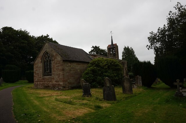
Photos St James Church, Edlaston
‹ ›
Weather for this location Next 14 days Nearby places Useful places within 5 km
All Historic
Own or manage this place?
Claim this listing to keep details accurate, add photos, and highlight what makes it special — free.
Claim this page→ How useful was the information on this page?
id: a49abce4-bb52-46f1-8b69-5ab100c1bd7a
UK green spaces mapped from open public data — so anyone can find the woodland, trail, or nature reserve closest to them.
© 2026 Glade · Made with care for UK green spaces
Events & activities nearby Switch provider to compare local events, tours and bookable activities.
Bookable tours GetYourGuide Promote here
Wildlife to spot
3,875 records · National Biodiversity Network
▾
Wildlife to spot 3,875 records · National Biodiversity Network Raven · Tawny Owl · Swallow · Carrion Crow · Blackbird +41
Raven Corvus corax Tawny Owl Strix aluco Swallow Hirundo rustica2024 Carrion Crow Corvus corone Blackbird Turdus merula Woodpigeon Columba palumbus Black-headed Gull Chroicocephalus ridibundus Pheasant Phasianus colchicus Goldcrest Regulus regulus Great Spotted Woodpecker Dendrocopos major Greylag Goose Anser anser2024 Spotted Flycatcher Muscicapa striata2024 Redwing Turdus iliacus Pied Wagtail Motacilla alba yarrellii Fieldfare Turdus pilaris Linnet Linaria cannabina Nuthatch Sitta europaea Coot Fulica atra2024 Oystercatcher Haematopus ostralegus2024 Jackdaw Coloeus monedula2024 Blue Tit Cyanistes caeruleus2024 House Sparrow Passer domesticus2024 Yellowhammer Emberiza citrinella2024 Treecreeper Certhia familiaris2024 Chiffchaff Phylloscopus collybita2024 Starling Sturnus vulgaris2024 Mallard Anas platyrhynchos2024 Magpie Pica pica2024 Wren Troglodytes troglodytes2024 Dunnock Prunella modularis2024 Greenfinch Chloris chloris2024 Great Tit Parus major2024 Song Thrush Turdus philomelos2024 Tufted Duck Aythya fuligula2024 Chaffinch Fringilla coelebs2024 Grey Heron Ardea cinerea2024 Goldfinch Carduelis carduelis2024 Blackcap Sylvia atricapilla2024 Robin Erithacus rubecula2024 Canada Goose Branta canadensis2024 Whitethroat Curruca communis2024 Mistle Thrush Turdus viscivorus2024 Willow Tit Poecile montanus2024 Mute Swan Cygnus olor2024 Teal Anas crecca2024 House Martin Delichon urbicum2024 🐸 Amphibians 1 species
spring
2025 ▾
Common Toad
Notiophilus biguttatus · Black Clock · Nebria salina · Leistus rufomarginatus
Notiophilus biguttatus Notiophilus biguttatus Black Clock Pterostichus madidus Nebria salina Nebria salina Leistus rufomarginatus Leistus rufomarginatus Bush Vetch · White Dead-nettle · Perennial Rye-grass · Bramble · Dandelion +119
Bush Vetch Vicia sepium White Dead-nettle Lamium album Perennial Rye-grass Lolium perenne Bramble Rubus fruticosus Dandelion Taraxacum Hedge Bindweed Calystegia sepium Gorse Ulex europaeus Species observations from the last 10 years via NBN Atlas
Brooklime Veronica beccabunga
Brooklime Veronica beccabunga
Ribwort Plantain Plantago lanceolata
Ribwort Plantain Plantago lanceolata
Goat Willow Salix caprea
Goat Willow Salix caprea
Cherry Plum Prunus cerasifera
Cherry Plum Prunus cerasifera
Crab Apple Malus sylvestris
Crab Apple Malus sylvestris
Prickly Sow-thistle Sonchus asper
Prickly Sow-thistle Sonchus asper
Marsh Cudweed Gnaphalium uliginosum
Marsh Cudweed Gnaphalium uliginosum
Cuckooflower Cardamine pratensis
Cuckooflower Cardamine pratensis
Tufted Vetch Vicia cracca
Tufted Vetch Vicia cracca
Nipplewort Lapsana communis
Nipplewort Lapsana communis
Ragged-Robin Silene flos-cuculi
Ragged-Robin Silene flos-cuculi
Wood Sage Teucrium scorodonia
Wood Sage Teucrium scorodonia
Common Sorrel Rumex acetosa
Common Sorrel Rumex acetosa
Greater Stitchwort Stellaria holostea
Greater Stitchwort Stellaria holostea
Tufted Forget-me-not Myosotis laxa
Tufted Forget-me-not Myosotis laxa
Alder Alnus glutinosa
Alder Alnus glutinosa
Field-rose Rosa arvensis
Field-rose Rosa arvensis
Marsh Ragwort Jacobaea aquatica
Marsh Ragwort Jacobaea aquatica
Clustered Dock Rumex conglomeratus
Clustered Dock Rumex conglomeratus
Foxglove Digitalis purpurea
Foxglove Digitalis purpurea
Spear Thistle Cirsium vulgare
Spear Thistle Cirsium vulgare
Hedge Woundwort Stachys sylvatica
Hedge Woundwort Stachys sylvatica
Valeriana officinalis subsp. sambucifolia Valeriana officinalis subsp. sambucifolia
Valeriana officinalis subsp. sambucifolia Valeriana officinalis subsp. sambucifolia
Meadowsweet Filipendula ulmaria
Meadowsweet Filipendula ulmaria
Daisy Bellis perennis
Daisy Bellis perennis
Red Fescue Festuca rubra
Red Fescue Festuca rubra
Bittersweet Solanum dulcamara
Bittersweet Solanum dulcamara
Tufted Hair-grass Deschampsia cespitosa
Tufted Hair-grass Deschampsia cespitosa
Germander Speedwell Veronica chamaedrys
Germander Speedwell Veronica chamaedrys
Marsh Willowherb Epilobium palustre
Marsh Willowherb Epilobium palustre
Common Vetch Vicia sativa
Common Vetch Vicia sativa
Curled Dock Rumex crispus
Curled Dock Rumex crispus
Knotgrass Polygonum aviculare
Knotgrass Polygonum aviculare
Swine-cress Lepidium coronopus
Swine-cress Lepidium coronopus
Hyacinthoides Hyacinthoides
Hyacinthoides Hyacinthoides
Sticky Mouse-ear Cerastium glomeratum
Sticky Mouse-ear Cerastium glomeratum
Red Clover Trifolium pratense
Red Clover Trifolium pratense
Shining Crane's-bill Geranium lucidum
Shining Crane's-bill Geranium lucidum
Wild Angelica Angelica sylvestris
Wild Angelica Angelica sylvestris
Marsh Foxtail Alopecurus geniculatus
Marsh Foxtail Alopecurus geniculatus
Common Mouse-ear Cerastium fontanum
Common Mouse-ear Cerastium fontanum
Meadow Fescue Schedonorus pratensis
Meadow Fescue Schedonorus pratensis
Pineappleweed Matricaria discoidea
Pineappleweed Matricaria discoidea
Shepherd's-purse Capsella bursa-pastoris
Shepherd's-purse Capsella bursa-pastoris
Thyme-leaved Speedwell Veronica serpyllifolia
Thyme-leaved Speedwell Veronica serpyllifolia
Timothy Phleum pratense
Timothy Phleum pratense
Sweet Vernal-grass Anthoxanthum odoratum
Sweet Vernal-grass Anthoxanthum odoratum
Floating Sweet-grass Glyceria fluitans
Floating Sweet-grass Glyceria fluitans
Black-grass Alopecurus myosuroides
Black-grass Alopecurus myosuroides
Great Willowherb Epilobium hirsutum
Great Willowherb Epilobium hirsutum
Lesser Stitchwort Stellaria graminea
Lesser Stitchwort Stellaria graminea
Soft-rush Juncus effusus
Soft-rush Juncus effusus
Crested Dog's-tail Cynosurus cristatus
Crested Dog's-tail Cynosurus cristatus
Marsh-bedstraw Galium palustre
Marsh-bedstraw Galium palustre
Blue Water-speedwell Veronica anagallis-aquatica
Blue Water-speedwell Veronica anagallis-aquatica
Reed Sweet-grass Glyceria maxima
Reed Sweet-grass Glyceria maxima
Cleavers Galium aparine
Cleavers Galium aparine
Sycamore Acer pseudoplatanus
Sycamore Acer pseudoplatanus
Wild Strawberry Fragaria vesca
Wild Strawberry Fragaria vesca
Ground-ivy Glechoma hederacea
Ground-ivy Glechoma hederacea
Holly Ilex aquifolium
Holly Ilex aquifolium
Broad-leaved Dock Rumex obtusifolius
Broad-leaved Dock Rumex obtusifolius
Red Currant Ribes rubrum
Red Currant Ribes rubrum
Field Horsetail Equisetum arvense
Field Horsetail Equisetum arvense
Male-fern Dryopteris filix-mas
Male-fern Dryopteris filix-mas
Wood Anemone Anemone nemorosa
Wood Anemone Anemone nemorosa
Annual Meadow-grass Poa annua
Annual Meadow-grass Poa annua
Broad Buckler-fern Dryopteris dilatata
Broad Buckler-fern Dryopteris dilatata
Yellow Iris Iris pseudacorus
Yellow Iris Iris pseudacorus
Ash Fraxinus excelsior
Ash Fraxinus excelsior
Ivy Hedera helix
Ivy Hedera helix
Meadow Vetchling Lathyrus pratensis
Meadow Vetchling Lathyrus pratensis
Yorkshire-fog Holcus lanatus
Yorkshire-fog Holcus lanatus
Meadow Buttercup Ranunculus acris
Meadow Buttercup Ranunculus acris
Rough Meadow-grass Poa trivialis
Rough Meadow-grass Poa trivialis
Hazel Corylus avellana
Hazel Corylus avellana
False-brome Brachypodium sylvaticum
False-brome Brachypodium sylvaticum
Rosebay Willowherb Chamaenerion angustifolium
Rosebay Willowherb Chamaenerion angustifolium
Wych Elm Ulmus glabra
Wych Elm Ulmus glabra
Wood Avens Geum urbanum
Wood Avens Geum urbanum
False Oat-grass Arrhenatherum elatius
False Oat-grass Arrhenatherum elatius
Pedunculate Oak Quercus robur
Pedunculate Oak Quercus robur
Soft-brome Bromus hordeaceus
Soft-brome Bromus hordeaceus
Silverweed Potentilla anserina
Silverweed Potentilla anserina
Hawthorn Crataegus monogyna
Hawthorn Crataegus monogyna
Tea-leaved Willow Salix phylicifolia
Tea-leaved Willow Salix phylicifolia
Hogweed Heracleum sphondylium
Hogweed Heracleum sphondylium
Field Maple Acer campestre
Field Maple Acer campestre
Centaurea nigra Centaurea nigra
Centaurea nigra Centaurea nigra
Creeping Thistle Cirsium arvense
Creeping Thistle Cirsium arvense
White Clover Trifolium repens
White Clover Trifolium repens
Honeysuckle Lonicera periclymenum
Honeysuckle Lonicera periclymenum
Dog's Mercury Mercurialis perennis
Dog's Mercury Mercurialis perennis
Cock's-foot Dactylis glomerata
Cock's-foot Dactylis glomerata
Common Ragwort Jacobaea vulgaris
Common Ragwort Jacobaea vulgaris
Lime Tilia cordata x platyphyllos = T. x europaea
Lime Tilia cordata x platyphyllos = T. x europaea
Barren Brome Anisantha sterilis
Barren Brome Anisantha sterilis
Common Nettle Urtica dioica
Common Nettle Urtica dioica
Herb-Robert Geranium robertianum
Herb-Robert Geranium robertianum
Garlic Mustard Alliaria petiolata
Garlic Mustard Alliaria petiolata
Lamiastrum galeobdolon subsp. montanum Lamiastrum galeobdolon subsp. montanum
Lamiastrum galeobdolon subsp. montanum Lamiastrum galeobdolon subsp. montanum
Reed Canary-grass Phalaris arundinacea
Reed Canary-grass Phalaris arundinacea
Greater Plantain Plantago major
Greater Plantain Plantago major
White Bryony Bryonia dioica
White Bryony Bryonia dioica
Red Campion Silene dioica
Red Campion Silene dioica
Dog-rose Rosa canina
Dog-rose Rosa canina
Bracken Pteridium aquilinum
Bracken Pteridium aquilinum
Blackthorn Prunus spinosa
Blackthorn Prunus spinosa
Cow Parsley Anthriscus sylvestris
Cow Parsley Anthriscus sylvestris
Pignut Conopodium majus
Pignut Conopodium majus
American Skunk-cabbage Lysichiton americanus
American Skunk-cabbage Lysichiton americanus
Moschatel Adoxa moschatellina
Moschatel Adoxa moschatellina
Field Wood-rush Luzula campestris
Field Wood-rush Luzula campestris
Greater Celandine Chelidonium majus
Greater Celandine Chelidonium majus
Purple Willow Salix purpurea
Purple Willow Salix purpurea
Bluebell Hyacinthoides non-scripta
Bluebell Hyacinthoides non-scripta
Gooseberry Ribes uva-crispa
Gooseberry Ribes uva-crispa