Plan your visit
🦅Birds✦Heritage🦉Wildlife
Public accessDogs welcome52 ha
Getting here
51.81537, -1.87346
Open directionsv
Visiting this summer
Seasonal nature notes and what to look for now
- 🐦58+ species recorded in this area — summer evenings are best for activity; watch for Woodpigeon and Skylark
- ✦Historic character is a year-round quality here — summer brings its own atmosphere to the setting
- 🐕Dogs welcome — bring water in summer; the site has enough space to find shade on hot days
🌤️ Visiting this summer
- 🐦58+ species recorded in this area — summer evenings are best for activity; watch for Woodpigeon and Skylark
- ✦Historic character is a year-round quality here — summer brings its own atmosphere to the setting
- 🐕Dogs welcome — bring water in summer; the site has enough space to find shade on hot days
🦅Bird watching
Very strong match
Birds — Woodpigeon, Skylark, Kestrel +55 more · last seen 2025; Deciduous woodland — woodpeckers, warblers and woodland birds
Free
✦Heritage
Very strong match
Grade I listed building: CHURCH OF ST LEONARD; Historic site with public access
Free
Birds — Woodpigeon, Skylark, Kestrel +55 more · last seen 2025; Deciduous woodland priority habitat
Free
🦋Insect spotting
Strong match
Insects — Large White, Small White, Small Tortoiseshell +42 more · last seen 2022
Free
Dogs allowed with public access
Free
Deciduous woodland — fungi, berries and wild garlic
Varies
Trails nearby
Within roughly 5 km3 signed routes nearby · 10 public paths nearby
Signed route nearbyPublic paths
Monarch's WayWalking route990 km▾
approximate route of Charles II's escape
Named routeRef MWLength 990 kmRegional walking route
Diamond WayWalking route106 km▾
Named routeRef DIALength 106 kmRegional walking route
Macmillan WayWalking route290 km▾
Named routeRef MWALength 290 kmListed length 461Regional walking route
15 signed routes nearby
Signed route nearby
Fosse2Cycling route▾
Named routeRef 48National Cycle Network
Fosse2Cycling route▾
Named routeRef 48National Cycle Network
NCN National Route 57Cycling route▾
Named routeRef 57National Cycle Network
National Byway (Oxon and Glos)Cycling route▾
Named routeRef NBRegional cycle route
Main RouteCycling route92 m▾
Named routeRef 48Length 92 mNational Cycle NetworkOn-roadSurface asphalt
Main RouteCycling route769 m▾
Named routeRef 48Length 769 mNational Cycle NetworkOn-roadSurface asphalt
1 public path nearby
Public paths
No named routes yet. Public paths are shown on the map.
Photos
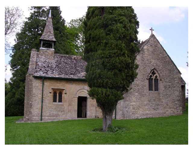
The church at Stowell Park
Weather for this location
Next 14 daysNearby places
Useful places within 5 km
Events & activities nearby
Switch provider to compare local events, tours and bookable activities.
Wildlife to spot
2,361 records · National Biodiversity Network
Wildlife to spot
2,361 records · National Biodiversity Network🐦Birds47 species
winterautumn
2025▾
Skylark · Woodpigeon · Kestrel · Pied Wagtail · Stonechat +42
- SkylarkAlauda arvensis
- WoodpigeonColumba palumbus
- KestrelFalco tinnunculus
- Pied WagtailMotacilla alba
- StonechatSaxicola rubicola
- House SparrowPasser domesticus
- Collared DoveStreptopelia decaocto
- JackdawColoeus monedula2024
- JayGarrulus glandarius
- Stock DoveColumba oenas
- BlackbirdTurdus merula
- SwallowHirundo rustica
- GoldfinchCarduelis carduelis
- FieldfareTurdus pilaris
- Blue TitCyanistes caeruleus2024
- RavenCorvus corax2024
- Carrion CrowCorvus corone2024
- RookCorvus frugilegus2024
- Great Spotted WoodpeckerDendrocopos major2024
- RobinErithacus rubecula2024
- House MartinDelichon urbicum
- Mistle ThrushTurdus viscivorus
- StarlingSturnus vulgaris
- LinnetLinaria cannabina2023
- ChaffinchFringilla coelebs2023
- WrenTroglodytes troglodytes2023
- Great TitParus major2023
- Song ThrushTurdus philomelos2023
- PheasantPhasianus colchicus2023
- YellowhammerEmberiza citrinella2022
- Marsh TitPoecile palustris
- RedwingTurdus iliacus
- Mute SwanCygnus olor2024
- SwiftApus apus2024
- Grey PartridgePerdix perdix2024
- WheatearOenanthe oenanthe2023
- GreenfinchChloris chloris2023
- Little EgretEgretta garzetta2023
- SiskinSpinus spinus2022
- NuthatchSitta europaea2022
- Meadow PipitAnthus pratensis2022
- Red-legged PartridgeAlectoris rufa2022
- TreecreeperCerthia familiaris2022
- GoldcrestRegulus regulus2022
- Coal TitPeriparus ater2022
- MagpiePica pica2022
- DunnockPrunella modularis2022
🦌Mammals2 species
springautumn
2025▾
Brown Hare · Hedgehog
- Brown HareLepus europaeus
- HedgehogErinaceus europaeus2023
Large White · Small White · Red Admiral · Common Blue · Meadow Brown +9
- Large WhitePieris brassicae
- Small WhitePieris rapae
- Red AdmiralVanessa atalanta
- Common BluePolyommatus icarus
- Meadow BrownManiola jurtina
- CommaPolygonia c-album
- Green-veined WhitePieris napi
Species observations from the last 10 years via NBN Atlas