Upper Astley Wood ✦ Ancient woodland 116 ha
Plan your visit
🦅 Birds🦉 Wildlife🍂 Seasonal
Public access Free entry Dogs welcome 116 ha
Places › England › West Midlands › Malvern Hills Getting here
52.29188, -2.28323
Open directionsv Visiting this summer
Seasonal nature notes and what to look for now
▾ 🐦 51+ species recorded in this area — summer evenings are best for activity; watch for Wren and Blackcap 🍄 Mushroom foraging is at its best in summer here 🐕 Dogs welcome — bring water in summer; the site has enough space to find shade on hot days 🌤️ Visiting this summer
🐦 51+ species recorded in this area — summer evenings are best for activity; watch for Wren and Blackcap 🍄 Mushroom foraging is at its best in summer here 🐕 Dogs welcome — bring water in summer; the site has enough space to find shade on hot days £ Free to visit — no entry charge🐕 Dogs welcome🌿 Ancient woodland — rare wildlife habitat🌳 Large woodland — room to roam🦅 Bird watching
Very strong match
Birds — Wren, Blackcap, Blackbird +48 more · last seen 2025; Birds — Wren, Blackcap, Blackbird +48 more · last seen 2025
Free
🦉 Wildlife
Very strong match
Multi-group wildlife — Birds, Mammals; Multi-group wildlife — Birds, Mammals
Free
🍂 Seasonal nature
Strong match
Ancient woodland — bluebells, fungi and autumn colour; Plants — Crescent-cup Liverwort · last seen 2025
Free
🍄 Mushroom foraging
Strong match
Fungi — White Fibrecap, Rosy Bonnet, Tawny Funnel +40 more · last seen 2024; Fungi — White Fibrecap, Rosy Bonnet, Tawny Funnel +40 more · last seen 2024
Varies
Traditional orchard — seasonal fruit, fungi and wild plants; Fungi — Tawny Funnel, Slender Parasol, Jelly Tooth +2 more foraging species
Varies
Dogs allowed — public woodland
Free
Trails nearby Within roughly 5 km 7 signed routes nearby · 103 public paths nearby
Signed route nearby Public paths
Martley Circular Walk Walking route 6.3 km ▾
Named route Length 6.3 km Local walking route
Show on map Wychavon Way (old) Walking route 67 km ▾
A route from Holt Fleet on the River Severn to Winchcombe in the Cotswolds.
Named route Length 67 km
Show on map Severn Way (2) Shrewsbury to Worcester Walking route 93 km ▾
Named route Ref SW (2) Length 93 km Regional walking route
Show on map Worcestershire Way Walking route 50 km ▾
Walking route from Bewdley to Great Malvern
Named route Length 50 km Regional walking route
Show on map Geopark Way Walking route 175 km ▾
Named route Ref geo Length 175 km Regional walking route
Show on map New Inn Lane public footpath · 27 m ▾
Public path public footpath Length 27 m Path type: service
Show on map New Inn Lane public footpath · 218 m ▾
Public path public footpath Length 218 m Path type: residential
Show on map New Inn Lane public footpath · 131 m ▾
Public path public footpath Length 131 m Path type: service
Show on map 9 signed routes nearby
Signed route nearby
Mercian Way Cycling route ▾
Named route Ref 45 National Cycle Network
Show on map Northwick - Ladywood Cycle Leisure Route Cycling route 10.5 km ▾
Circular route starting at the Pump House Environment Centre and covering a mixture of quiet lanes and residential streets.The route is 10.5 miles with a short cut that reduces it to 6.5 miles.
Named route Length 10.5 km Round trip Local cycle route
Show on map Main Route Cycling route 2.7 km ▾
Named route Ref 45 Length 2.7 km National Cycle Network On-road Surface asphalt
Show on map Main Route Cycling route 754 m ▾
Named route Ref 45 Length 754 m National Cycle Network On-road Surface asphalt
Show on map Main Route Cycling route 955 m ▾
Named route Ref 45 Length 955 m National Cycle Network On-road Surface asphalt
Show on map Main Route Cycling route 2.3 km ▾
Named route Ref 45 Length 2.3 km National Cycle Network On-road Surface asphalt
Show on map 20 public paths nearby
Public paths
No named routes yet. Public paths are shown on the map.
✦ Ancient woodland — continuously wooded since at least 1600 AD. A rare and irreplaceable habitat, rich in biodiversity and historical character.
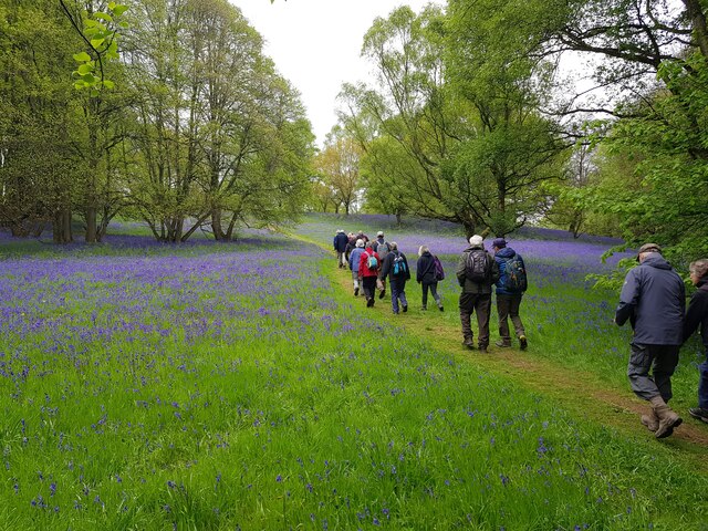
Photos Walkers amongst the bluebells, Shrawley Wood
‹ ›
Weather for this location Next 14 days Nearby places Useful places within 5 km
All Historic
Own or manage this place?
Claim this listing to keep details accurate, add photos, and highlight what makes it special — free.
Claim this page→ How useful was the information on this page?
id: 4631ba08-4c3f-4335-ae79-966daad822ab
UK green spaces mapped from open public data — so anyone can find the woodland, trail, or nature reserve closest to them.
© 2026 Glade · Made with care for UK green spaces
Wildlife to spot
9,776 records · National Biodiversity Network
▾
Wildlife to spot 9,776 records · National Biodiversity Network 🐦 Birds 33 species
spring summer autumn
2025 ▾
Treecreeper · Jay · Tawny Owl · Swift · Blue Tit +28
Treecreeper Certhia familiaris Jay Garrulus glandarius Tawny Owl Strix aluco2024 Swift Apus apus Blue Tit Cyanistes caeruleus Woodpigeon Columba palumbus Robin Erithacus rubecula Great Tit Parus major Blackbird Turdus merula Long-tailed Tit Aegithalos caudatus Wren Troglodytes troglodytes Nuthatch Sitta europaea2024 Mallard Anas platyrhynchos2024 Coot Fulica atra2024 Raven Corvus corax Great Spotted Woodpecker Dendrocopos major Goldfinch Carduelis carduelis Goldcrest Regulus regulus Blackcap Sylvia atricapilla Song Thrush Turdus philomelos Chaffinch Fringilla coelebs Chiffchaff Phylloscopus collybita Herring Gull Larus argentatus2024 Pied Wagtail Motacilla alba yarrellii2024 Greenfinch Chloris chloris2024 Carrion Crow Corvus corone2024 Magpie Pica pica2024 House Martin Delichon urbicum2024 Little Grebe Tachybaptus ruficollis2024 Moorhen Gallinula chloropus2024 Grey Heron Ardea cinerea2024 Mute Swan Cygnus olor2024 Collared Dove Streptopelia decaocto2024 Muntjac
Anoplotrupes stercorosus · Azure Damselfly · White-legged Damselfly · Banded Demoiselle · Common Blue Damselfly +21
Anoplotrupes stercorosus Anoplotrupes stercorosus Azure Damselfly Coenagrion puella White-legged Damselfly Platycnemis pennipes Banded Demoiselle Calopteryx splendens Common Blue Damselfly Enallagma cyathigerum2024 Blue-tailed Damselfly Ischnura elegans2024 Honey Fungus · Hairy Curtain Crust · Butter Cap · Blushing Bracket · Common Puffball +83
Honey Fungus Armillaria mellea Hairy Curtain Crust Stereum hirsutum Butter Cap Rhodocollybia butyracea Blushing Bracket Daedaleopsis confragosa Common Puffball Lycoperdon perlatum White Fibrecap Inocybe geophylla Slender Parasol Crescent-cup Liverwort
Crescent-cup Liverwort Lunularia cruciata Species observations from the last 10 years via NBN Atlas
Ruddy Darter Sympetrum sanguineum2024
Ruddy Darter Sympetrum sanguineum2024
Emperor Dragonfly Anax imperator2024
Emperor Dragonfly Anax imperator2024
Rutpela maculata Rutpela maculata2024
Rutpela maculata Rutpela maculata2024
Dock Bug Coreus marginatus
Dock Bug Coreus marginatus
Minotaur Beetle Typhaeus typhoeus
Minotaur Beetle Typhaeus typhoeus
Hairy Shieldbug Dolycoris baccarum
Hairy Shieldbug Dolycoris baccarum
Marmalade Hoverfly Episyrphus balteatus
Marmalade Hoverfly Episyrphus balteatus
Portevinia maculata Portevinia maculata
Portevinia maculata Portevinia maculata
Eristalis pertinax Eristalis pertinax
Eristalis pertinax Eristalis pertinax
Dark-edged Bee-fly Bombylius major
Dark-edged Bee-fly Bombylius major
Agriotes pallidulus Agriotes pallidulus
Agriotes pallidulus Agriotes pallidulus
European Cinchbug Ischnodemus sabuleti
European Cinchbug Ischnodemus sabuleti
Black-tailed Skimmer Orthetrum cancellatum2024
Black-tailed Skimmer Orthetrum cancellatum2024
Red-eyed Damselfly Erythromma najas2024
Red-eyed Damselfly Erythromma najas2024
Brown Hawker Aeshna grandis2024
Brown Hawker Aeshna grandis2024
Small Red-eyed Damselfly Erythromma viridulum2024
Small Red-eyed Damselfly Erythromma viridulum2024
Glaphyra umbellatarum Glaphyra umbellatarum2024
Glaphyra umbellatarum Glaphyra umbellatarum2024
Black-headed Cardinal Beetle Pyrochroa coccinea2024
Black-headed Cardinal Beetle Pyrochroa coccinea2024
Lime Beetle Stenostola dubia2024
Lime Beetle Stenostola dubia2024
Stenurella melanura Stenurella melanura2024
Stenurella melanura Stenurella melanura2024 Macrolepiota mastoidea
Macrolepiota mastoidea
Common Bonnet Mycena galericulata
Common Bonnet Mycena galericulata
Verdigris Roundhead Stropharia aeruginosa
Verdigris Roundhead Stropharia aeruginosa
Sheathed Woodtuft Kuehneromyces mutabilis
Sheathed Woodtuft Kuehneromyces mutabilis
Ochre Brittlegill Russula ochroleuca
Ochre Brittlegill Russula ochroleuca
Rosy Bonnet Mycena rosea
Rosy Bonnet Mycena rosea
Torth Felen Hypholoma fasciculare
Torth Felen Hypholoma fasciculare
Rancid Bonnet Mycena olida
Rancid Bonnet Mycena olida
White Brain Exidia thuretiana
White Brain Exidia thuretiana
Common Jelly Spot Dacrymyces stillatus
Common Jelly Spot Dacrymyces stillatus
Inkstain Bolete Cyanoboletus pulverulentus
Inkstain Bolete Cyanoboletus pulverulentus
Red Cracking Bolete Xerocomellus chrysenteron
Red Cracking Bolete Xerocomellus chrysenteron
Amanita'r Gwybed Amanita muscaria
Amanita'r Gwybed Amanita muscaria
Poisonpie Hebeloma crustuliniforme s. lat.
Poisonpie Hebeloma crustuliniforme s. lat.
Penny Bun Boletus edulis
Penny Bun Boletus edulis
Blackening Brittlegill Russula nigricans
Blackening Brittlegill Russula nigricans
False Chanterelle Hygrophoropsis aurantiaca
False Chanterelle Hygrophoropsis aurantiaca
Twotone Fibrecap Inocybe phaeodisca
Twotone Fibrecap Inocybe phaeodisca
Twig Parachute Marasmiellus ramealis
Twig Parachute Marasmiellus ramealis
The Flirt Russula vesca
The Flirt Russula vesca
Chestnut Dapperling Lepiota castanea
Chestnut Dapperling Lepiota castanea
Brown Birch Bolete Leccinum scabrum
Brown Birch Bolete Leccinum scabrum
Amethyst Deceiver Laccaria amethystina
Amethyst Deceiver Laccaria amethystina
Netted Crust Byssomerulius corium
Netted Crust Byssomerulius corium
Horsehair Parachute Gymnopus androsaceus
Horsehair Parachute Gymnopus androsaceus
Rosy Brittlegill Russula rosea
Rosy Brittlegill Russula rosea
Cultivated Mushroom Agaricus bisporus
Cultivated Mushroom Agaricus bisporus
Grooved Cavalier Melanoleuca grammopodia
Grooved Cavalier Melanoleuca grammopodia
Dryad's Saddle Polyporus squamosus
Dryad's Saddle Polyporus squamosus
Felted Twiglet Tubaria conspersa
Felted Twiglet Tubaria conspersa
Shaggy Parasol Chlorophyllum rhacodes
Shaggy Parasol Chlorophyllum rhacodes
Terracotta Hedgehog Hydnum rufescens
Terracotta Hedgehog Hydnum rufescens
Grisette Amanita vaginata
Grisette Amanita vaginata
Bitter Bracket Postia stiptica
Bitter Bracket Postia stiptica
Purple Brittlegill Russula atropurpurea
Purple Brittlegill Russula atropurpurea
Burgundydrop Bonnet Mycena haematopus
Burgundydrop Bonnet Mycena haematopus
Peeling Oysterling Crepidotus mollis
Peeling Oysterling Crepidotus mollis
Panthercap Amanita pantherina
Panthercap Amanita pantherina
Hemimycena cucullata Hemimycena cucullata
Hemimycena cucullata Hemimycena cucullata
Charcoal Burner Russula cyanoxantha
Charcoal Burner Russula cyanoxantha
Brown Rollrim Paxillus involutus
Brown Rollrim Paxillus involutus
Bay Bolete Imleria badia
Bay Bolete Imleria badia
Razor Strop Fungus Fomitopsis betulina
Razor Strop Fungus Fomitopsis betulina
Rancid Greyling Tephrocybe rancida
Rancid Greyling Tephrocybe rancida
Variable Webcap Cortinarius anomalus
Variable Webcap Cortinarius anomalus
Common Funnel Infundibulicybe gibba
Common Funnel Infundibulicybe gibba
Crested Coral Clavulina coralloides
Crested Coral Clavulina coralloides
Deer Shield Pluteus cervinus
Deer Shield Pluteus cervinus
Turquoise Elfcup Chlorociboria aeruginosa
Turquoise Elfcup Chlorociboria aeruginosa
Magpie Inkcap Coprinopsis picacea
Magpie Inkcap Coprinopsis picacea
Orange Mosscap Rickenella fibula
Orange Mosscap Rickenella fibula
Branching Oyster Pleurotus cornucopiae
Branching Oyster Pleurotus cornucopiae
Yellow Swamp Brittlegill Russula claroflava
Yellow Swamp Brittlegill Russula claroflava
Cap Ffibr Toredig Inocybe lacera
Cap Ffibr Toredig Inocybe lacera
Turkeytail Trametes versicolor
Turkeytail Trametes versicolor
Bluefoot Bolete Xerocomellus cisalpinus
Bluefoot Bolete Xerocomellus cisalpinus
Yellow Fieldcap Bolbitius titubans
Yellow Fieldcap Bolbitius titubans
Variable Oysterling Crepidotus variabilis2024
Variable Oysterling Crepidotus variabilis2024
Clitocybe diatreta Clitocybe diatreta2024
Clitocybe diatreta Clitocybe diatreta2024
Clouded Funnel Clitocybe nebularis2024
Clouded Funnel Clitocybe nebularis2024
Bitter Oysterling Panellus stipticus2024
Bitter Oysterling Panellus stipticus2024
Amanita citrina var. alba Amanita citrina var. alba2024
Amanita citrina var. alba Amanita citrina var. alba2024
Lilac Fibrecap Inocybe lilacina2024
Lilac Fibrecap Inocybe lilacina2024
Macrolepiota konradii Macrolepiota konradii2024
Macrolepiota konradii Macrolepiota konradii2024
Snowy Waxcap Cuphophyllus virgineus var. virgineus2024
Snowy Waxcap Cuphophyllus virgineus var. virgineus2024
Common Earthball Scleroderma citrinum2024
Common Earthball Scleroderma citrinum2024
Common Rustgill Gymnopilus penetrans2024
Common Rustgill Gymnopilus penetrans2024
Pointed Club Clavaria falcata2024
Pointed Club Clavaria falcata2024
Glistening Inkcap Coprinellus micaceus2024
Glistening Inkcap Coprinellus micaceus2024
Sycamore Tarspot Rhytisma acerinum2024
Sycamore Tarspot Rhytisma acerinum2024
Redleg Toughshank Gymnopus erythropus2024
Redleg Toughshank Gymnopus erythropus2024
Split Porecrust Schizopora paradoxa2024
Split Porecrust Schizopora paradoxa2024
Jelly Tooth Pseudohydnum gelatinosum2024
Jelly Tooth Pseudohydnum gelatinosum2024
Yellow Stagshorn Calocera viscosa2024
Yellow Stagshorn Calocera viscosa2024
Conifercone Cap Baeospora myosura2024
Conifercone Cap Baeospora myosura2024
Deceiver Laccaria laccata2024
Deceiver Laccaria laccata2024
Smoky Bracket Bjerkandera adusta2024
Smoky Bracket Bjerkandera adusta2024
Conifer Blueing Bracket Postia caesia2024
Conifer Blueing Bracket Postia caesia2024
Leafy Brain Phaeotremella foliacea2024
Leafy Brain Phaeotremella foliacea2024
Candlesnuff Fungus Xylaria hypoxylon2024
Candlesnuff Fungus Xylaria hypoxylon2024
Tawny Funnel Paralepista flaccida2024
Tawny Funnel Paralepista flaccida2024
Ambarelo'r Bwgan Macrolepiota procera2024
Ambarelo'r Bwgan Macrolepiota procera2024 Events & activities nearby Switch provider to compare local events, tours and bookable activities.
Bookable tours GetYourGuide Promote here