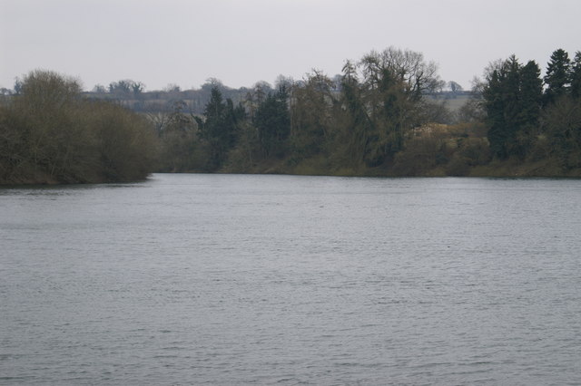
Upper Litton Reservoir 29 ha
Plan your visit
🦅 Birds🦉 Wildlife🐶 Dogs
Public access Free entry Dogs welcome 29 ha
Places › England › South West › Bath and North East Somerset Getting here
51.29420, -2.58682
Open directionsv Visiting this summer
Seasonal nature notes and what to look for now
▾ 🐦 63+ species recorded in this area — summer evenings are best for activity; watch for Shoveler and Black-tailed Godwit 🐕 Early mornings are best for dog walks in summer — visit before 9am to avoid the heat and find quieter trails 🅿️ Parking 364m away — 2 car parks within reach 🌤️ Visiting this summer
🐦 63+ species recorded in this area — summer evenings are best for activity; watch for Shoveler and Black-tailed Godwit 🐕 Early mornings are best for dog walks in summer — visit before 9am to avoid the heat and find quieter trails 🅿️ Parking 364m away — 2 car parks within reach £ Free to visit — no entry charge🐕 Dogs welcome🦅 Bird watching
Very strong match
Birds — Shoveler, Black-tailed Godwit, Pochard +60 more · last seen 2026; Birds — Shoveler, Black-tailed Godwit, Pochard +60 more · last seen 2026
Free
🦉 Wildlife
Very strong match
Multi-group wildlife — Amphibians, Birds; Multi-group wildlife — Amphibians, Birds
Free
Dogs allowed with public access
Free
🦋 Insect spotting
Good match
Insects — Willow Emerald Damselfly, Hornet Hoverfly, Dock Bug +2 more · last seen 2025; Insects — Willow Emerald Damselfly, Hornet Hoverfly, Dock Bug +2 more · last seen 2025
Free
🍄 Mushroom foraging
Good match
Fungi — Pinkedge Bonnet, False Chanterelle · last seen 2025; Fungi — Pinkedge Bonnet, False Chanterelle · last seen 2025
Varies
〰 Waterside walks
Good match
Reservoir — waterside public access
Varies
Trails nearby Within roughly 5 km 6 signed routes nearby · 38 public paths nearby
Signed route nearby Public paths
Monarch's Way Walking route 990 km ▾
approximate route of Charles II's escape
Named route Ref MW Length 990 km Regional walking route
Show on map Samaritans Way South West Walking route 166 km ▾
Named route Length 166 km Regional walking route
Show on map The Butcombe Trail Walking route 74 km ▾
Named route Ref BUT Length 74 km Regional walking route
Show on map The Mendip Trail Walking route ▾
Named route Ref MT Regional walking route
Show on map Three Peaks Walk Walking route 27 km ▾
Named route Length 27 km Round trip Local walking route
Show on map 4 signed routes nearby
Signed route nearby
Route 3 Cycling route 527.7 km ▾
Named route Ref 3 Length 527.7 km National Cycle Network
Show on map EuroVelo 1 - Atlantic Coast Route - part United Kingdom 2 Cycling route ▾
Named route Ref EV1 International cycle route
Show on map Main Route Cycling route 5.5 km ▾
Named route Ref 3 Length 5.5 km National Cycle Network On-road Surface asphalt
Show on map Main Route Cycling route 2.4 km ▾
Named route Ref 3 Length 2.4 km National Cycle Network Traffic-free Surface asphalt
Show on map 2 public paths nearby
Public paths
Hollow Marsh Lane bridleway · 2.6 km ▾
Public path bridleway Length 2.6 km Surface dirt Path type: track
Show on map Stoneyard Lane restricted byway · 968 m ▾
Public path restricted byway Length 968 m Path type: track
Show on map
Weather for this location Next 14 days Nearby places Useful places within 5 km
All Historic
Own or manage this place?
Claim this listing to keep details accurate, add photos, and highlight what makes it special — free.
Claim this page→ How useful was the information on this page?
id: 252f9506-fd93-49d8-a24e-c270005304d3
UK green spaces mapped from open public data — so anyone can find the woodland, trail, or nature reserve closest to them.
© 2026 Glade · Made with care for UK green spaces
Wildlife to spot
37,936 records · National Biodiversity Network
▾
Wildlife to spot 37,936 records · National Biodiversity Network 🐦 Birds 25 species
autumn winter
2026 ▾
Shoveler · Black-tailed Godwit · Pochard · Pintail · Wigeon +20
Shoveler Spatula clypeata Black-tailed Godwit Limosa limosa2025 Pochard Aythya ferina2025 Pintail Anas acuta2025 Wigeon Mareca penelope2025 Mediterranean Gull Ichthyaetus melanocephalus2025 Ruff Calidris pugnax2025 Pheasant Phasianus colchicus2025 Magpie Pica pica2025 Carrion Crow Corvus corone2025 Jackdaw Coloeus monedula2025 Woodpigeon Columba palumbus2025 Pied Wagtail Motacilla alba2025 Starling Sturnus vulgaris2025 Rook Corvus frugilegus2025 Fieldfare Turdus pilaris2025 Lesser Black-backed Gull Larus fuscus2025 Robin Erithacus rubecula2025 Merlin Falco columbarius2025 Little Grebe Tachybaptus ruficollis2025 Mallard Anas platyrhynchos2025 Tufted Duck Aythya fuligula2025 Moorhen Gallinula chloropus2025 Mute Swan Cygnus olor2025 Egyptian Goose Alopochen aegyptiaca2025 Pimple Pinkgill · Oily Waxcap · Ivory Bonnet · Deceiver · Turkeytail +71
Pimple Pinkgill Entoloma hebes Oily Waxcap Hygrocybe quieta Ivory Bonnet Atheniella flavoalba Deceiver Laccaria laccata Turkeytail Trametes versicolor Dung Roundhead Stropharia semiglobata White Fibrecap Inocybe geophylla Broad Buckler-fern · Common Ragwort · Sweet Chestnut · Pendulous Sedge · Crab Apple +14
Broad Buckler-fern Dryopteris dilatata Common Ragwort Jacobaea vulgaris Sweet Chestnut Castanea sativa Pendulous Sedge Carex pendula Crab Apple Malus sylvestris Alexanders Smyrnium olusatrum Dove's-foot Crane's-bill Geranium molle Species observations from the last 10 years via NBN Atlas
Variable Oysterling Crepidotus variabilis
Variable Oysterling Crepidotus variabilis
Wrinkled Crust Phlebia radiata
Wrinkled Crust Phlebia radiata
Scarlet Waxcap Hygrocybe coccinea
Scarlet Waxcap Hygrocybe coccinea
White Saddle Helvella crispa
White Saddle Helvella crispa
Purplepore Bracket Trichaptum abietinum
Purplepore Bracket Trichaptum abietinum
Cowpat Gem Cheilymenia granulata
Cowpat Gem Cheilymenia granulata
Small Stagshorn Calocera cornea
Small Stagshorn Calocera cornea
Yellow Brain Tremella mesenterica
Yellow Brain Tremella mesenterica
Deer Shield Pluteus cervinus
Deer Shield Pluteus cervinus
Golden Waxcap Hygrocybe chlorophana
Golden Waxcap Hygrocybe chlorophana
Common Jelly Spot Dacrymyces stillatus
Common Jelly Spot Dacrymyces stillatus
Cortinarius helvolus Cortinarius helvolus
Cortinarius helvolus Cortinarius helvolus
Spangle Waxcap Hygrocybe insipida
Spangle Waxcap Hygrocybe insipida
Elastic Saddle Helvella elastica
Elastic Saddle Helvella elastica
Apricot Club Clavulinopsis luteoalba
Apricot Club Clavulinopsis luteoalba
Beechleaf Parachute Rhizomarasmius setosus
Beechleaf Parachute Rhizomarasmius setosus
Peeling Oysterling Crepidotus mollis
Peeling Oysterling Crepidotus mollis
Snowy Inkcap Coprinopsis nivea
Snowy Inkcap Coprinopsis nivea
Witch's Butter Exidia glandulosa
Witch's Butter Exidia glandulosa
Goldleaf Shield Pluteus romellii
Goldleaf Shield Pluteus romellii
Hare'sfoot Inkcap Coprinopsis lagopus
Hare'sfoot Inkcap Coprinopsis lagopus
Parrot Waxcap Gliophorus psittacinus
Parrot Waxcap Gliophorus psittacinus
Candlesnuff Fungus Xylaria hypoxylon
Candlesnuff Fungus Xylaria hypoxylon
Yellowleg Bonnet Mycena epipterygia
Yellowleg Bonnet Mycena epipterygia
Funeral Bell Galerina marginata
Funeral Bell Galerina marginata
Sticky Scalycap Pholiota gummosa
Sticky Scalycap Pholiota gummosa
Crystal Brain Exidia nucleata
Crystal Brain Exidia nucleata
Twotone Funnel Clitocybe metachroa
Twotone Funnel Clitocybe metachroa
Blackening Waxcap Hygrocybe conica
Blackening Waxcap Hygrocybe conica
Conifer Shield Pluteus pouzarianus
Conifer Shield Pluteus pouzarianus
Butter Cap Rhodocollybia butyracea
Butter Cap Rhodocollybia butyracea
Lilac Fibrecap Inocybe lilacina
Lilac Fibrecap Inocybe lilacina
Snowy Waxcap Cuphophyllus virgineus var. virgineus
Snowy Waxcap Cuphophyllus virgineus var. virgineus
Wood Blewits Lepista nuda
Wood Blewits Lepista nuda
Magic Mushroom Psilocybe semilanceata
Magic Mushroom Psilocybe semilanceata
Twig Parachute Marasmiellus ramealis
Twig Parachute Marasmiellus ramealis
Yellow Stagshorn Calocera viscosa
Yellow Stagshorn Calocera viscosa
King Alfred's Cakes Daldinia concentrica
King Alfred's Cakes Daldinia concentrica
Fleecy Fibrecap Inocybe flocculosa
Fleecy Fibrecap Inocybe flocculosa
Dog Stinkhorn Mutinus caninus
Dog Stinkhorn Mutinus caninus
Angel's Bonnet Mycena arcangeliana
Angel's Bonnet Mycena arcangeliana
Meadow Waxcap Cuphophyllus pratensis var. pratensis
Meadow Waxcap Cuphophyllus pratensis var. pratensis
Shaggy Scalycap Pholiota squarrosa
Shaggy Scalycap Pholiota squarrosa
Fool's Funnel Clitocybe rivulosa
Fool's Funnel Clitocybe rivulosa
Brownedge Bonnet Mycena olivaceomarginata
Brownedge Bonnet Mycena olivaceomarginata
Common Bonnet Mycena galericulata
Common Bonnet Mycena galericulata
Brithdegyll Eddîog Panaeolus papilionaceus
Brithdegyll Eddîog Panaeolus papilionaceus
Volvariella murinella Volvariella murinella
Volvariella murinella Volvariella murinella
Mycena erubescens Mycena erubescens
Mycena erubescens Mycena erubescens
Grooved Bonnet Mycena polygramma
Grooved Bonnet Mycena polygramma
Crepidotus calolepis Crepidotus calolepis
Crepidotus calolepis Crepidotus calolepis
Blushing Rosette Abortiporus biennis
Blushing Rosette Abortiporus biennis
Naematelia aurantia Naematelia aurantia
Naematelia aurantia Naematelia aurantia
Cedarwood Waxcap Cuphophyllus russocoriaceus
Cedarwood Waxcap Cuphophyllus russocoriaceus
Hairy Curtain Crust Stereum hirsutum
Hairy Curtain Crust Stereum hirsutum
Madarch y Maes Agaricus campestris
Madarch y Maes Agaricus campestris
Birch Mazegill Trametes betulina
Birch Mazegill Trametes betulina
Tan Ear Otidea alutacea
Tan Ear Otidea alutacea
Conifer Blueing Bracket Postia caesia
Conifer Blueing Bracket Postia caesia
Cortinarius umbrinolens Cortinarius umbrinolens
Cortinarius umbrinolens Cortinarius umbrinolens
Tawny Funnel Paralepista flaccida
Tawny Funnel Paralepista flaccida
Scaly Earthball Scleroderma verrucosum
Scaly Earthball Scleroderma verrucosum
Fairy Inkcap Coprinellus disseminatus
Fairy Inkcap Coprinellus disseminatus
Dewdrop Mottlegill Panaeolus acuminatus
Dewdrop Mottlegill Panaeolus acuminatus
Grey Coral Clavulina cinerea
Grey Coral Clavulina cinerea
Coldfoot Bonnet Mycena amicta
Coldfoot Bonnet Mycena amicta
Torth Felen Hypholoma fasciculare
Torth Felen Hypholoma fasciculare
Blue Roundhead Stropharia caerulea
Blue Roundhead Stropharia caerulea
Glistening Inkcap Coprinellus micaceus
Glistening Inkcap Coprinellus micaceus
Dryopteris affinis Dryopteris affinis
Dryopteris affinis Dryopteris affinis
Beech Fagus sylvatica
Beech Fagus sylvatica
Bog Stitchwort Stellaria alsine
Bog Stitchwort Stellaria alsine
Hairy St John's-wort Hypericum hirsutum
Hairy St John's-wort Hypericum hirsutum
Three-nerved Sandwort Moehringia trinervia
Three-nerved Sandwort Moehringia trinervia
Shining Crane's-bill Geranium lucidum
Shining Crane's-bill Geranium lucidum
Cherry Laurel Prunus laurocerasus
Cherry Laurel Prunus laurocerasus
Smooth Sow-thistle Sonchus oleraceus
Smooth Sow-thistle Sonchus oleraceus
Groundsel Senecio vulgaris
Groundsel Senecio vulgaris
Woodruff Galium odoratum
Woodruff Galium odoratum
Tall Fescue Schedonorus arundinaceus
Tall Fescue Schedonorus arundinaceus
Grey Sedge Carex divulsa subsp. divulsa
Grey Sedge Carex divulsa subsp. divulsa Events & activities nearby Switch provider to compare local events, tours and bookable activities.
Bookable tours GetYourGuide Promote here