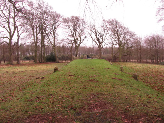
Wayland's Smithy chambered long barrow, including an earlier barrow and Iron Age and Roman boundary ditches 0 ha
🦉 Wildlife🦅 Birds🦋 Insects
↑ Share
Free entry Dogs welcome 0 ha
Places › England › South East › Vale of White Horse Getting here
51.56675, -1.59610
Open directionsv ✦ Scheduled Ancient Monument — Nationally protected archaeological site on the National Heritage List for England (NHLE). Scheduled monuments represent the best surviving examples of England's irreplaceable archaeological heritage.
Archaeological site scheduled monument
Visiting this summer
Seasonal nature notes and what to look for now
▾ 🌞 Midsummer — early morning visits most comfortable; look for deer fawns in quieter clearings ✦ Historic character is a year-round quality here — summer brings its own atmosphere to the setting 🐕 Dogs welcome — bring water in summer; the site has enough space to find shade on hot days 🌤️ Visiting this summer
🌞 Midsummer — early morning visits most comfortable; look for deer fawns in quieter clearings ✦ Historic character is a year-round quality here — summer brings its own atmosphere to the setting 🐕 Dogs welcome — bring water in summer; the site has enough space to find shade on hot days £ Free to visit — no entry charge🐕 Dogs welcome🦉 Wildlife
Very strong match
Multi-group wildlife — Birds, Mammals, Reptiles; Multi-group wildlife — Birds, Mammals, Reptiles
Free
🦅 Bird watching
Very strong match
Birds — Chaffinch, Woodpigeon, Skylark +65 more · last seen 2025; Birds — Chaffinch, Woodpigeon, Skylark +65 more · last seen 2025
Free
🦋 Insect spotting
Strong match
Insects — Large Yellow Underwing, Brimstone Moth, Common Wainscot +215 more · last seen 2025; Insects — Large Yellow Underwing, Brimstone Moth, Common Wainscot +215 more · last seen 2025
Free
Deciduous woodland — fungi, berries and wild garlic
Varies
Trails nearby Within roughly 5 km 7 signed routes nearby
Signed route nearby
The Ridgeway Walking route 140 km ▾
Named route Ref RW Length 140 km National walking route
Show on map D'Arcy Dalton Way Walking route 107 km ▾
Follows roughly the western boundary of Oxfordshire in unspoilt countryside.
Named route Length 107 km Regional walking route
Show on map The Roman Way Walking route 274.5 km ▾
Named route Length 274.5 km Regional walking route
Show on map White horse circular walk Walking route ▾
Named route Ref WHCW Local walking route
Show on map Lambourn Valley Way Walking route ▾
Named route Local walking route
Show on map 1 signed route nearby
Signed route nearby
Vale Cycle Links Cycling route ▾
1 signed route nearby
Signed route nearby
King Alfred's Way Mountain bike route ▾
King Alfreds Way is 350km (220 miles) off road route designed to be ridden clockwise. It starts & ends in Winchester. It is suitable for gravel or cross-country bikes.
Named route Regional cycle route
Show on map 9 public paths nearby
Public paths
The Ridgeway restricted byway · 215 m ▾
Public path restricted byway Length 215 m Surface compacted Path type: track
Show on map The Ridgeway restricted byway · 312 m ▾
Public path restricted byway Length 312 m Surface dirt Path type: track
Show on map The Ridgeway restricted byway · 277 m ▾
Public path restricted byway Length 277 m Surface dirt Path type: track
Show on map The Ridgeway restricted byway · 127 m ▾
Public path restricted byway Length 127 m Surface compacted Path type: track
Show on map The Ridgeway restricted byway · 247 m ▾
Public path restricted byway Length 247 m Surface compacted Incline down Path type: track
Show on map Photos Wayland's Smithy Long Barrow
‹ ›
Weather for this location Next 14 days Nearby places Useful places within 5 km
All Historic
Own or manage this place?
Claim this listing to keep details accurate, add photos, and highlight what makes it special — free.
Claim this page→ How useful was the information on this page?
Something wrong on this page?
id: 2204980a-fffe-4ace-b653-458040d8ebed
UK green spaces mapped from open public data — so anyone can find the woodland, trail, or nature reserve closest to them.
© 2026 Glade · Made with care for UK green spaces
White-point
White-point
Mythimna albipuncta2023
Mythimna albipuncta2023
Burnished Brass Diachrysia chrysitis
Burnished Brass Diachrysia chrysitis
Angle Shades Phlogophora meticulosa
Angle Shades Phlogophora meticulosa
Spectacle Abrostola tripartita
Spectacle Abrostola tripartita
Flounced Rustic Luperina testacea2023
Flounced Rustic Luperina testacea2023
Dusky Thorn Ennomos fuscantaria
Dusky Thorn Ennomos fuscantaria
Shuttle-shaped Dart Agrotis puta
Shuttle-shaped Dart Agrotis puta
Vine's Rustic Hoplodrina ambigua2023
Vine's Rustic Hoplodrina ambigua2023
Flame Shoulder Ochropleura plecta2023
Flame Shoulder Ochropleura plecta2023
Swallow Prominent Pheosia tremula2023
Swallow Prominent Pheosia tremula2023
Common Rustic agg. Mesapamea secalis agg.
Common Rustic agg. Mesapamea secalis agg.
Dusky Sallow Eremobia ochroleuca
Dusky Sallow Eremobia ochroleuca
Rosy Rustic Hydraecia micacea2023
Rosy Rustic Hydraecia micacea2023
Poplar Hawk-moth Laothoe populi2023
Poplar Hawk-moth Laothoe populi2023
Elephant Hawk-moth Deilephila elpenor
Elephant Hawk-moth Deilephila elpenor
Ruby Tiger Phragmatobia fuliginosa
Ruby Tiger Phragmatobia fuliginosa
Lime-speck Pug Eupithecia centaureata
Lime-speck Pug Eupithecia centaureata
Square-spot Rustic Xestia xanthographa2023
Square-spot Rustic Xestia xanthographa2023
Orange Swift Triodia sylvina2023
Orange Swift Triodia sylvina2023
Least Carpet Idaea rusticata
Least Carpet Idaea rusticata
Box Tree Moth Cydalima perspectalis
Box Tree Moth Cydalima perspectalis
Mother of Pearl Patania ruralis
Mother of Pearl Patania ruralis
Heart & Dart Agrotis exclamationis
Heart & Dart Agrotis exclamationis
Silver Y Autographa gamma2023
Silver Y Autographa gamma2023
Broad-bordered Yellow Underwing Noctua fimbriata2023
Broad-bordered Yellow Underwing Noctua fimbriata2023
Dingy Footman Eilema griseola2023
Dingy Footman Eilema griseola2023
Gold Spot Plusia festucae2023
Gold Spot Plusia festucae2023
Lesser Broad-bordered Yellow Underwing Noctua janthe2023
Lesser Broad-bordered Yellow Underwing Noctua janthe2023
Nut-tree Tussock Colocasia coryli
Nut-tree Tussock Colocasia coryli
Flame Axylia putris
Flame Axylia putris
Riband Wave Idaea aversata
Riband Wave Idaea aversata
Pale Prominent Pterostoma palpina
Pale Prominent Pterostoma palpina
Canary-shouldered Thorn Ennomos alniaria
Canary-shouldered Thorn Ennomos alniaria
Hebrew Character Orthosia gothica
Hebrew Character Orthosia gothica
Black Rustic Aporophyla nigra2023
Black Rustic Aporophyla nigra2023
Beaded Chestnut Agrochola lychnidis2023
Beaded Chestnut Agrochola lychnidis2023
Red Underwing Catocala nupta2023
Red Underwing Catocala nupta2023
Lunar Underwing Anchoscelis lunosa2023
Lunar Underwing Anchoscelis lunosa2023
Snout Hypena proboscidalis2023
Snout Hypena proboscidalis2023
Green Carpet Colostygia pectinataria2023
Green Carpet Colostygia pectinataria2023
Chinese Character Cilix glaucata2023
Chinese Character Cilix glaucata2023
Turnip Moth Agrotis segetum2023
Turnip Moth Agrotis segetum2023
September Thorn Ennomos erosaria2023
September Thorn Ennomos erosaria2023
Small Square-spot Diarsia rubi2023
Small Square-spot Diarsia rubi2023
Bright-line Brown-eye Lacanobia oleracea2023
Bright-line Brown-eye Lacanobia oleracea2023
Buckthorn Dot Stigmella catharticella
Buckthorn Dot Stigmella catharticella
Red/Dark-barred Twin-spot Carpet Xanthorhoe spadicearia/ferrugata
Red/Dark-barred Twin-spot Carpet Xanthorhoe spadicearia/ferrugata
Old Lady Mormo maura
Old Lady Mormo maura
Common Footman Eilema lurideola
Common Footman Eilema lurideola
Small Elephant Hawk-moth Deilephila porcellus
Small Elephant Hawk-moth Deilephila porcellus
Dark Arches Apamea monoglypha
Dark Arches Apamea monoglypha
Peppered Moth Biston betularia
Peppered Moth Biston betularia
Green-brindled Crescent Allophyes oxyacanthae2023
Green-brindled Crescent Allophyes oxyacanthae2023
Delicate Mythimna vitellina2023
Delicate Mythimna vitellina2023
Common Marbled Carpet Dysstroma truncata2023
Common Marbled Carpet Dysstroma truncata2023
Copper Underwing agg. Amphipyra pyramidea agg.2023
Copper Underwing agg. Amphipyra pyramidea agg.2023
Centre-barred Sallow Atethmia centrago2023
Centre-barred Sallow Atethmia centrago2023
Single-dotted Wave Idaea dimidiata2023
Single-dotted Wave Idaea dimidiata2023
Straw Underwing Thalpophila matura2023
Straw Underwing Thalpophila matura2023
Marbled Minor agg. Oligia strigilis agg.2023
Marbled Minor agg. Oligia strigilis agg.2023
Buff Ermine Spilosoma lutea2023
Buff Ermine Spilosoma lutea2023
Light Emerald Campaea margaritaria2022
Light Emerald Campaea margaritaria2022
Oak Hook-tip Watsonalla binaria2022
Oak Hook-tip Watsonalla binaria2022
Maple Dot Stigmella aceris
Maple Dot Stigmella aceris
Small Beech Dot Stigmella tityrella
Small Beech Dot Stigmella tityrella
Apple Leaf Miner Lyonetia clerkella
Apple Leaf Miner Lyonetia clerkella
Swallow-tailed Moth Ourapteryx sambucaria
Swallow-tailed Moth Ourapteryx sambucaria
Yellow-tail Euproctis similis
Yellow-tail Euproctis similis
Clouded Border Lomaspilis marginata
Clouded Border Lomaspilis marginata
Barred Straw Gandaritis pyraliata
Barred Straw Gandaritis pyraliata
Buff Arches Habrosyne pyritoides
Buff Arches Habrosyne pyritoides
Shark Cucullia umbratica
Shark Cucullia umbratica
Bloody-nosed Beetle Timarcha tenebricosa
Bloody-nosed Beetle Timarcha tenebricosa
Burnet Moth Zygaena
Burnet Moth Zygaena
Burnet Companion Euclidia glyphica
Burnet Companion Euclidia glyphica
Yellow Shell Camptogramma bilineata
Yellow Shell Camptogramma bilineata
Oak Beauty Biston strataria
Oak Beauty Biston strataria
Grey Shoulder-knot Lithophane ornitopus
Grey Shoulder-knot Lithophane ornitopus
Powdered Quaker Orthosia gracilis
Powdered Quaker Orthosia gracilis
Glow-worm Lampyris noctiluca2024
Glow-worm Lampyris noctiluca2024
Red-Line Quaker Leptologia lota2023
Red-Line Quaker Leptologia lota2023
Merveille du Jour Griposia aprilina2023
Merveille du Jour Griposia aprilina2023
Barred Sallow Tiliacea aurago2023
Barred Sallow Tiliacea aurago2023
Gypsy Moth Lymantria dispar2023
Gypsy Moth Lymantria dispar2023
Common Wave Cabera exanthemata2023
Common Wave Cabera exanthemata2023
Magpie Moth Abraxas grossulariata2023
Magpie Moth Abraxas grossulariata2023
Shoulder-striped Wainscot Leucania comma2023
Shoulder-striped Wainscot Leucania comma2023
Mouse Moth Amphipyra tragopoginis2023
Mouse Moth Amphipyra tragopoginis2023
Blood-vein Timandra comae2023
Blood-vein Timandra comae2023
Beautiful Hook-tip Laspeyria flexula2023
Beautiful Hook-tip Laspeyria flexula2023
Pebble Hook-tip Drepana falcataria2023
Pebble Hook-tip Drepana falcataria2023
White Ermine Spilosoma lubricipeda2023
White Ermine Spilosoma lubricipeda2023
Drinker Euthrix potatoria2023
Drinker Euthrix potatoria2023
Lychnis Hadena bicruris2023
Lychnis Hadena bicruris2023
Rustic Shoulder-knot Apamea sordens2023
Rustic Shoulder-knot Apamea sordens2023
Pale Tussock Calliteara pudibunda2023
Pale Tussock Calliteara pudibunda2023
Treble Lines Charanyca trigrammica2023
Treble Lines Charanyca trigrammica2023
Cinnabar Tyria jacobaeae2023
Cinnabar Tyria jacobaeae2023
Bee Moth Aphomia sociella2023
Bee Moth Aphomia sociella2023
Waved Umber Menophra abruptaria2023
Waved Umber Menophra abruptaria2023
Golden Dot Stigmella aurella2023
Golden Dot Stigmella aurella2023
Scarce Footman Eilema complana2022
Scarce Footman Eilema complana2022
Lunar Hornet Moth Sesia bembeciformis2022
Lunar Hornet Moth Sesia bembeciformis2022
Dogwood Cutter Antispila petryi
Dogwood Cutter Antispila petryi
Maple Leaf-miner Phyllonorycter acerifoliella
Maple Leaf-miner Phyllonorycter acerifoliella
Buckthorn Tuft Bucculatrix frangutella
Buckthorn Tuft Bucculatrix frangutella
Ilex Leaf-miner Phyllonorycter messaniella
Ilex Leaf-miner Phyllonorycter messaniella
Barred Fruit-tree Dot Ectoedemia atricollis
Barred Fruit-tree Dot Ectoedemia atricollis
Apple Nymph Callisto denticulella
Apple Nymph Callisto denticulella
Hawthorn Parornix Parornix anglicella
Hawthorn Parornix Parornix anglicella
Beech Dot Stigmella hemargyrella
Beech Dot Stigmella hemargyrella
Apple Pygmy Stigmella malella
Apple Pygmy Stigmella malella
Buckthorn Case-bearer Coleophora ahenella
Buckthorn Case-bearer Coleophora ahenella
Common Thorn Leaf-miner Phyllonorycter oxyacanthae
Common Thorn Leaf-miner Phyllonorycter oxyacanthae
Blue-shot Dot Stigmella plagicolella
Blue-shot Dot Stigmella plagicolella
Rhamphus oxyacanthae Rhamphus oxyacanthae
Rhamphus oxyacanthae Rhamphus oxyacanthae
Beech Leaf-miner Phyllonorycter maestingella
Beech Leaf-miner Phyllonorycter maestingella
European Corn-borer Ostrinia nubilalis
European Corn-borer Ostrinia nubilalis
Plain Golden Y Autographa jota
Plain Golden Y Autographa jota
Common Emerald Hemithea aestivaria
Common Emerald Hemithea aestivaria
Peach Blossom Thyatira batis
Peach Blossom Thyatira batis
Small Blood-vein Scopula imitaria
Small Blood-vein Scopula imitaria
Lappet Gastropacha quercifolia
Lappet Gastropacha quercifolia
Mother Shipton Callistege mi
Mother Shipton Callistege mi
Clouded Drab Orthosia incerta
Clouded Drab Orthosia incerta
Small Quaker Orthosia cruda
Small Quaker Orthosia cruda
Summer Chafer Amphimallon solstitiale2024
Summer Chafer Amphimallon solstitiale2024
Swan-feather Dwarf Elachista argentella2024
Swan-feather Dwarf Elachista argentella2024
Five-spot Burnet Zygaena trifolii2024
Five-spot Burnet Zygaena trifolii2024
Rock-rose Mompha Mompha miscella2024
Rock-rose Mompha Mompha miscella2024
Sainfoin Piercer Grapholita caecana2024
Sainfoin Piercer Grapholita caecana2024
Meadow Tortrix Grapholita compositella2024
Meadow Tortrix Grapholita compositella2024
Common Cockchafer Melolontha melolontha2024
Common Cockchafer Melolontha melolontha2024
Platycheirus albimanus Platycheirus albimanus2024
Platycheirus albimanus Platycheirus albimanus2024
Eristalis pertinax Eristalis pertinax2024
Eristalis pertinax Eristalis pertinax2024
Marmalade Hoverfly Episyrphus balteatus2024
Marmalade Hoverfly Episyrphus balteatus2024
Platycheirus scutatus Platycheirus scutatus2024
Platycheirus scutatus Platycheirus scutatus2024
Cabbage Bug Eurydema (Eurydema) oleracea2024
Cabbage Bug Eurydema (Eurydema) oleracea2024
Melanostoma scalare Melanostoma scalare2024
Melanostoma scalare Melanostoma scalare2024
Winter Moth Operophtera brumata2024
Winter Moth Operophtera brumata2024
Feathered Thorn Colotois pennaria2023
Feathered Thorn Colotois pennaria2023
December Moth Poecilocampa populi2023
December Moth Poecilocampa populi2023
Humming-bird Hawk-moth Macroglossum stellatarum2023
Humming-bird Hawk-moth Macroglossum stellatarum2023
Chestnut Conistra vaccinii2023
Chestnut Conistra vaccinii2023
Yellow-Line Quaker Leptologia macilenta2023
Yellow-Line Quaker Leptologia macilenta2023
Eristalis tenax Eristalis tenax2023
Eristalis tenax Eristalis tenax2023
Blair's Shoulder-knot Lithophane leautieri2023
Blair's Shoulder-knot Lithophane leautieri2023
Ivy Bee Colletes hederae2023
Ivy Bee Colletes hederae2023
Jersey Tiger Euplagia quadripunctaria2023
Jersey Tiger Euplagia quadripunctaria2023
Copper Underwing Amphipyra pyramidea2023
Copper Underwing Amphipyra pyramidea2023
Coronet Craniophora ligustri2023
Coronet Craniophora ligustri2023
Shaded Broad-bar Scotopteryx chenopodiata2023
Shaded Broad-bar Scotopteryx chenopodiata2023
Cypress Pug Eupithecia phoeniceata2023
Cypress Pug Eupithecia phoeniceata2023
Yellow-barred Brindle Acasis viretata2023
Yellow-barred Brindle Acasis viretata2023
Dun-bar Cosmia trapezina2023
Dun-bar Cosmia trapezina2023
Toxonevra muliebris Toxonevra muliebris2023
Toxonevra muliebris Toxonevra muliebris2023
Grey/Dark Dagger Acronicta psi/tridens2023
Grey/Dark Dagger Acronicta psi/tridens2023
Black Arches Lymantria monacha2023
Black Arches Lymantria monacha2023
Brown-line Bright-eye Mythimna conigera2023
Brown-line Bright-eye Mythimna conigera2023
Lesser Yellow Underwing Noctua comes2023
Lesser Yellow Underwing Noctua comes2023
Banded General Stratiomys potamida2023
Banded General Stratiomys potamida2023
Six-spot Burnet Zygaena filipendulae2023
Six-spot Burnet Zygaena filipendulae2023
Clouded Silver Lomographa temerata2023
Clouded Silver Lomographa temerata2023
Scarlet Tiger Callimorpha dominula2023
Scarlet Tiger Callimorpha dominula2023
Cypress Carpet Thera cupressata2023
Cypress Carpet Thera cupressata2023
Light Arches Apamea lithoxylaea2023
Light Arches Apamea lithoxylaea2023
Small Magpie Anania hortulata2023
Small Magpie Anania hortulata2023
Sharp-angled Peacock Macaria alternata2023
Sharp-angled Peacock Macaria alternata2023
Common Swift Korscheltellus lupulina2023
Common Swift Korscheltellus lupulina2023
Poplar Grey Subacronicta megacephala2023
Poplar Grey Subacronicta megacephala2023
Green Oak Tortrix Tortrix viridana2023
Green Oak Tortrix Tortrix viridana2023
Garden Carpet Xanthorhoe fluctuata2023
Garden Carpet Xanthorhoe fluctuata2023
Privet Hawk-moth Sphinx ligustri2023
Privet Hawk-moth Sphinx ligustri2023
Scorched Wing Plagodis dolabraria2023
Scorched Wing Plagodis dolabraria2023
Sandy Carpet Perizoma flavofasciata2023
Sandy Carpet Perizoma flavofasciata2023
Shears Hada plebeja2023
Shears Hada plebeja2023
Puss Moth Cerura vinula2023
Puss Moth Cerura vinula2023
Maiden's Blush Cyclophora punctaria2023
Maiden's Blush Cyclophora punctaria2023
Chocolate-tip Clostera curtula2023
Chocolate-tip Clostera curtula2023
Mullein Cucullia verbasci2023
Mullein Cucullia verbasci2023
Herald Scoliopteryx libatrix2023
Herald Scoliopteryx libatrix2023
Red-green Carpet Chloroclysta siterata2023
Red-green Carpet Chloroclysta siterata2023
Frosted Green Polyploca ridens2023
Frosted Green Polyploca ridens2023
Brindled Beauty Lycia hirtaria2023
Brindled Beauty Lycia hirtaria2023
Black Oil-beetle Meloe proscarabaeus2023
Black Oil-beetle Meloe proscarabaeus2023
Brown-Spot Pinion Anchoscelis litura2022
Brown-Spot Pinion Anchoscelis litura2022
Deep-brown Dart Aporophyla lueneburgensis2022
Deep-brown Dart Aporophyla lueneburgensis2022
Brindled Green Dryobotodes eremita2022
Brindled Green Dryobotodes eremita2022
Convolvulus Hawk-moth Agrius convolvuli2022
Convolvulus Hawk-moth Agrius convolvuli2022
Vestal Rhodometra sacraria2022
Vestal Rhodometra sacraria2022
Feathered Gothic Tholera decimalis2022
Feathered Gothic Tholera decimalis2022
Pearly Underwing Peridroma saucia2022
Pearly Underwing Peridroma saucia2022
Common Carpet Epirrhoe alternata2022
Common Carpet Epirrhoe alternata2022
Purple Bar Cosmorhoe ocellata2022
Purple Bar Cosmorhoe ocellata2022
Leopard Moth Zeuzera pyrina2022
Leopard Moth Zeuzera pyrina2022
August Thorn Ennomos quercinaria2022
August Thorn Ennomos quercinaria2022
White-foot Moth Epiblema foenella2022
White-foot Moth Epiblema foenella2022
Cloaked Minor Mesoligia furuncula2022
Cloaked Minor Mesoligia furuncula2022
Pebble Prominent Notodonta ziczac2022
Pebble Prominent Notodonta ziczac2022
Bordered Sallow Pyrrhia umbra2022
Bordered Sallow Pyrrhia umbra2022
Uncertain/Rustic Hoplodrina octogenaria/blanda2022
Uncertain/Rustic Hoplodrina octogenaria/blanda2022
Knot Grass Acronicta rumicis2022
Knot Grass Acronicta rumicis2022
Scarce Silver-lines Bena bicolorana2022
Scarce Silver-lines Bena bicolorana2022
Small Emerald Hemistola chrysoprasaria2022
Small Emerald Hemistola chrysoprasaria2022
Buff-tip Phalera bucephala2022
Buff-tip Phalera bucephala2022
Fan-foot Herminia tarsipennalis2022
Fan-foot Herminia tarsipennalis2022
Dark Umber Philereme transversata2022
Dark Umber Philereme transversata2022
Double-square Spot Xestia triangulum2022
Double-square Spot Xestia triangulum2022
Red-belted Clearwing Synanthedon myopaeformis2022
Red-belted Clearwing Synanthedon myopaeformis2022 Events & activities nearby Switch provider to compare local events, tours and bookable activities.
Bookable tours GetYourGuide Promote here