Camp Hill Rugby Football Club
Places › England › West Midlands › Solihull Getting here
52.41028, -1.83318
Open directionsv Visiting this summer
Seasonal nature notes and what to look for now
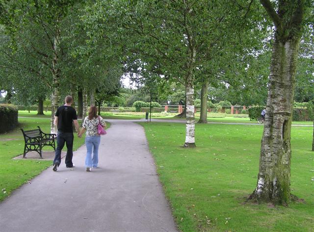
▾ 🌞 Midsummer — early morning visits most comfortable; look for deer fawns in quieter clearings ⚽ Playing fields is at its best in summer here ☕ The Two Mugs — a good base for a longer summer day out 🌤️ Visiting this summer
🌞 Midsummer — early morning visits most comfortable; look for deer fawns in quieter clearings ⚽ Playing fields is at its best in summer here ☕ The Two Mugs — a good base for a longer summer day out 🚲 Bike parking☕ Café🅿️ Parking· Paid
⚽ Playing fields
Very strong match
Playing field
Free
Trails nearby Within roughly 5 km 15 signed routes nearby
Signed route nearby
Grand Union Canal Walk Walking route 234 km ▾
Birmingham to Napton section
Named route Length 234 km Regional walking route
Show on map Balsall Heath Tree Trail East Walking route ▾
Named route Local walking route
Show on map Rail Trail: Widney Manor > Dorridge Walking route 4.4 km ▾
A 2.75-mile easy walk through Solihull’s suburbia and countryside between two stations, crossing the M42 and the river Blythe.
Duration: 1.5 hours
Distance: 2.75 miles
Named route Ref rtWM Length 4.4 km Point-to-point Local walking route
Show on map Rail Trail: Olton > Shirley Walking route 12.5 km ▾
An 8-mile longer meander along the banks of the Grand Union Canal and the River Cole, through the heart of Tolkein Country!
Duration: 3.5 hours
Distance: 8 miles
Named route Ref rtOlt Length 12.5 km Point-to-point Local walking route
Show on map Rail Trail: The Lakes > Earlswood Walking route 6.3 km ▾
A 3-mile trail tranquil and easy route, circumnavigating Earlswood Lakes before heading into the leafy shade of Clowes Wood en-route to Earlswood.
Duration: 2 hours
Distance: 4 miles
Named route Ref rtTLa Length 6.3 km Point-to-point Local walking route
Show on map 9 signed routes nearby
Signed route nearby
Solihull-Knowle Cycling route ▾
Named route Local cycle route
Show on map National Cycle Network Route 5 Cycling route ▾
Named route Ref 5 National Cycle Network
Show on map Cole Valley Route Cycling route ▾
Named route Local cycle route
Show on map Billesley & Shire Country Park Circular Cycling route ▾
Named route Ref 4 Local cycle route
Show on map Rea Valley Route Cycling route ▾
NCN 5 section of Rea Valley Route
Named route Ref Rea Valley
Show on map [PROPOSED]Starley Regional Cycle Network Cycling route 804 km ▾
Starley (TfWM) Regional Cycle Network (Proposed route)
Named route Ref Starley Network Length 804 km Regional cycle route
Show on map
Weather for this location Next 14 days Nearby places Useful places within 5 km
Own or manage this place?
Claim this listing to keep details accurate, add photos, and highlight what makes it special — free.
Claim this page→ How useful was the information on this page?
Something wrong on this page?
id: fa8177a4-560d-43e1-8d8b-eba1bfeccfca
UK green spaces mapped from open public data — so anyone can find the woodland, trail, or nature reserve closest to them.
© 2026 Glade · Made with care for UK green spaces
Events & activities nearby Switch provider to compare local events, tours and bookable activities.
Bookable tours GetYourGuide Promote here
Wildlife to spot
38,250 records · National Biodiversity Network
▾
Wildlife to spot 38,250 records · National Biodiversity Network 🐦 Birds 48 species
spring autumn winter
2026 ▾
Robin · Carrion Crow · Blackbird · Starling · Grey Heron +43
Robin Erithacus rubecula2025 Carrion Crow Corvus corone2025 Blackbird Turdus merula2025 Starling Sturnus vulgaris2025 Grey Heron Ardea cinerea2025 Woodpigeon Columba palumbus2025 Magpie Pica pica2025 Wren Troglodytes troglodytes2025 Tawny Owl Strix aluco2025 Mallard Anas platyrhynchos Jackdaw Coloeus monedula2025 Nuthatch Sitta europaea2025 Song Thrush Turdus philomelos2025 Blue Tit Cyanistes caeruleus2025 Moorhen Gallinula chloropus2025 Raven Corvus corax2025 Great Spotted Woodpecker Dendrocopos major2025 Swift Apus apus2025 Chiffchaff Phylloscopus collybita2025 Great Crested Grebe Podiceps cristatus Greenfinch Chloris chloris Great Tit Parus major2025 Chaffinch Fringilla coelebs2025 Collared Dove Streptopelia decaocto2025 Siskin Spinus spinus2025 Grey Wagtail Motacilla cinerea2025 Coal Tit Periparus ater2025 Canada Goose Branta canadensis2025 Blackcap Sylvia atricapilla2025 Coot Fulica atra Greylag Goose Anser anser Pied Wagtail Motacilla alba yarrellii2025 Goldcrest Regulus regulus2025 Long-tailed Tit Aegithalos caudatus2025 Green Woodpecker Picus viridis2025 Jay Garrulus glandarius2025 Mistle Thrush Turdus viscivorus2025 Kingfisher Alcedo atthis2025 Little Egret Egretta garzetta2025 Goldfinch Carduelis carduelis2025 Black-headed Gull Chroicocephalus ridibundus2025 Rock Dove Columba livia2025 Herring Gull Larus argentatus2025 Cormorant Phalacrocorax carbo2025 Lesser Black-backed Gull Larus fuscus2025 House Sparrow Passer domesticus2025 Dunnock Prunella modularis2025 Stock Dove Columba oenas2025 🦌 Mammals 5 species
summer winter
2025 ▾
Muntjac · Grey Squirrel · Red Fox · Water Shrew · Roe Deer
Muntjac Muntiacus reevesi Grey Squirrel Sciurus carolinensis Red Fox Vulpes vulpes Water Shrew Neomys fodiens Roe Deer Capreolus capreolus Yellow-bellied Slider
Yellow-bellied Slider Trachemys scripta subsp. scripta Parent Bug · 7-spot Ladybird · Hornet Hoverfly · Barberry Fusehorn · Balclutha punctata +40
Parent Bug Elasmucha grisea2025 7-spot Ladybird Coccinella septempunctata Hornet Hoverfly Volucella zonaria2025 Barberry Fusehorn Arge berberidis2025 Balclutha punctata Balclutha punctata2025 Eristalis tenax Eristalis tenax Species observations from the last 10 years via NBN Atlas
2025
2025
Platycheirus albimanus Platycheirus albimanus2025
Platycheirus albimanus Platycheirus albimanus2025
Green Shieldbug Palomena prasina2025
Green Shieldbug Palomena prasina2025
Rhopalus (Rhopalus) subrufus Rhopalus (Rhopalus) subrufus2025
Rhopalus (Rhopalus) subrufus Rhopalus (Rhopalus) subrufus2025
Syritta pipiens Syritta pipiens2025
Syritta pipiens Syritta pipiens2025
Ferdinandea cuprea Ferdinandea cuprea2025
Ferdinandea cuprea Ferdinandea cuprea2025
Corizus hyoscyami Corizus hyoscyami2025
Corizus hyoscyami Corizus hyoscyami2025
Loensia Loensia2025
Loensia Loensia2025
Metoecus paradoxus Metoecus paradoxus2025
Metoecus paradoxus Metoecus paradoxus2025
Field Grasshopper Chorthippus brunneus2025
Field Grasshopper Chorthippus brunneus2025
Volucella inanis Volucella inanis2025
Volucella inanis Volucella inanis2025
Scaeva pyrastri Scaeva pyrastri2025
Scaeva pyrastri Scaeva pyrastri2025
Eupeodes luniger Eupeodes luniger2025
Eupeodes luniger Eupeodes luniger2025
Common Darter Sympetrum striolatum2025
Common Darter Sympetrum striolatum2025
Syrphus Syrphus2025
Syrphus Syrphus2025
10-spot Ladybird Adalia decempunctata2025
10-spot Ladybird Adalia decempunctata2025
Syrphus torvus Syrphus torvus2025
Syrphus torvus Syrphus torvus2025
Cheilosia bergenstammi Cheilosia bergenstammi2025
Cheilosia bergenstammi Cheilosia bergenstammi2025
Oncotylus (Oncotylus) viridiflavus Oncotylus (Oncotylus) viridiflavus2025
Oncotylus (Oncotylus) viridiflavus Oncotylus (Oncotylus) viridiflavus2025
Common Blue Damselfly Enallagma cyathigerum2025
Common Blue Damselfly Enallagma cyathigerum2025
Eupteryx melissae Eupteryx melissae2025
Eupteryx melissae Eupteryx melissae2025
Blue-tailed Damselfly Ischnura elegans2025
Blue-tailed Damselfly Ischnura elegans2025
Welsh Chafer Hoplia philanthus2025
Welsh Chafer Hoplia philanthus2025
Eupteryx decemnotata Eupteryx decemnotata2025
Eupteryx decemnotata Eupteryx decemnotata2025
Rosemary Beetle Chrysolina americana2025
Rosemary Beetle Chrysolina americana2025
Eupteryx aurata Eupteryx aurata2025
Eupteryx aurata Eupteryx aurata2025
Macrosteles Macrosteles2025
Macrosteles Macrosteles2025
Psammotettix Psammotettix2025
Psammotettix Psammotettix2025
2-spot Ladybird Adalia bipunctata2025
2-spot Ladybird Adalia bipunctata2025
Pipizella Pipizella2025
Pipizella Pipizella2025
Broad Centurion Chloromyia formosa2025
Broad Centurion Chloromyia formosa2025
Andromeda Lacebug Stephanitis takeyai2025
Andromeda Lacebug Stephanitis takeyai2025
Closterotomus trivialis Closterotomus trivialis2025
Closterotomus trivialis Closterotomus trivialis2025
Rivellia syngenesiae Rivellia syngenesiae2025
Rivellia syngenesiae Rivellia syngenesiae2025
Meliscaeva auricollis Meliscaeva auricollis2025
Meliscaeva auricollis Meliscaeva auricollis2025
Chrysogaster solstitialis Chrysogaster solstitialis2025
Chrysogaster solstitialis Chrysogaster solstitialis2025
Melanostoma scalare Melanostoma scalare2025
Melanostoma scalare Melanostoma scalare2025
Epistrophe eligans Epistrophe eligans2025
Epistrophe eligans Epistrophe eligans2025
Cheilosia albitarsis Cheilosia albitarsis2025
Cheilosia albitarsis Cheilosia albitarsis2025
Melanostoma Melanostoma2025
Melanostoma Melanostoma2025