Plan your visit
🦉 Wildlife🦅 Birds🍂 Seasonal
Free entry Dogs welcome 0 ha
Places › England › East Midlands › High Peak Getting here
53.32166, -1.80626
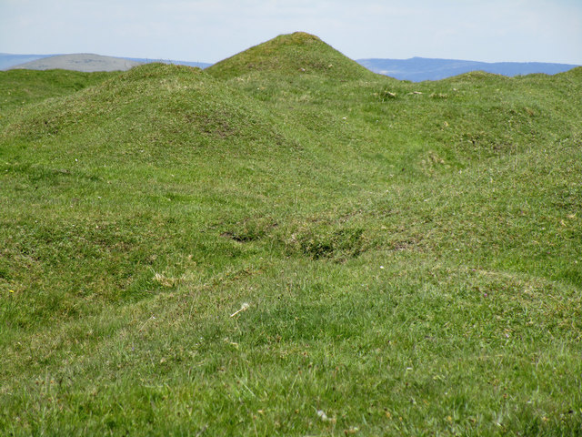
Open directionsv ✦ Scheduled Ancient Monument — Nationally protected archaeological site on the National Heritage List for England (NHLE). Scheduled monuments represent the best surviving examples of England's irreplaceable archaeological heritage.
Tumulus scheduled monument
Visiting this summer
Seasonal nature notes and what to look for now
▾ 🌞 Midsummer — early morning visits most comfortable; look for deer fawns in quieter clearings ✦ Historic character is a year-round quality here — summer brings its own atmosphere to the setting 🐕 Dogs welcome — bring water in summer; the site has enough space to find shade on hot days 🌤️ Visiting this summer
🌞 Midsummer — early morning visits most comfortable; look for deer fawns in quieter clearings ✦ Historic character is a year-round quality here — summer brings its own atmosphere to the setting 🐕 Dogs welcome — bring water in summer; the site has enough space to find shade on hot days £ Free to visit — no entry charge🐕 Dogs welcome🦉 Wildlife
Very strong match
Multi-group wildlife — Amphibians, Birds, Mammals; Multi-group wildlife — Amphibians, Birds, Mammals
Free
🦅 Bird watching
Very strong match
Birds — Goldfinch, Blackbird, Great Tit +51 more · last seen 2026; Birds — Goldfinch, Blackbird, Great Tit +51 more · last seen 2026
Free
🍂 Seasonal nature
Strong match
Plants — Green Spleenwort, Sweet Cicely, Mountain Pansy +33 more · last seen 2025; Plants — Green Spleenwort, Sweet Cicely, Mountain Pansy +33 more · last seen 2025
Free
🦋 Insect spotting
Strong match
Insects — Myrmica scabrinodis, Small Black Ant, Common Green Grasshopper +36 more · last seen 2025; Insects — Myrmica scabrinodis, Small Black Ant, Common Green Grasshopper +36 more · last seen 2025
Free
Plants — Sweet Cicely, Wood-sorrel, Rough Hawkbit
Varies
Trails nearby Within roughly 5 km 9 signed routes nearby
Signed route nearby
Limestone Way Walking route 74 km ▾
Castleton to Rocester
Named route Length 74 km Point-to-point Regional walking route
Show on map Edale Circular Walk, High Peak Walking route 5.4 km ▾
Low level circular walk which includes part of the Pennine Way, following streams and stone-flagged paths. Dogs must be kept on leads.
Named route Length 5.4 km Duration 02:00 Round trip Local walking route
Show on map Mount Famine, South Head and Brown Knoll (Ethels), High Peak Walking route 10.9 km ▾
Named route Length 10.9 km Duration 03:00 Round trip Local walking route
Show on map Peak District Boundary Walk Stage 2 Walking route 15.6 km ▾
Named route Length 15.6 km Regional walking route
Show on map Mam Tor Cavedale Loop, High Peak Walking route 9.5 km ▾
Named route Length 9.5 km Duration 03:30 Round trip Local walking route
Show on map 9 signed routes nearby
Signed route nearby
High Peak Cycleway Cycling route ▾
Named route Local cycle route
Show on map Route 6 Cycling route ▾
Named route Ref 6 National Cycle Network
Show on map Main Route Cycling route 454 m ▾
Named route Ref 6 Length 454 m National Cycle Network On-road Surface asphalt
Show on map Main Route Cycling route 119 m ▾
Named route Ref 6 Length 119 m National Cycle Network On-road Surface asphalt
Show on map Main Route Cycling route 969 m ▾
Named route Ref 6 Length 969 m National Cycle Network On-road Surface asphalt
Show on map Main Route Cycling route 1.2 km ▾
Named route Ref 6 Length 1.2 km National Cycle Network On-road Surface asphalt
Show on map 1 signed route nearby
Signed route nearby
Great North Trail (Peak District and South Pennines) Mountain bike route 130.4 km ▾
Named route Length 130.4 km National Cycle Network
Show on map 3 public paths nearby
Public paths
Oxlow Rake bridleway · 1.2 km ▾
Public path bridleway Length 1.2 km Surface unpaved Path type: track
Show on map
Weather for this location Next 14 days Nearby places Useful places within 5 km
All Historic
Own or manage this place?
Claim this listing to keep details accurate, add photos, and highlight what makes it special — free.
Claim this page→ How useful was the information on this page?
id: aa86d4c7-ea16-4032-bbf7-ae1310803890
UK green spaces mapped from open public data — so anyone can find the woodland, trail, or nature reserve closest to them.
© 2026 Glade · Made with care for UK green spaces
Wildlife to spot
6,453 records · National Biodiversity Network
▾
Wildlife to spot 6,453 records · National Biodiversity Network 🐦 Birds 38 species
spring summer
2026 ▾
Swallow · Willow Warbler · Great Tit · House Martin · Blackbird +33
Swallow Hirundo rustica2025 Willow Warbler Phylloscopus trochilus2025 Great Tit Parus major2025 House Martin Delichon urbicum2025 Blackbird Turdus merula2025 House Sparrow Passer domesticus2025 Collared Dove Streptopelia decaocto2025 Goldfinch Carduelis carduelis2025 Blue Tit Cyanistes caeruleus2025 Greenfinch Chloris chloris2025 Chaffinch Fringilla coelebs2025 Swift Apus apus2025 Garden Warbler Sylvia borin2025 Jackdaw Coloeus monedula2025 Carrion Crow Corvus corone2025 Rook Corvus frugilegus2025 Dunnock Prunella modularis2025 Robin Erithacus rubecula2025 Woodpigeon Columba palumbus2025 Song Thrush Turdus philomelos2025 Mistle Thrush Turdus viscivorus2025 Golden Plover Pluvialis apricaria2025 Linnet Linaria cannabina2025 Wren Troglodytes troglodytes2025 Chiffchaff Phylloscopus collybita2025 Wheatear Oenanthe oenanthe2025 Magpie Pica pica2025 Barn Owl Tyto alba Starling Sturnus vulgaris2025 Black-headed Gull Chroicocephalus ridibundus2025 Lesser Black-backed Gull Larus fuscus2025 Rock Dove Columba livia2025 Raven Corvus corax2025 Whitethroat Curruca communis2025 Great Spotted Woodpecker Dendrocopos major2025 Curlew Numenius arquata2025 Skylark Alauda arvensis2025 Redstart Phoenicurus phoenicurus2025 🦌 Mammals 3 species
summer autumn
2025 ▾
Rabbit · Brown Hare · Hedgehog
Rabbit Oryctolagus cuniculus Brown Hare Lepus europaeus Hedgehog Erinaceus europaeus 🐸 Amphibians 1 species
summer
2025 ▾
Smooth Newt
Smooth Newt Lissotriton vulgaris Small Black Ant · Myrmica scabrinodis · Eristalis tenax · Rhingia campestris · Bibio pomonae +8
Small Black Ant Lasius niger Myrmica scabrinodis Myrmica scabrinodis Eristalis tenax Eristalis tenax Rhingia campestris Rhingia campestris Bibio pomonae Bibio pomonae Formica lemani Formica lemani Mottled Grasshopper Myrmeleotettix maculatus 🌿 Plants 18 species
spring summer
2025 ▾
Green Spleenwort · Mountain Pansy · Early-purple Orchid · Crested Dog's-tail · Wood-sorrel +13
Green Spleenwort Asplenium viride Mountain Pansy Viola lutea Early-purple Orchid Orchis mascula Crested Dog's-tail Cynosurus cristatus Wood-sorrel Oxalis acetosella Small Scabious Scabiosa columbaria Species observations from the last 10 years via NBN Atlas
Myrmica sabuleti Myrmica sabuleti
Myrmica sabuleti Myrmica sabuleti
Limonia phragmitidis Limonia phragmitidis
Limonia phragmitidis Limonia phragmitidis
Common Earwig Forficula auricularia/dentata agg.
Common Earwig Forficula auricularia/dentata agg.
Helophilus pendulus Helophilus pendulus
Helophilus pendulus Helophilus pendulus
Slender-footed Robberfly Leptarthrus brevirostris
Slender-footed Robberfly Leptarthrus brevirostris
Sericomyia silentis Sericomyia silentis
Sericomyia silentis Sericomyia silentis Mossy Saxifrage
Mossy Saxifrage
Saxifraga hypnoides
Saxifraga hypnoides
Tormentil Potentilla erecta
Tormentil Potentilla erecta
Common Bird's-foot-trefoil Lotus corniculatus
Common Bird's-foot-trefoil Lotus corniculatus
Lady's Bedstraw Galium verum
Lady's Bedstraw Galium verum
Sweet Cicely Myrrhis odorata
Sweet Cicely Myrrhis odorata
Wall-rue Asplenium ruta-muraria
Wall-rue Asplenium ruta-muraria
Red Clover Trifolium pratense
Red Clover Trifolium pratense
Prickly Sow-thistle Sonchus asper
Prickly Sow-thistle Sonchus asper
Yellow Corydalis Pseudofumaria lutea
Yellow Corydalis Pseudofumaria lutea
Groundsel Senecio vulgaris
Groundsel Senecio vulgaris
Pineappleweed Matricaria discoidea
Pineappleweed Matricaria discoidea
White Clover Trifolium repens
White Clover Trifolium repens Events & activities nearby Switch provider to compare local events, tours and bookable activities.
Bookable tours GetYourGuide Promote here