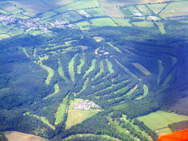
Woburn Golf and Country Club
Plan your visit
⛳ Golf🦅 Birds🦉 Wildlife
Public access Paid entry Dogs welcome
Places › England › South East › Milton Keynes Getting here
51.99124, -0.66057
Open directionsv Visiting this summer
Seasonal nature notes and what to look for now
▾ 🐦 70+ species recorded in this area — summer evenings are best for activity; watch for Carrion Crow and Woodpigeon ⛳ Golf is at its best in summer here 🐕 Dogs welcome — bring water in summer; the site has enough space to find shade on hot days 🌤️ Visiting this summer
🐦 70+ species recorded in this area — summer evenings are best for activity; watch for Carrion Crow and Woodpigeon ⛳ Golf is at its best in summer here 🐕 Dogs welcome — bring water in summer; the site has enough space to find shade on hot days 🦅 Bird watching
Very strong match
Birds — Carrion Crow, Woodpigeon, Magpie +67 more · last seen 2026; Birds — Carrion Crow, Woodpigeon, Magpie +67 more · last seen 2026
Free
🦉 Wildlife
Very strong match
Multi-group wildlife — Birds, Mammals; Multi-group wildlife — Birds, Mammals
Free
🦋 Insect spotting
Strong match
Lowland heathland — silver-studded blue and heath fritillary butterflies; Insects — Acantholyda hieroglyphica, Eristalis pertinax, Fries’ Larch Sawyer +36 more · last seen 2026
Free
Dogs allowed with public access
Free
Deciduous woodland — fungi, berries and wild garlic
Varies
Trails nearby Within roughly 5 km 7 signed routes nearby · 51 public paths nearby
Signed route nearby Public paths
Grand Union Canal Walk Walking route ▾
Napton to Coy Carp section
Named route Regional walking route
Show on map Clay Way Walking route ▾
Named route Point-to-point Local walking route
Show on map Milton Keynes Boundary Walk Walking route ▾
Named route Round trip Regional walking route
Show on map Seven Parishes Millennium Circular Walk Walking route 21.6 km ▾
Named route Length 21.6 km Round trip Local walking route
Show on map Western Historic Parkland Walk Walking route 6 km ▾
Named route Length 6 km Round trip Local walking route
Show on map Parkway public footpath · 83 m ▾
Public path public footpath Length 83 m Path type: residential
Show on map 101 signed routes nearby
Signed route nearby
NCN 51 Cycling route ▾
Named route Ref 51 National Cycle Network
Show on map Greensand Cycleway Cycling route 59 km ▾
Named route Length 59 km Regional cycle route
Show on map (6) Cycling route ▾
National Cycle Network link route
Named route Local cycle route
Show on map MK Redway Super Route V10 Cycling route ▾
Named route Ref V10 Local cycle route
Show on map MK Redway Super Route H8 Cycling route ▾
Named route Ref H8 Local cycle route
Show on map Millennium Circular Route Cycling route ▾
Named route Ref M Local cycle route
Show on map 1 signed route nearby
Signed route nearby
Longslade Trail Mountain bike route ▾
21 public paths nearby
Public paths
Sandy Lane byway open to all traffic · 74 m ▾
This is not really a road, more a sand track. This section is mainly use as a car park for local walkers.
Public path byway open to all traffic Length 74 m Surface sand Path type: track
Show on map Sandy Lane byway open to all traffic · 214 m ▾
This is not really a road, more a sand track. This section is mainly use as a car park for local walkers.
Public path byway open to all traffic Length 214 m Surface sand Path type: track
Show on map Sandy Lane byway open to all traffic · 629 m ▾
Public path byway open to all traffic Length 629 m Path type: track
Show on map
Weather for this location Next 14 days Nearby places Useful places within 5 km
All Historic
Own or manage this place?
Claim this listing to keep details accurate, add photos, and highlight what makes it special — free.
Claim this page→ How useful was the information on this page?
id: 17ec9b67-add7-4b5a-9f81-c8bdce514de8
UK green spaces mapped from open public data — so anyone can find the woodland, trail, or nature reserve closest to them.
© 2026 Glade · Made with care for UK green spaces
Events & activities nearby Switch provider to compare local events, tours and bookable activities.
Bookable tours GetYourGuide Promote here
Wildlife to spot
9,074 records · National Biodiversity Network
▾
Wildlife to spot 9,074 records · National Biodiversity Network Robin · Crossbill · Great Tit · Blackbird · Carrion Crow +39
Robin Erithacus rubecula Crossbill Loxia curvirostra2025 Great Tit Parus major Blackbird Turdus merula2025 Carrion Crow Corvus corone2025 Woodpigeon Columba palumbus Coal Tit Periparus ater2025 Jay Garrulus glandarius Blue Tit Cyanistes caeruleus2025 Wren Troglodytes troglodytes2025 Treecreeper Certhia familiaris2025 Chaffinch Fringilla coelebs Goldcrest Regulus regulus2025 Nuthatch Sitta europaea2025 Great Spotted Woodpecker Dendrocopos major2025 Chiffchaff Phylloscopus collybita2025 Magpie Pica pica2025 Stock Dove Columba oenas2025 Long-tailed Tit Aegithalos caudatus Goldfinch Carduelis carduelis2025 Song Thrush Turdus philomelos2025 Willow Warbler Phylloscopus trochilus2025 Blackcap Sylvia atricapilla2025 Mallard Anas platyrhynchos Dunnock Prunella modularis2025 Siskin Spinus spinus2025 Jackdaw Coloeus monedula2025 Spotted Flycatcher Muscicapa striata2025 Green Woodpecker Picus viridis2025 Coot Fulica atra Woodcock Scolopax rusticola2025 Black-headed Gull Chroicocephalus ridibundus2025 Raven Corvus corax2025 Herring Gull Larus argentatus2025 Yellowhammer Emberiza citrinella2025 Redwing Turdus iliacus2025 Skylark Alauda arvensis2025 Pheasant Phasianus colchicus2025 Meadow Pipit Anthus pratensis2025 Pied Wagtail Motacilla alba yarrellii2025 Rook Corvus frugilegus2025 Swallow Hirundo rustica2025 Moorhen Gallinula chloropus2025 Periparus ater britannicus Periparus ater britannicus2025 Grey Squirrel
Grey Squirrel Sciurus carolinensis 🐝 Insects 22 species
spring summer
2026 ▾
Eristalis pertinax · 24-spot Ladybird · 10-spot Ladybird · Eulachnus agilis · Gorse Weevil +17
Eristalis pertinax Eristalis pertinax 24-spot Ladybird Subcoccinella vigintiquattuorpunctata 10-spot Ladybird Adalia decempunctata Eulachnus agilis Eulachnus agilis Gorse Weevil Exapion ulicis 7-spot Ladybird Coccinella septempunctata Bittersweet
Bittersweet Solanum dulcamara Species observations from the last 10 years via NBN Atlas
Pine Ladybird Exochomus quadripustulatus
Pine Ladybird Exochomus quadripustulatus
Dark-edged Bee-fly Bombylius major
Dark-edged Bee-fly Bombylius major
Calathus rotundicollis Calathus rotundicollis2025
Calathus rotundicollis Calathus rotundicollis2025
Snail Hunter Cychrus caraboides2025
Snail Hunter Cychrus caraboides2025
Limodromus assimilis Limodromus assimilis2025
Limodromus assimilis Limodromus assimilis2025
Parent Bug Elasmucha grisea2025
Parent Bug Elasmucha grisea2025
Black Clock Pterostichus madidus2025
Black Clock Pterostichus madidus2025
Southern Oak Bush-cricket Meconema meridionale2025
Southern Oak Bush-cricket Meconema meridionale2025
Red-legged Shieldbug Pentatoma rufipes2025
Red-legged Shieldbug Pentatoma rufipes2025
Plagiognathus (Plagiognathus) arbustorum Plagiognathus (Plagiognathus) arbustorum2025
Plagiognathus (Plagiognathus) arbustorum Plagiognathus (Plagiognathus) arbustorum2025
Helophilus hybridus Helophilus hybridus2025
Helophilus hybridus Helophilus hybridus2025
Emperor Dragonfly Anax imperator2025
Emperor Dragonfly Anax imperator2025
18-spot Ladybird Myrrha octodecimguttata2025
18-spot Ladybird Myrrha octodecimguttata2025
Welsh Chafer Hoplia philanthus2025
Welsh Chafer Hoplia philanthus2025
Harlequin Ladybird Harmonia axyridis2025
Harlequin Ladybird Harmonia axyridis2025
Speckled Bush-cricket Leptophyes punctatissima2025
Speckled Bush-cricket Leptophyes punctatissima2025